TopoQuest Logo
Do you find TopoQuest useful?
Help keep TopoQuest running and adding new maps/features by donating!
Bitcoin:  19c7KJd3qBynnjoSw5npx9KScwjBe4ifkT
Litecoin:  LXs6TkuXGGXo1vDsWCkWVdjQX94eUKd6ui
Home View Maps Find Maps Find Places Resources & Links


Edgerton, Wisconsin Topographic Map

USGS Map Title: Edgerton, WI
USGS Map MRC: 42089G1
DRG (GeoTIFF) Download: o42089g1.tif


Neighboring USGS Topographic Map Quads:


  Stoughton, WI  
42089H2
 

  Rockdale, WI  
42089H1
 

  Busseyville, WI  
42088H8
 

  Cooksville, WI  
42089G2
 

  Edgerton, WI  
42089G1
 

  Milton, WI  
42088G8
 

  Footville, WI  
42089F2
 

  Janesville West, WI  
42089F1
 

  Janesville East, WI  
42088F8


Map MRC Location:

N43°
W90°
N43°
W89°
H8 H7 H6 H5 H4 H3 H2 H1
G8 G7 G6 G5 G4 G3 G2 G1
F8 F7 F6 F5 F4 F3 F2 F1
E8 E7 E6 E5 E4 E3 E2 E1
D8 D7 D6 D5 D4 D3 D2 D1
C8 C7 C6 C5 C4 C3 C2 C1
B8 B7 B6 B5 B4 B3 B2 B1
A8 A7 A6 A5 A4 A3 A2 A1
N42°
W90°
N42°
W89°

Edgerton, WI USGS 1:24K Topographic Map Preview:
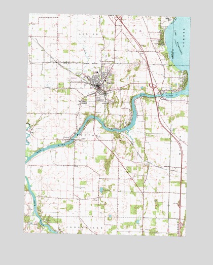
Edgerton, WI USGS Topographic Map
Click on map above to begin viewing in our Map Viewer.

This topographic map contains these locations and features:
Feature Name Type Latitude Longitude GNIS ID View Map
Albion SchoolSchoolN42.8747°W89.0632°1560734View Map
Camp Indian TrailsLocaleN42.7575°W89.1090°1562617View Map
Central Lutheran ChurchChurchN42.8358°W89.0684°1833951View Map
Central ParkParkN42.8372°W89.0673°1562902View Map
Child High SchoolSchoolN42.8361°W89.0709°1833954View Map
City of EdgertonCivilN42.8385°W89.0699°1583133View Map
Coopers ShoresPopulated PlaceN42.8325°W89.0115°1833976View Map
Cox SchoolSchoolN42.7886°W89.0871°1833977View Map
Curtis Universal Ambulance Service EdgertonBuildingN42.8351°W89.0755°2698365View Map
EdgertonPopulated PlaceN42.8353°W89.0676°1564443View Map
Edgerton Beach ParkPopulated PlaceN42.8675°W89.0212°1842399View Map
Edgerton City HallBuildingN42.8350°W89.0723°1833982View Map
Edgerton Community Elementary SchoolSchoolN42.8423°W89.0712°1833983View Map
Edgerton Fire DistrictBuildingN42.8404°W89.0631°2697906View Map
Edgerton High SchoolSchoolN42.8424°W89.0736°2716659View Map
Edgerton HospitalHospitalN42.8347°W89.0443°1833984View Map
Edgerton Middle SchoolSchoolN42.8418°W89.0761°1833985View Map
Edgerton Police DepartmentBuildingN42.8345°W89.0718°2759425View Map
Edgerton PondLakeN42.8333°W89.0756°2764356View Map
Edgerton Post OfficePost OfficeN42.8356°W89.0712°1833986View Map
Edgerton Public LibraryBuildingN42.8364°W89.0718°1833987View Map
Edgerton Wastewater Treatment PlantLocaleN42.8253°W89.0628°2709367View Map
Fassett CemeteryCemeteryN42.8249°W89.0807°1564877View Map
First Congregational ChurchChurchN42.8353°W89.0698°1834017View Map
Fulton Town Police DepartmentBuildingN42.7942°W89.0559°2759962View Map
Hans AdditionPopulated PlaceN42.8314°W89.0537°1834046View Map
Hickory HillsPopulated PlaceN42.8639°W89.0218°1842458View Map
HighwoodPopulated PlaceN42.8600°W89.0218°1842460View Map
Indian HeightsPopulated PlaceN42.8522°W89.0182°1842475View Map
IndianfordPopulated PlaceN42.8042°W89.0912°1581155View Map
Indianford WD-60 DamDamN42.8050°W89.0901°1792805View Map
Jana AirportAirportN42.8747°W89.0758°1581961View Map
Jenson CemeteryCemeteryN42.8239°W89.0842°1834068View Map
Lake Koshkonong 2594ReservoirN42.8050°W89.0901°1792806View Map
Legion ParkParkN42.8417°W89.0859°1567947View Map
MallwoodPopulated PlaceN42.8367°W89.0043°1834081View Map
Maple BeachPopulated PlaceN42.8420°W89.0037°1834083View Map
NewvillePopulated PlaceN42.8289°W89.0215°1570270View Map
Oakdale SchoolSchoolN42.7897°W89.0140°1570694View Map
Oaklawn AcademySchoolN42.8737°W89.0179°2716678View Map
Rock River Landing Strip (historical)AirportN42.7761°W89.0826°1834148View Map
Saint Johns Evangelical Lutheran ChurchChurchN42.8300°W89.0696°1834158View Map
Saint Johns SchoolSchoolN42.8297°W89.0687°1834162View Map
Saint Joseph Catholic ChurchChurchN42.8453°W89.0640°1834163View Map
Saint Joseph CollegeSchoolN42.8739°W89.0176°1573164View Map
Saint Joseph Parish CemeteryCemeteryN42.8252°W89.0842°1834164View Map
Saunders CreekStreamN42.8150°W89.0651°1573740View Map
Tobacco City MuseumBuildingN42.8350°W89.0718°1834203View Map
Town of FultonCivilN42.8001°W89.0725°1583252View Map
Towne Country ClubLocaleN42.8375°W89.0618°1834204View Map
Tri-County Community CenterBuildingN42.8358°W89.0712°1834208View Map
Trinity Lutheran ChurchChurchN42.8292°W89.0784°1834207View Map
Veterans Memorial BuildingBuildingN42.8406°W89.0726°1834210View Map
Willies PondLakeN42.7753°W89.0658°1576773View Map
WSJY-FM (Fort Atkinson)TowerN42.8006°W89.0546°1582597View Map
Yahara Elementary SchoolSchoolN42.8423°W89.0712°2716345View Map
Yahara RiverStreamN42.7931°W89.1229°1577073View Map

Note: Coordinates in the location and feature list above are referenced to NAD83 datum.


Copyright (C) 2008-2024 Ryan Niemi / Sunset Dynamics ... All Rights Reserved