TopoQuest Logo
Do you find TopoQuest useful?
Help keep TopoQuest running and adding new maps/features by donating!
Bitcoin:  19c7KJd3qBynnjoSw5npx9KScwjBe4ifkT
Litecoin:  LXs6TkuXGGXo1vDsWCkWVdjQX94eUKd6ui
Home View Maps Find Maps Find Places Resources & Links


Johannesburg, Michigan Topographic Map

USGS Map Title: Johannesburg, MI
USGS Map MRC: 44084H4
DRG (GeoTIFF) Download: o44084h4.tif


Neighboring USGS Topographic Map Quads:


  Sparr, MI  
45084A5
 

  Saunders Creek, MI  
45084A4
 

  Hetherton, MI  
45084A3
 

  Turtle Lake, MI  
44084H5
 

  Johannesburg, MI  
44084H4
 

  Lewiston, MI  
44084H3
 

  K P Lake, MI  
44084G5
 

  Lovells, MI  
44084G4
 

  Comstock Hills, MI  
44084G3


Map MRC Location:

N45°
W85°
N45°
W84°
H8 H7 H6 H5 H4 H3 H2 H1
G8 G7 G6 G5 G4 G3 G2 G1
F8 F7 F6 F5 F4 F3 F2 F1
E8 E7 E6 E5 E4 E3 E2 E1
D8 D7 D6 D5 D4 D3 D2 D1
C8 C7 C6 C5 C4 C3 C2 C1
B8 B7 B6 B5 B4 B3 B2 B1
A8 A7 A6 A5 A4 A3 A2 A1
N44°
W85°
N44°
W84°

Johannesburg, MI USGS 1:24K Topographic Map Preview:
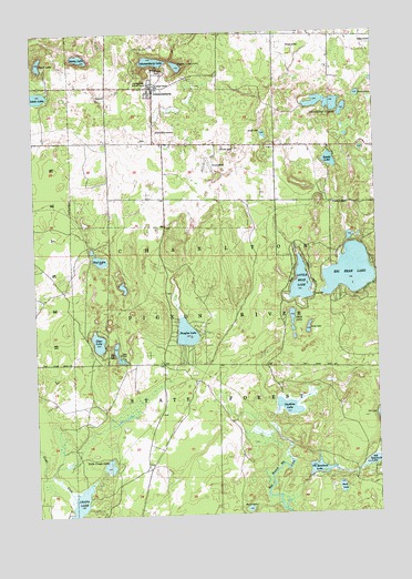
Johannesburg, MI USGS Topographic Map
Click on map above to begin viewing in our Map Viewer.

This topographic map contains these locations and features:
Feature Name Type Latitude Longitude GNIS ID View Map
Adams LakeLakeN44.9836°W84.3809°619824View Map
Allen ParkParkN44.9167°W84.4692°619982View Map
Big Bear LakeLakeN44.9374°W84.3846°621289View Map
Big Bear Lake State Forest CampgroundLocaleN44.9439°W84.3792°2492475View Map
Camp BellLocaleN44.9314°W84.3981°622541View Map
Caulkins LakeLakeN44.9026°W84.4080°622883View Map
Charlton Town Hall and ChurchChurchN44.9867°W84.4578°623120View Map
Charlton Township Fire DepartmentBuildingN44.9830°W84.4573°2626866View Map
Clear LakeLakeN44.9199°W84.4770°623424View Map
Crapo CreekStreamN44.8808°W84.4859°624018View Map
Crapo LakeLakeN44.8773°W84.4850°624021View Map
Denny LakeLakeN44.9937°W84.4820°624551View Map
Douglas LakeLakeN44.9220°W84.4447°624827View Map
Duck LakeLakeN44.9263°W84.4060°624935View Map
Dudd LakeLakeN44.9734°W84.4153°624955View Map
Echo Valley ResortLocaleN44.9906°W84.4539°625332View Map
Ell LakeLakeN44.9148°W84.4690°625471View Map
Full Gospel ChurchChurchN44.9864°W84.4553°626550View Map
Ginsel LakeLakeN44.9924°W84.4972°626850View Map
Hill Side FarmLocaleN44.9700°W84.4309°628291View Map
JohannesburgPopulated PlaceN44.9856°W84.4559°629295View Map
Johannesburg Branch LibraryBuildingN44.9856°W84.4558°2492637View Map
Johannesburg CemeteryCemeteryN44.9742°W84.4556°629296View Map
Johannesburg LakeLakeN44.9927°W84.4554°629297View Map
Johannesburg Post OfficePost OfficeN44.9856°W84.4592°2492638View Map
Johannesburg Station (historical)LocaleN44.9856°W84.4558°2492635View Map
Johannesburg-Lewiston High SchoolSchoolN44.9828°W84.4547°2492636View Map
Kujawa or Burg LakeLakeN44.9913°W84.4464°629888View Map
Lewis LakeLakeN44.9833°W84.4997°630351View Map
Little Bear LakeLakeN44.9347°W84.4026°630555View Map
Little Crapo LakeLakeN44.8877°W84.4738°630601View Map
Long LakeLakeN44.9230°W84.4002°630944View Map
Mud LakeLakeN44.9411°W84.4760°633004View Map
Perch LakeLakeN44.8817°W84.3888°634636View Map
Round LakeLakeN44.8763°W84.4229°636308View Map
Seventh Spectacle LakeLakeN44.8866°W84.3973°637603View Map
Sixth Spectacle LakeLakeN44.8883°W84.3775°638044View Map
Swede LakeLakeN44.9666°W84.3913°1614481View Map
Township of CharltonCivilN44.9862°W84.4290°1626063View Map
Traverse LakesLakeN44.9810°W84.3900°1615046View Map

Note: Coordinates in the location and feature list above are referenced to NAD83 datum.


Copyright (C) 2008-2024 Ryan Niemi / Sunset Dynamics ... All Rights Reserved