TopoQuest Logo
Do you find TopoQuest useful?
Help keep TopoQuest running and adding new maps/features by donating!
Bitcoin:  19c7KJd3qBynnjoSw5npx9KScwjBe4ifkT
Litecoin:  LXs6TkuXGGXo1vDsWCkWVdjQX94eUKd6ui
Home View Maps Find Maps Find Places Resources & Links


Johnston City, Illinois Topographic Map

USGS Map Title: Johnston City, IL
USGS Map MRC: 37088G8
DRG (GeoTIFF) Download: o37088g8.tif


Neighboring USGS Topographic Map Quads:


  Christopher, IL  
37089H1
 

  West Frankfort, IL  
37088H8
 

  Thompsonville, IL  
37088H7
 

  Herrin, IL  
37089G1
 

  Johnston City, IL  
37088G8
 

  Pittsburg, IL  
37088G7
 

  Crab Orchard Lake, IL  
37089F1
 

  Marion, IL  
37088F8
 

  Crab Orchard, IL  
37088F7


Map MRC Location:

N38°
W89°
N38°
W88°
H8 H7 H6 H5 H4 H3 H2 H1
G8 G7 G6 G5 G4 G3 G2 G1
F8 F7 F6 F5 F4 F3 F2 F1
E8 E7 E6 E5 E4 E3 E2 E1
D8 D7 D6 D5 D4 D3 D2 D1
C8 C7 C6 C5 C4 C3 C2 C1
B8 B7 B6 B5 B4 B3 B2 B1
A8 A7 A6 A5 A4 A3 A2 A1
N37°
W89°
N37°
W88°

Johnston City, IL USGS 1:24K Topographic Map Preview:
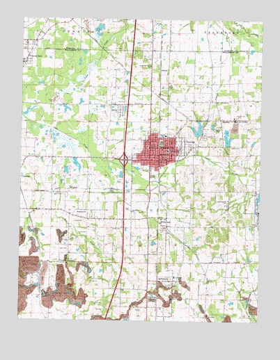
Johnston City, IL USGS Topographic Map
Click on map above to begin viewing in our Map Viewer.

This topographic map contains these locations and features:
Feature Name Type Latitude Longitude GNIS ID View Map
Allen Hunter CemeteryCemeteryN37.7828°W88.9745°410694View Map
Bear CreekStreamN37.8170°W88.9767°404010View Map
Becker CemeteryCemeteryN37.8225°W88.8867°404076View Map
Blair CemeteryCemeteryN37.8300°W88.8978°403798View Map
Boyd CemeteryCemeteryN37.7964°W88.9431°404755View Map
Camp Ground CemeteryCemeteryN37.7567°W88.9612°405527View Map
Cedar Grove United Methodist ChurchChurchN37.7642°W88.9334°1824141View Map
Church of God of ProphecyChurchN37.8228°W88.9303°1824150View Map
City of Johnston CityCivilN37.8214°W88.9286°2395475View Map
Crenshaw CrossingPopulated PlaceN37.7739°W88.9795°406767View Map
Cross Road CemeteryCemeteryN37.7500°W88.8751°406834View Map
Dog WalkPopulated PlaceN37.7592°W88.9328°407282View Map
Duncan CemeteryCemeteryN37.8403°W88.9370°407482View Map
Evangelical ChurchChurchN37.7956°W88.9412°408094View Map
Ferges CemeteryCemeteryN37.7912°W88.9720°408326View Map
FergestownPopulated PlaceN37.7925°W88.9648°408327View Map
First Baptist Church of Johnston CityChurchN37.8173°W88.9245°1824171View Map
First Christian ChurchChurchN37.8164°W88.9231°1824174View Map
First United Methodist Church of Johnston CityChurchN37.8170°W88.9320°1824183View Map
Follis CemeteryCemeteryN37.8631°W88.9478°408482View Map
Freeman Number 4 MineMineN37.7945°W88.8759°424904View Map
Freeman SpurPopulated PlaceN37.8612°W88.9973°408731View Map
Gospel Mission ChurchChurchN37.8214°W88.9117°1824186View Map
Harmony ChurchChurchN37.8625°W88.8826°409803View Map
Hart CemeteryCemeteryN37.8406°W88.9459°409872View Map
Herrin Election PrecinctCivilN37.8180°W88.9842°2397413View Map
Hock CemeteryCemeteryN37.8303°W88.9056°410332View Map
Illinois No Name Number 2010 DamDamN37.8134°W88.8967°1692152View Map
Interchange 59CrossingN37.8167°W88.9462°1824201View Map
Jacob Hunter CemeteryCemeteryN37.7959°W88.9215°1988746View Map
Jefferson Elementary SchoolSchoolN37.8220°W88.9328°411060View Map
JenkinsPopulated PlaceN37.8542°W88.9276°422846View Map
Johnston CityPopulated PlaceN37.8206°W88.9276°411188View Map
Johnston City Fire DepartmentBuildingN37.8162°W88.9272°2640493View Map
Johnston City High SchoolSchoolN37.8267°W88.9245°1824204View Map
Johnston City Post OfficePost OfficeN37.8165°W88.9294°1737314View Map
Johnston City Public LibraryBuildingN37.8164°W88.9270°1824205View Map
Johnston City Sewage LagoonReservoirN37.8067°W88.9301°1691019View Map
Johnston City Sewage Lagoon DamDamN37.8067°W88.9301°1691018View Map
Johnston City Water Treatment PlantLocaleN37.8192°W88.9150°2740881View Map
Johnston Police DepartmentBuildingN37.8161°W88.9268°2758943View Map
Lake Creek ChurchChurchN37.8003°W88.8915°411707View Map
Lake Number 5ReservoirN37.8252°W88.8923°1691001View Map
Lake Number 5 DamDamN37.8234°W88.8917°1691000View Map
Lakeview CemeteryCemeteryN37.8267°W88.9037°411756View Map
Latter Day Saints ChurchChurchN37.8562°W88.9323°411844View Map
Moake CemeteryCemeteryN37.7753°W88.9759°413692View Map
Perry CemeteryCemeteryN37.7545°W88.9592°415558View Map
Ralls CemeteryCemeteryN37.7864°W88.9687°416359View Map
Reed CemeteryCemeteryN37.7798°W88.9753°416482View Map
Saint Pauls Catholic ChurchChurchN37.8212°W88.9265°1824232View Map
Saint Pauls ChurchChurchN37.8412°W88.8959°417717View Map
Saint Pauls SchoolSchoolN37.8192°W88.9270°417729View Map
Sanders CemeteryCemeteryN37.7759°W88.9441°417963View Map
Sanders CemeteryCemeteryN37.7882°W88.9473°417966View Map
Sanders Davis CemeteryCemeteryN37.7786°W88.9311°417964View Map
ShakeragPopulated PlaceN37.8223°W88.9090°418271View Map
Spiller CemeteryCemeteryN37.7600°W88.9867°418903View Map
SpillertownPopulated PlaceN37.7664°W88.9195°418904View Map
StiritzPopulated PlaceN37.8362°W88.9484°419149View Map
Stroud-Sehoskey CemeteryCemeteryN37.7664°W88.9628°419230View Map
Sweet LakeReservoirN37.8280°W88.9084°1690999View Map
Sweet Lake DamDamN37.8267°W88.9067°1690998View Map
Village of Freeman SpurCivilN37.8611°W88.9993°2398925View Map
Village of SpillertownCivilN37.7641°W88.9197°2399873View Map
Village of Whiteash (historical)CivilN37.7854°W88.9293°2400164View Map
Walker CemeteryCemeteryN37.8020°W88.9784°420398View Map
Washington Avenue Baptist ChurchChurchN37.8189°W88.9267°1824247View Map
Washington Elementary SchoolSchoolN37.8209°W88.9228°420574View Map
WDDD-AM (Johnston City)TowerN37.7542°W88.9348°428429View Map
WDDD-FM (Marion)TowerN37.7542°W88.9348°428512View Map
White AshPopulated PlaceN37.7895°W88.9248°2791543View Map
Whiteash Census Designated PlaceCensusN37.7853°W88.9294°2771129View Map
Williamson County Fire Protection District Station 5BuildingN37.8178°W88.9542°2640753View Map
Ziegler Number 4 MineMineN37.8356°W88.8873°425660View Map

Note: Coordinates in the location and feature list above are referenced to NAD83 datum.


Copyright (C) 2008-2024 Ryan Niemi / Sunset Dynamics ... All Rights Reserved