TopoQuest Logo
Do you find TopoQuest useful?
Help keep TopoQuest running and adding new maps/features by donating!
Bitcoin:  19c7KJd3qBynnjoSw5npx9KScwjBe4ifkT
Litecoin:  LXs6TkuXGGXo1vDsWCkWVdjQX94eUKd6ui
Home View Maps Find Maps Find Places Resources & Links


Crab Orchard, Illinois Topographic Map

USGS Map Title: Crab Orchard, IL
USGS Map MRC: 37088F7
DRG (GeoTIFF) Download: o37088f7.tif


Neighboring USGS Topographic Map Quads:


  Johnston City, IL  
37088G8
 

  Pittsburg, IL  
37088G7
 

  Harco, IL  
37088G6
 

  Marion, IL  
37088F8
 

  Crab Orchard, IL  
37088F7
 

  Carrier Mills, IL  
37088F6
 

  Goreville, IL  
37088E8
 

  Creal Springs, IL  
37088E7
 

  Stonefort, IL  
37088E6


Map MRC Location:

N38°
W89°
N38°
W88°
H8 H7 H6 H5 H4 H3 H2 H1
G8 G7 G6 G5 G4 G3 G2 G1
F8 F7 F6 F5 F4 F3 F2 F1
E8 E7 E6 E5 E4 E3 E2 E1
D8 D7 D6 D5 D4 D3 D2 D1
C8 C7 C6 C5 C4 C3 C2 C1
B8 B7 B6 B5 B4 B3 B2 B1
A8 A7 A6 A5 A4 A3 A2 A1
N37°
W89°
N37°
W88°

Crab Orchard, IL USGS 1:24K Topographic Map Preview:
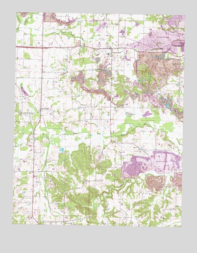
Crab Orchard, IL USGS Topographic Map
Click on map above to begin viewing in our Map Viewer.

This topographic map contains these locations and features:
Feature Name Type Latitude Longitude GNIS ID View Map
Arnold CemeteryCemeteryN37.6612°W88.7939°403629View Map
Arnold School (historical)SchoolN37.6700°W88.7812°1737342View Map
Arnold View ChurchChurchN37.6692°W88.7815°403635View Map
Atwood CemeteryCemeteryN37.6503°W88.8578°403712View Map
Barbara Kay MineMineN37.7348°W88.8098°403884View Map
Bethlehem CemeteryCemeteryN37.7370°W88.8689°404333View Map
Brushy CreekStreamN37.6284°W88.8084°424682View Map
Buckley CreekStreamN37.7437°W88.8723°405137View Map
Cana ChurchChurchN37.6556°W88.8603°405538View Map
Cana CreekStreamN37.6750°W88.8473°424706View Map
Caplinger PondLakeN37.7031°W88.8680°405571View Map
Central School (historical)SchoolN37.7350°W88.7626°1737351View Map
Cherry Valley School (historical)SchoolN37.6964°W88.8745°1737354View Map
Coal Bank Springs ChurchChurchN37.7206°W88.7526°406278View Map
Corley School (historical)SchoolN37.7000°W88.8365°1737359View Map
Crab OrchardPopulated PlaceN37.7292°W88.8042°406699View Map
Crab Orchard Census Designated PlaceCensusN37.7250°W88.8059°2628548View Map
Crab Orchard Election PrecinctCivilN37.7317°W88.7624°2397407View Map
Crab Orchard High SchoolSchoolN37.7262°W88.8065°1824154View Map
Crabtree School (historical)SchoolN37.7231°W88.8742°1737360View Map
Creal Springs CemeteryCemeteryN37.6253°W88.8287°424794View Map
Creal Springs Election PrecinctCivilN37.6415°W88.8735°2397408View Map
Davis Prairie ChurchChurchN37.7292°W88.8401°406980View Map
Delta MineMineN37.7028°W88.7651°407112View Map
Donelson CemeteryCemeteryN37.6334°W88.8589°407302View Map
Donelson School (historical)SchoolN37.6317°W88.8598°1737362View Map
East Marion Election PrecinctCivilN37.7304°W88.8727°2397409View Map
Edwards CemeteryCemeteryN37.7289°W88.8173°407801View Map
Fairview ChurchChurchN37.6514°W88.8217°408190View Map
Ferrell ChurchChurchN37.6953°W88.7959°408340View Map
Little Cana CreekStreamN37.6537°W88.8545°412299View Map
Little Crab Orchard CreekStreamN37.7437°W88.8728°412307View Map
Moore CemeteryCemeteryN37.6903°W88.8637°413776View Map
Motsinger School (historical)SchoolN37.7006°W88.8037°1737325View Map
Mount Pleasant ChurchChurchN37.7167°W88.8151°414049View Map
New DennisonPopulated PlaceN37.6928°W88.8556°414392View Map
Odumburg School (historical)SchoolN37.6492°W88.8326°1737332View Map
Old Krieger CemeteryCemeteryN37.6906°W88.8664°415023View Map
PalzoPopulated PlaceN37.6487°W88.7634°1737334View Map
Parks CemeteryCemeteryN37.6720°W88.7828°415405View Map
Parks School (historical)SchoolN37.7034°W88.7637°1737335View Map
Pleasant Grove CemeteryCemeteryN37.7439°W88.7995°415778View Map
Pulley CemeteryCemeteryN37.7456°W88.8317°416283View Map
RodgersvillePopulated PlaceN37.6767°W88.7698°1736164View Map
Spring Hill CemeteryCemeteryN37.6359°W88.7592°419007View Map
Springhill ChurchChurchN37.6484°W88.7642°419008View Map
Stonefort Election PrecinctCivilN37.6438°W88.7633°2397418View Map
Tanner CemeteryCemeteryN37.6598°W88.7778°419539View Map
Walnut Hill ChurchChurchN37.7009°W88.8037°420475View Map
WillefordPopulated PlaceN37.6562°W88.8517°1736176View Map
Williamson County Fire Protection District Station 3BuildingN37.7319°W88.7985°2640598View Map
Wilson School (historical)SchoolN37.7228°W88.8365°1736178View Map
Worley CemeteryCemeteryN37.7170°W88.8667°421505View Map
Wright School (historical)SchoolN37.6375°W88.7859°1736179View Map

Note: Coordinates in the location and feature list above are referenced to NAD83 datum.


Copyright (C) 2008-2024 Ryan Niemi / Sunset Dynamics ... All Rights Reserved