TopoQuest Logo
Do you find TopoQuest useful?
Help keep TopoQuest running and adding new maps/features by donating!
Bitcoin:  19c7KJd3qBynnjoSw5npx9KScwjBe4ifkT
Litecoin:  LXs6TkuXGGXo1vDsWCkWVdjQX94eUKd6ui
Home View Maps Find Maps Find Places Resources & Links


Kinder, Louisiana Topographic Map

USGS Map Title: Kinder, LA
USGS Map MRC: 30092D7
DRG (GeoTIFF) Download: o30092d7.tif


Neighboring USGS Topographic Map Quads:


  Le Blanc, LA  
30092E8
 

  Oberlin, LA  
30092E7
 

  Soileau, LA  
30092E6
 

  Indian Village, LA  
30092D8
 

  Kinder, LA  
30092D7
 

  Elton, LA  
30092D6
 

  Fenton, LA  
30092C8
 

  Welsh North, LA  
30092C7
 

  Hathaway, LA  
30092C6


Map MRC Location:

N31°
W93°
N31°
W92°
H8 H7 H6 H5 H4 H3 H2 H1
G8 G7 G6 G5 G4 G3 G2 G1
F8 F7 F6 F5 F4 F3 F2 F1
E8 E7 E6 E5 E4 E3 E2 E1
D8 D7 D6 D5 D4 D3 D2 D1
C8 C7 C6 C5 C4 C3 C2 C1
B8 B7 B6 B5 B4 B3 B2 B1
A8 A7 A6 A5 A4 A3 A2 A1
N30°
W93°
N30°
W92°

Kinder, LA USGS 1:24K Topographic Map Preview:
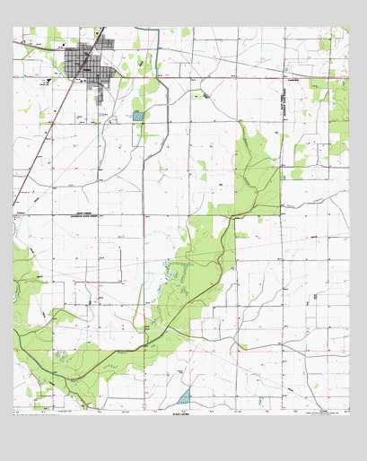
Kinder, LA USGS Topographic Map
Click on map above to begin viewing in our Map Viewer.

This topographic map contains these locations and features:
Feature Name Type Latitude Longitude GNIS ID View Map
Allen Parish HospitalHospitalN30.4925°W92.8560°2601002View Map
Allen Parish Library Kinder BranchBuildingN30.4872°W92.8494°2603016View Map
Bayou AlligatorStreamN30.4396°W92.7863°532425View Map
Christ Praise and Worship CenterChurchN30.4852°W92.8506°2601471View Map
Church Alive of KinderChurchN30.4867°W92.8430°2601652View Map
CoverdalePopulated PlaceN30.4844°W92.7746°543113View Map
First Baptist ChurchChurchN30.4873°W92.8471°2601720View Map
First United Methodist ChurchChurchN30.4891°W92.8498°2601990View Map
Hannah Chapel African Methodist Episcopal ChurchChurchN30.4926°W92.8489°2601879View Map
KinderPopulated PlaceN30.4855°W92.8507°536191View Map
Kinder Bible ChurchChurchN30.4872°W92.8520°2602110View Map
Kinder CanalCanalN30.4405°W92.8265°536192View Map
Kinder Church of ChristChurchN30.4842°W92.8547°2602111View Map
Kinder DitchCanalN30.4483°W92.8671°536194View Map
Kinder Elementary SchoolSchoolN30.4881°W92.8445°545449View Map
Kinder Fire DepartmentBuildingN30.4841°W92.8491°2332392View Map
Kinder High SchoolSchoolN30.4815°W92.8616°545450View Map
Kinder Middle SchoolSchoolN30.4888°W92.8443°2493326View Map
Kinder Police DepartmentBuildingN30.4854°W92.8498°2334035View Map
Kinder Post OfficePost OfficeN30.4883°W92.8490°1630166View Map
Kinder Water Treatment PlantLocaleN30.4769°W92.8572°2603379View Map
LauderdalePopulated PlaceN30.4813°W92.7751°541126View Map
Louisiana Noname 107 DamDamN30.4685°W92.8268°556979View Map
McGee CemeteryCemeteryN30.4924°W92.8704°536992View Map
New Hope Assembly ChurchChurchN30.4627°W92.8638°2602321View Map
North Edna Oil FieldOilfieldN30.4252°W92.7765°545861View Map
Parish Governing Authority District 6CivilN30.4997°W92.7965°1930118View Map
Saint Philip Neri ChurchChurchN30.4871°W92.8526°2602758View Map
Thompson Spur (historical)LocaleN30.4566°W92.8663°545475View Map
Town of KinderCivilN30.4835°W92.8508°2405949View Map
Ward TwoCivilN30.4983°W92.8307°544887View Map
West Edna Gas FieldOilfieldN30.4002°W92.8488°545887View Map

Note: Coordinates in the location and feature list above are referenced to NAD83 datum.


Copyright (C) 2008-2024 Ryan Niemi / Sunset Dynamics ... All Rights Reserved