TopoQuest Logo
Do you find TopoQuest useful?
Help keep TopoQuest running and adding new maps/features by donating!
Bitcoin:  19c7KJd3qBynnjoSw5npx9KScwjBe4ifkT
Litecoin:  LXs6TkuXGGXo1vDsWCkWVdjQX94eUKd6ui
Home View Maps Find Maps Find Places Resources & Links


Kinsale, Virginia Topographic Map

USGS Map Title: Kinsale, VA
USGS Map MRC: 38076A5
DRG (GeoTIFF) Download: o38076a5.tif


Neighboring USGS Topographic Map Quads:


  Saint Clements Island, MD  
38076B6
 

  Piney Point, MD  
38076B5
 

  St. Marys City, MD  
38076B4
 

  Machodoc, VA  
38076A6
 

  Kinsale, VA  
38076A5
 

  Saint George Island, MD  
38076A4
 

  Haynesville, VA  
37076H6
 

  Lottsburg, VA  
37076H5
 

  Heathsville, VA  
37076H4


Map MRC Location:

N39°
W77°
N39°
W76°
H8 H7 H6 H5 H4 H3 H2 H1
G8 G7 G6 G5 G4 G3 G2 G1
F8 F7 F6 F5 F4 F3 F2 F1
E8 E7 E6 E5 E4 E3 E2 E1
D8 D7 D6 D5 D4 D3 D2 D1
C8 C7 C6 C5 C4 C3 C2 C1
B8 B7 B6 B5 B4 B3 B2 B1
A8 A7 A6 A5 A4 A3 A2 A1
N38°
W77°
N38°
W76°

Kinsale, VA USGS 1:24K Topographic Map Preview:
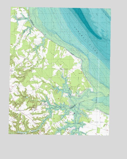
Kinsale, VA USGS Topographic Map
Click on map above to begin viewing in our Map Viewer.

This topographic map contains these locations and features:
Feature Name Type Latitude Longitude GNIS ID View Map
Allen PointCapeN38.0290°W76.5575°1462413View Map
Askins Shop (historical)LocaleN38.0737°W76.6030°1791366View Map
Bailey CemeteryCemeteryN38.0285°W76.5758°1779183View Map
Barn PointCapeN38.0260°W76.5363°1462795View Map
Barn Point LightLocaleN38.0312°W76.5366°1760719View Map
Bonum CreekStreamN38.0962°W76.5816°1463655View Map
Carmel CemeteryCemeteryN38.0432°W76.6225°1791378View Map
Carmel ChurchChurchN38.0421°W76.6236°1464446View Map
Carys CornerPopulated PlaceN38.0621°W76.6238°1477183View Map
Cedar PointCapeN38.0265°W76.5611°1464644View Map
Cherry Grove CreekStreamN38.1235°W76.6055°1464775View Map
Cherry Grove PondLakeN38.1240°W76.6043°1791380View Map
Cherry Point NeckCapeN38.0132°W76.5188°1464785View Map
Cople District Volunteer Fire Department Engine Company 3BuildingN38.0310°W76.5801°2085822View Map
Cornish CreekStreamN38.0240°W76.5386°1465266View Map
Crow BarCapeN38.0443°W76.5561°1465486View Map
Devils CornerLocaleN38.0749°W76.6061°1791387View Map
Drum CoveBayN38.0118°W76.5511°1465962View Map
Dungan CoveBayN38.0018°W76.5305°1466049View Map
Dungan PointCapeN38.0062°W76.5372°1466050View Map
Fauntleroy FarmLocaleN38.0243°W76.5166°1760767View Map
Gardner CreekStreamN38.1129°W76.6005°1466990View Map
Gardy MillpondReservoirN38.0018°W76.6079°1502374View Map
Gardy Millpond DamDamN38.0018°W76.6036°1491023View Map
Gardys Mill (historical)LocaleN38.0010°W76.6022°1760773View Map
Grays CornerPopulated PlaceN38.0237°W76.6122°1477370View Map
Great House PointCapeN38.0260°W76.5747°1467438View Map
Hampton Hall BranchStreamN38.0251°W76.5733°1467696View Map
Hampton Hall BridgeBridgeN38.0065°W76.5872°1760787View Map
Hampton Hall Creek LandingLocaleN38.0076°W76.5863°1779189View Map
HarryhoganPopulated PlaceN38.0071°W76.5441°1495659View Map
Harryhogan PointCapeN38.0065°W76.5441°1760790View Map
Horn PointCapeN38.0290°W76.5491°1468244View Map
Hudsons LandingLocaleN38.0243°W76.5663°1760799View Map
Jackson CreekStreamN38.1068°W76.5972°1468599View Map
KinsalePopulated PlaceN38.0296°W76.5808°1495796View Map
Kinsale BranchStreamN38.0279°W76.5727°1469031View Map
Kinsale ForkLocaleN38.0187°W76.6033°1791416View Map
Kinsale Methodist ChurchChurchN38.0293°W76.5805°1791417View Map
Kinsale Post OfficePost OfficeN38.0297°W76.5791°2519626View Map
Lodge CreekStreamN38.0099°W76.5408°1469735View Map
Long CoveBayN38.0299°W76.5661°1469802View Map
Long PointCapeN38.0246°W76.5555°1469829View Map
Lynch PointCapeN38.0429°W76.5225°1469952View Map
Mill CreekStreamN38.0099°W76.5408°1470511View Map
Mondays NeckCapeN38.0179°W76.5500°1760824View Map
Morrisons CornerPopulated PlaceN38.0015°W76.5802°1760826View Map
Mundy PointCapeN38.0224°W76.5427°1477029View Map
Mundy PointLocaleN38.0210°W76.5455°1471267View Map
New Jerusalem ChurchChurchN38.0201°W76.6133°1471458View Map
Northwest Yeocomico RiverStreamN38.0315°W76.5400°1471668View Map
Oyster Shell PointCapeN38.0257°W76.5716°1472011View Map
Palmer CoveBayN38.0112°W76.5330°1472026View Map
Palmer PointCapeN38.0118°W76.5380°1472027View Map
Parkers CreekStreamN38.0407°W76.5391°1472067View Map
Parkers IslandIslandN38.0385°W76.5394°1472069View Map
Pea NeckCapeN38.0024°W76.5533°1472141View Map
Pecatone NeckCapeN38.0946°W76.5997°1791445View Map
Sandy PointPopulated PlaceN38.0607°W76.5333°1496184View Map
Sandy PointCapeN38.0729°W76.5358°1477970View Map
Sandy Point Post OfficePost OfficeN38.0639°W76.5529°2519651View Map
Sanford FieldAirportN38.1197°W76.6137°1498639View Map
Seldom PointCapeN38.0285°W76.5619°1474158View Map
Shady Harbor ShoresPopulated PlaceN38.0429°W76.5669°1791456View Map
Shannon BranchStreamN38.0507°W76.5552°1474220View Map
Shingle HillSummitN38.0254°W76.5944°1496219View Map
Shivok AirportAirportN38.0090°W76.5630°1498613View Map
Sloop PointCapeN38.0282°W76.5669°1474701View Map
South Yeocomico RiverStreamN38.0315°W76.5400°1474903View Map
Thicket PointCapeN38.0268°W76.5166°1475626View Map
Thicket Point BayBayN38.0254°W76.5241°1475627View Map
Thompson Mill (historical)LocaleN38.0362°W76.6011°1791467View Map
Thompson MillpondReservoirN38.0363°W76.6030°1475660View Map
Tom Jones PointCapeN38.0212°W76.5363°1475761View Map
Tucker HillPopulated PlaceN38.0665°W76.5941°1496327View Map
Vault Field VineyardsBuildingN38.0161°W76.6246°2518593View Map
Walker PointCapeN38.0118°W76.5433°1476240View Map
West Yeocomico RiverStreamN38.0315°W76.5400°1476511View Map
WestmorelandPopulated PlaceN38.0643°W76.5588°1476528View Map
Wheatland TurnLocaleN38.0060°W76.5147°1760858View Map
White PointCapeN38.0404°W76.5502°1476629View Map
White Point CreekStreamN38.0426°W76.5552°1476632View Map
Wilkins CreekStreamN38.0240°W76.5511°1476737View Map
Yeocomico ChapelChurchN38.0643°W76.5594°1474342View Map
Yeocomico ChurchChurchN38.0624°W76.5969°1474343View Map
Yeocomico RiverStreamN38.0349°W76.5191°1474344View Map
Zion ChurchChurchN38.0701°W76.6111°1474400View Map

Note: Coordinates in the location and feature list above are referenced to NAD83 datum.


Copyright (C) 2008-2024 Ryan Niemi / Sunset Dynamics ... All Rights Reserved