TopoQuest Logo
Do you find TopoQuest useful?
Help keep TopoQuest running and adding new maps/features by donating!
Bitcoin:  19c7KJd3qBynnjoSw5npx9KScwjBe4ifkT
Litecoin:  LXs6TkuXGGXo1vDsWCkWVdjQX94eUKd6ui
Home View Maps Find Maps Find Places Resources & Links


Leipsic, Ohio Topographic Map

USGS Map Title: Leipsic, OH
USGS Map MRC: 41083A8
DRG (GeoTIFF) Download: o41083a8.tif


Neighboring USGS Topographic Map Quads:


  Hamler, OH  
41084B1
 

  Deshler, OH  
41083B8
 

  Hoytville, OH  
41083B7
 

  Ottawa, OH  
41084A1
 

  Leipsic, OH  
41083A8
 

  McComb, OH  
41083A7
 

  Columbus Grove, OH  
40084H1
 

  Bluffton, OH  
40083H8
 

  Rawson, OH  
40083H7


Map MRC Location:

N42°
W84°
N42°
W83°
H8 H7 H6 H5 H4 H3 H2 H1
G8 G7 G6 G5 G4 G3 G2 G1
F8 F7 F6 F5 F4 F3 F2 F1
E8 E7 E6 E5 E4 E3 E2 E1
D8 D7 D6 D5 D4 D3 D2 D1
C8 C7 C6 C5 C4 C3 C2 C1
B8 B7 B6 B5 B4 B3 B2 B1
A8 A7 A6 A5 A4 A3 A2 A1
N41°
W84°
N41°
W83°

Leipsic, OH USGS 1:24K Topographic Map Preview:
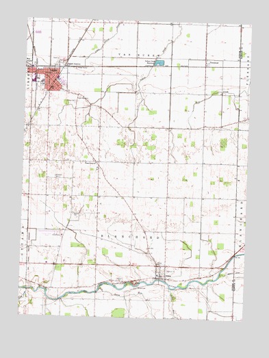
Leipsic, OH USGS Topographic Map
Click on map above to begin viewing in our Map Viewer.

This topographic map contains these locations and features:
Feature Name Type Latitude Longitude GNIS ID View Map
Blanchard CemeteryCemeteryN41.0589°W83.9819°1038102View Map
Blanchard Township Gilboa Fire DepartmentBuildingN41.0213°W83.9185°2549656View Map
Cholera CemeteryCemeteryN41.0231°W83.9236°1039081View Map
Crawfis CemeteryCemeteryN41.0128°W83.9333°1065466View Map
Crawfish College (historical)SchoolN41.0234°W83.9577°1050098View Map
Dukes RunStreamN41.0134°W83.9163°1065984View Map
Dutch RunStreamN41.0120°W83.9552°1065987View Map
First Christian ChurchChurchN41.1001°W83.9880°1961356View Map
First Lutheran ChurchChurchN41.0998°W83.9866°1961357View Map
GilboaPopulated PlaceN41.0181°W83.9219°1048782View Map
Gilboa Elementary SchoolSchoolN41.0184°W83.9233°1050102View Map
Gilboa Main Street Historic DistrictParkN41.0170°W83.9222°1069735View Map
Gilboa Post OfficePost OfficeN41.0181°W83.9222°2056187View Map
Gilboa Quarry (historical)MineN41.0147°W83.9356°2564638View Map
Gilboa United Methodist ChurchChurchN41.0173°W83.9241°1961367View Map
Harmon CemeteryCemeteryN41.0162°W83.9441°1041323View Map
Hovest FarmsLocaleN41.0094°W83.9528°2564636View Map
LeipsicPopulated PlaceN41.0984°W83.9847°1064984View Map
Leipsic Elementary SchoolSchoolN41.0987°W83.9908°1050101View Map
Leipsic Emergency Medical ServicesBuildingN41.0973°W83.9858°2550754View Map
Leipsic High SchoolSchoolN41.0992°W83.9902°1050100View Map
Leipsic JunctionPopulated PlaceN41.1064°W83.9780°1062848View Map
Leipsic Police DepartmentBuildingN41.0984°W83.9848°2732625View Map
Leipsic Post OfficePost OfficeN41.0987°W83.9847°2043356View Map
Leipsic Post Office (historical)Post OfficeN41.1070°W83.9777°2056194View Map
Leipsic Upground Reservoir DamDamN41.1067°W83.9283°1078962View Map
Leipsic Volunteer Fire Department Station 1BuildingN41.0972°W83.9860°2549655View Map
Leipsic Volunteer Fire Department Station 2BuildingN41.0993°W83.9824°2550606View Map
Maidlow CemeteryCemeteryN41.0434°W83.9710°1042898View Map
Melody Acres Trailer ParkPopulated PlaceN41.1081°W83.9806°2648382View Map
Orchard Lane Trailer CourtPopulated PlaceN41.1039°W83.9772°2648384View Map
Pleasant Grove ChurchChurchN41.0648°W83.9597°1070900View Map
Putnam County AirportAirportN41.0343°W83.9791°1082927View Map
Putnam County HomeBuildingN41.0342°W83.9772°1050099View Map
Riley CreekStreamN41.0114°W83.9983°1072244View Map
Saint Marys Catholic ChurchChurchN41.0973°W83.9899°1071360View Map
Saint Marys CemeteryCemeteryN41.0906°W83.9722°1045651View Map
Saint Marys SchoolSchoolN41.0970°W83.9888°1071361View Map
Sugar Ridge CemeteryCemeteryN41.0912°W83.9661°1046817View Map
Township of BlanchardCivilN41.0366°W83.9383°1086857View Map
Township of Van BurenCivilN41.1238°W83.9387°1086871View Map
TownwoodPopulated PlaceN41.1095°W83.9005°1070967View Map
Townwood Post OfficePost OfficeN41.1098°W83.8999°2043349View Map
Village of GilboaCivilN41.0188°W83.9217°2398962View Map
Village of LeipsicCivilN41.1093°W83.9675°2398415View Map
Yellow Creek ReservoirReservoirN41.1077°W83.9258°1078963View Map

Note: Coordinates in the location and feature list above are referenced to NAD83 datum.


Copyright (C) 2008-2024 Ryan Niemi / Sunset Dynamics ... All Rights Reserved