TopoQuest Logo
Do you find TopoQuest useful?
Help keep TopoQuest running and adding new maps/features by donating!
Bitcoin:  19c7KJd3qBynnjoSw5npx9KScwjBe4ifkT
Litecoin:  LXs6TkuXGGXo1vDsWCkWVdjQX94eUKd6ui
Home View Maps Find Maps Find Places Resources & Links


Bluffton, Ohio Topographic Map

USGS Map Title: Bluffton, OH
USGS Map MRC: 40083H8
DRG (GeoTIFF) Download: o40083h8.tif


Neighboring USGS Topographic Map Quads:


  Ottawa, OH  
41084A1
 

  Leipsic, OH  
41083A8
 

  McComb, OH  
41083A7
 

  Columbus Grove, OH  
40084H1
 

  Bluffton, OH  
40083H8
 

  Rawson, OH  
40083H7
 

  Cairo, OH  
40084G1
 

  Beaverdam, OH  
40083G8
 

  Ada, OH  
40083G7


Map MRC Location:

N41°
W84°
N41°
W83°
H8 H7 H6 H5 H4 H3 H2 H1
G8 G7 G6 G5 G4 G3 G2 G1
F8 F7 F6 F5 F4 F3 F2 F1
E8 E7 E6 E5 E4 E3 E2 E1
D8 D7 D6 D5 D4 D3 D2 D1
C8 C7 C6 C5 C4 C3 C2 C1
B8 B7 B6 B5 B4 B3 B2 B1
A8 A7 A6 A5 A4 A3 A2 A1
N40°
W84°
N40°
W83°

Bluffton, OH USGS 1:24K Topographic Map Preview:
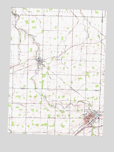
Bluffton, OH USGS Topographic Map
Click on map above to begin viewing in our Map Viewer.

This topographic map contains these locations and features:
Feature Name Type Latitude Longitude GNIS ID View Map
Augsburger FarmsLocaleN40.9458°W83.9164°2564644View Map
Bassinger DitchCanalN40.9564°W83.9269°1037671View Map
BlufftonPopulated PlaceN40.8953°W83.8888°1064461View Map
Bluffton CollegeSchoolN40.8956°W83.8983°1060888View Map
Bluffton College LakeReservoirN40.9045°W83.9086°1078539View Map
Bluffton College Lake DamDamN40.9051°W83.9083°1078538View Map
Bluffton Elementary SchoolSchoolN40.8945°W83.8930°1049715View Map
Bluffton Emergency Medical ServicesBuildingN40.8957°W83.8877°2550853View Map
Bluffton Fire DepartmentBuildingN40.8959°W83.8881°2550205View Map
Bluffton High SchoolSchoolN40.8926°W83.8936°1049716View Map
Bluffton HospitalHospitalN40.8875°W83.8974°1063527View Map
Bluffton Police DepartmentBuildingN40.8943°W83.8903°2733037View Map
Bluffton Post OfficePost OfficeN40.8928°W83.8927°1082342View Map
Bluffton Town HallBuildingN40.8942°W83.8902°1700909View Map
Bluffton-Richland Public LibraryBuildingN40.8923°W83.8930°1807011View Map
Buckeye LakeReservoirN40.8988°W83.8882°1038475View Map
Cartwright RunStreamN40.9931°W83.9038°1038850View Map
College HallBuildingN40.8953°W83.8994°1700910View Map
Cranberry RunStreamN40.9781°W83.9902°1039444View Map
Ebenezer CemeteryCemeteryN40.8925°W83.9380°1699309View Map
Ebenezer ChurchChurchN40.8920°W83.9374°1040059View Map
First Evangelical Lutheran ChurchChurchN40.8917°W83.8955°1700911View Map
First Mennonite ChurchChurchN40.8939°W83.8927°1700912View Map
First Methodist Episcopal ChurchChurchN40.8942°W83.8924°1700913View Map
First Presbyterian ChurchChurchN40.8934°W83.8913°1700914View Map
Hillsville School (historical)SchoolN40.8912°W83.9622°1049714View Map
Hilty CemeteryCemeteryN40.9522°W83.9697°1041608View Map
Interchange 140CrossingN40.8823°W83.8999°1080281View Map
Johime - Mennonite CemeteryCemeteryN40.9495°W83.9391°1071348View Map
Lincoln HallBuildingN40.8967°W83.8988°1700915View Map
Little Riley CreekStreamN40.9001°W83.8913°1042685View Map
Luginbill Swine FarmsLocaleN40.9764°W83.9219°2564633View Map
Maple Grove CemeteryCemeteryN40.8931°W83.9033°1699314View Map
Maple Ridge FarmsLocaleN40.9350°W83.9803°2585733View Map
Marsh RunStreamN40.8976°W83.8866°1043015View Map
Mennonite ChurchChurchN40.9087°W83.9366°1043225View Map
Musselman LibraryBuildingN40.8948°W83.8994°1700916View Map
Ohio Dusting Company Inc AirportAirportN40.9533°W83.9770°1082940View Map
Old Mennonite CemeteryCemeteryN40.9062°W83.9377°1699317View Map
PandoraPopulated PlaceN40.9481°W83.9611°1085224View Map
Pandora CemeteryCemeteryN40.9437°W83.9626°1071353View Map
Pandora Emergency Medical ServicesBuildingN40.9478°W83.9624°2551012View Map
Pandora Police DepartmentBuildingN40.9479°W83.9622°2732459View Map
Pandora Post OfficePost OfficeN40.9487°W83.9611°2043383View Map
Pandora-Gilboa High SchoolSchoolN40.9503°W83.9630°1050111View Map
Pleasant Ridge CemeteryCemeteryN40.9523°W83.9427°1044571View Map
Reformed Mennonite CemeteryCemeteryN40.9050°W83.9380°1699320View Map
Riley Creek CemeteryCemeteryN40.9934°W83.9980°1071354View Map
Riley Creek ChurchChurchN40.9928°W83.9977°1070914View Map
Riley Township Fire DepartmentBuildingN40.9469°W83.9617°2549653View Map
Ropp HallBuildingN40.8939°W83.8977°1700917View Map
Saint Johns ChurchChurchN40.9495°W83.9386°1071356View Map
Saint Johns Reformed ChurchChurchN40.8928°W83.8949°1700918View Map
Saint Marys Roman Catholic ChurchChurchN40.8962°W83.8924°1700919View Map
Schulte FarmsLocaleN40.9517°W83.9258°2564634View Map
Shannon CemeteryCemeteryN40.8942°W83.8877°1699326View Map
Spring Lake VillagePopulated PlaceN40.9358°W83.9622°2648349View Map
Township of RileyCivilN40.9566°W83.9380°1086868View Map
Village of BlufftonCivilN40.8912°W83.8886°2398144View Map
Village of PandoraCivilN40.9481°W83.9588°2399619View Map
WQTL-FM (Ottawa)TowerN40.9559°W83.9116°1085395View Map
Zion CemeteryCemeteryN40.8916°W83.9625°1048259View Map

Note: Coordinates in the location and feature list above are referenced to NAD83 datum.


Copyright (C) 2008-2024 Ryan Niemi / Sunset Dynamics ... All Rights Reserved