TopoQuest Logo
Do you find TopoQuest useful?
Help keep TopoQuest running and adding new maps/features by donating!
Bitcoin:  19c7KJd3qBynnjoSw5npx9KScwjBe4ifkT
Litecoin:  LXs6TkuXGGXo1vDsWCkWVdjQX94eUKd6ui
Home View Maps Find Maps Find Places Resources & Links


Locke, Tennessee Topographic Map

USGS Map Title: Locke, TN
USGS Map MRC: 35090C1
DRG (GeoTIFF) Download: o35090c1.tif


Neighboring USGS Topographic Map Quads:


  Frenchmans Bayou, AR  
35090D2
 

  Pecan Point, AR  
35090D1
 

  Drummonds, TN  
35089D8
 

  Jericho, AR  
35090C2
 

  Locke, TN  
35090C1
 

  Millington, TN  
35089C8
 

  West Memphis, AR  
35090B2
 

  Northwest Memphis, TN  
35090B1
 

  Northeast Memphis, TN  
35089B8


Map MRC Location:

N36°
W91°
N36°
W90°
H8 H7 H6 H5 H4 H3 H2 H1
G8 G7 G6 G5 G4 G3 G2 G1
F8 F7 F6 F5 F4 F3 F2 F1
E8 E7 E6 E5 E4 E3 E2 E1
D8 D7 D6 D5 D4 D3 D2 D1
C8 C7 C6 C5 C4 C3 C2 C1
B8 B7 B6 B5 B4 B3 B2 B1
A8 A7 A6 A5 A4 A3 A2 A1
N35°
W91°
N35°
W90°

Locke, TN USGS 1:24K Topographic Map Preview:
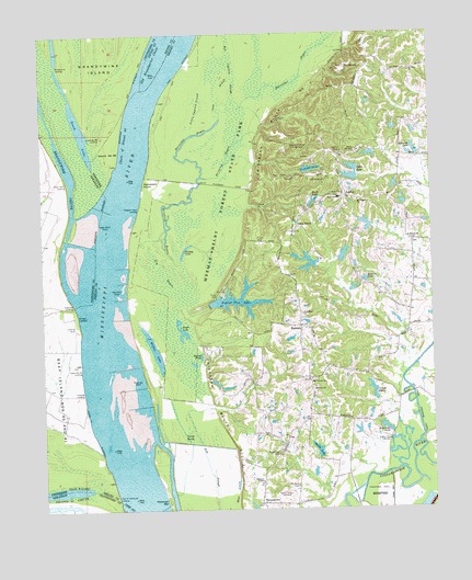
Locke, TN USGS Topographic Map
Click on map above to begin viewing in our Map Viewer.

This topographic map contains these locations and features:
Feature Name Type Latitude Longitude GNIS ID View Map
Barnishee BayouLakeN35.3312°W90.0768°1304968View Map
Bateman PointCapeN35.3573°W90.0868°1313559View Map
BenjestownPopulated PlaceN35.2518°W90.0554°1305101View Map
Benjestown CemeteryCemeteryN35.2648°W90.0498°1277006View Map
Benjestown School (historical)SchoolN35.2687°W90.0473°1325458View Map
Big CreekStreamN35.2676°W90.0048°1277276View Map
Big Cypress SloughGutN35.3659°W90.0626°1277286View Map
Brandywine LandingLocaleN35.3668°W90.1195°57429View Map
Brandywine RevetmentCanalN35.3568°W90.0970°79118View Map
Brinkley BayouStreamN35.3148°W90.0806°1278402View Map
Bullpen LandingLocaleN35.3012°W90.1134°1314768View Map
Camp HaiyakaLocaleN35.3443°W90.0229°1279393View Map
Camp Haiyaka DamDamN35.3434°W90.0184°1301763View Map
Camp Haiyaka LakeReservoirN35.3432°W90.0195°1301762View Map
Camp Lake Number OneReservoirN35.2801°W90.0201°1301719View Map
Camp Lake Number One DamDamN35.2801°W90.0201°1301718View Map
Camps LakesReservoirN35.2795°W90.0188°1279484View Map
Chase Lake Number OneReservoirN35.3124°W90.0396°1301739View Map
Chase Lake Number One DamDamN35.3134°W90.0384°1301738View Map
Chase Lake Number ThreeReservoirN35.2984°W90.0301°1301731View Map
Chase Lake Number Three DamDamN35.2984°W90.0301°1301730View Map
Chase Lake Number TwoReservoirN35.3151°W90.0434°1301740View Map
Chase Lake Number Two DamDamN35.3151°W90.0434°1301741View Map
Chickasaw Bluff Number ThreeCliffN35.3201°W90.0601°1314086View Map
Chute of Island Thirty-nineChannelN35.3468°W90.0973°1280558View Map
Cigarette LandingLocaleN35.3045°W90.1154°57551View Map
Dogwood Ridge CampgroundLocaleN35.3465°W90.0437°1282614View Map
Drane LakeReservoirN35.2655°W90.0373°1282781View Map
Dry BayouSwampN35.3010°W90.0825°1282819View Map
E E Jeter Elementary SchoolSchoolN35.3318°W90.0295°1648392View Map
Eagle LakeLakeN35.2967°W90.0803°1283296View Map
Easthams Landing (historical)LocaleN35.3179°W90.0973°1325597View Map
Elliots LandingLocaleN35.2726°W90.1106°1325607View Map
Foot of Island Forty LandingLocaleN35.2540°W90.1015°1315066View Map
Forestview Church of ChristChurchN35.2741°W90.0269°2425173View Map
Giles TownPopulated PlaceN35.3245°W90.0431°1306481View Map
Grace Community ChurchChurchN35.2797°W90.0012°2425199View Map
Grassy LakeLakeN35.3181°W90.0792°1285903View Map
Gum SloughGutN35.3598°W90.0670°1286411View Map
Hickman BarBarN35.2523°W90.0851°1287547View Map
Howards LandingLocaleN35.2815°W90.1112°1315268View Map
Island 40 ChuteGutN35.2554°W90.1101°50529View Map
Island Forty CemeteryCemeteryN35.2881°W90.1140°1325808View Map
Island Number 39 LandingLocaleN35.3479°W90.1095°82453View Map
Island Number Forty LandingLocaleN35.2873°W90.1126°1315289View Map
Island Number Thirty-nineFlatN35.3440°W90.1034°1289098View Map
Jester (historical)Populated PlaceN35.3609°W90.0270°1313626View Map
Little Cypress SloughGutN35.3556°W90.0737°1291469View Map
LockePopulated PlaceN35.3323°W90.0268°1291758View Map
Long PondSwampN35.2710°W90.0811°1291996View Map
Lyle DamDamN35.3384°W90.0234°1301757View Map
Lyle LakeReservoirN35.3384°W90.0234°1301756View Map
Lyles LakeLakeN35.3373°W90.0260°1292330View Map
Marie LakeLakeN35.3308°W90.0378°1292682View Map
Marie Lake DamDamN35.3301°W90.0368°1301749View Map
McAlexander Lake Number OneReservoirN35.2834°W90.0700°1301721View Map
McAlexander Lake Number One DamDamN35.2834°W90.0718°1301720View Map
Meeman-Shelby Forest State ParkParkN35.3337°W90.0684°1306741View Map
Mount Pisgah CemeteryCemeteryN35.3312°W90.0245°1325220View Map
Mount Pisgah ChurchChurchN35.3309°W90.0231°1294738View Map
Mount Vernon CemeteryCemeteryN35.2840°W90.0387°1325228View Map
Mount Vernon ChurchChurchN35.2843°W90.0384°1306790View Map
New Hope ChurchChurchN35.3018°W90.0415°1295522View Map
New Testament Gospel Christian ChurchChurchN35.2557°W90.0336°2425658View Map
NorthavenPopulated PlaceN35.2668°W90.0484°1313548View Map
Northaven Elementary SchoolSchoolN35.2658°W90.0423°2425482View Map
OaklawnPopulated PlaceN35.2843°W90.0401°1647725View Map
Oaklawn ChurchChurchN35.2829°W90.0373°1306852View Map
Old Brandywine ChuteChannelN35.3718°W90.0843°1296280View Map
Piersol LakeReservoirN35.3394°W90.0388°1301758View Map
Piersol LakeLakeN35.3395°W90.0384°1297431View Map
Piersol Lake DamDamN35.3384°W90.0418°1301759View Map
Pleasant ChapelChurchN35.2576°W90.0545°1306901View Map
Pleasant View LandingLocaleN35.3293°W90.0934°1315745View Map
Poker PointCapeN35.3351°W90.1165°59251View Map
Poker Point DikesLeveeN35.3293°W90.1040°1298018View Map
Poker Point DikesLeveeN35.3298°W90.1062°53653View Map
Poker Point LandingLocaleN35.3362°W90.1168°58406View Map
Poplar Tree LakeReservoirN35.3050°W90.0624°1306911View Map
Poplar Tree Lake DamDamN35.3037°W90.0715°1307095View Map
RamseyPopulated PlaceN35.2984°W90.0418°1298881View Map
Randolph DikesLeveeN35.3006°W90.1004°1306939View Map
Randolph PointCapeN35.3362°W90.0918°1298906View Map
Randolph Point BarBarN35.2743°W90.0984°1313532View Map
Rebecca LakeReservoirN35.3103°W90.0215°1299024View Map
Robertson LakeLakeN35.2715°W90.0156°1299674View Map
Robertson Lake DamDamN35.2701°W90.0134°1301706View Map
Round PondLakeN35.2903°W90.0746°1300172View Map
Saint Matthew CemeteryCemeteryN35.3201°W90.0054°1324981View Map
Saint Matthews ChurchChurchN35.3206°W90.0054°1307007View Map
Saint Paul CemeteryCemeteryN35.3659°W90.0059°1324985View Map
Saint Paul Church (historical)ChurchN35.2712°W90.0448°1324987View Map
Saint Paul School (historical)SchoolN35.3654°W90.0054°1324988View Map
Saint Pauls CemeteryCemeteryN35.2562°W90.0437°1307010View Map
Saint Pauls ChurchChurchN35.3651°W90.0068°1307014View Map
Shelby County Fire Department Station 67BuildingN35.2624°W90.0343°2654017View Map
Shelby Forest Division (historical)CensusN35.2918°W90.0184°1648958View Map
Shelby Forest RevetmentLeveeN35.3709°W90.0751°1313537View Map
Shoemaker-Shelby Forest AirportAirportN35.3175°W90.0352°2444018View Map
South LakeLakeN35.3515°W90.1131°75136View Map
Too Lazy To Farm DamDamN35.3440°W90.0043°1307103View Map
Too Lazy To Farm LakeReservoirN35.3442°W90.0051°1283561View Map
WDIA-AM (Memphis)TowerN35.2681°W90.0176°1639846View Map
WHBQ-AM (Memphis)TowerN35.2534°W90.0476°1639842View Map
Willow LakeLakeN35.2922°W90.0896°1274763View Map

Note: Coordinates in the location and feature list above are referenced to NAD83 datum.


Copyright (C) 2008-2024 Ryan Niemi / Sunset Dynamics ... All Rights Reserved