TopoQuest Logo
Do you find TopoQuest useful?
Help keep TopoQuest running and adding new maps/features by donating!
Bitcoin:  19c7KJd3qBynnjoSw5npx9KScwjBe4ifkT
Litecoin:  LXs6TkuXGGXo1vDsWCkWVdjQX94eUKd6ui
Home View Maps Find Maps Find Places Resources & Links


Frenchmans Bayou, Arkansas Topographic Map

USGS Map Title: Frenchmans Bayou, AR
USGS Map MRC: 35090D2
DRG (GeoTIFF) Download: o35090d2.tif


Neighboring USGS Topographic Map Quads:


  Lepanto, AR  
35090E3
 

  Joiner, AR  
35090E2
 

  Wilson, AR  
35090E1
 

  Tyronza, AR  
35090D3
 

  Frenchmans Bayou, AR  
35090D2
 

  Pecan Point, AR  
35090D1
 

  Heafer, AR  
35090C3
 

  Jericho, AR  
35090C2
 

  Locke, TN  
35090C1


Map MRC Location:

N36°
W91°
N36°
W90°
H8 H7 H6 H5 H4 H3 H2 H1
G8 G7 G6 G5 G4 G3 G2 G1
F8 F7 F6 F5 F4 F3 F2 F1
E8 E7 E6 E5 E4 E3 E2 E1
D8 D7 D6 D5 D4 D3 D2 D1
C8 C7 C6 C5 C4 C3 C2 C1
B8 B7 B6 B5 B4 B3 B2 B1
A8 A7 A6 A5 A4 A3 A2 A1
N35°
W91°
N35°
W90°

Frenchmans Bayou, AR USGS 1:24K Topographic Map Preview:
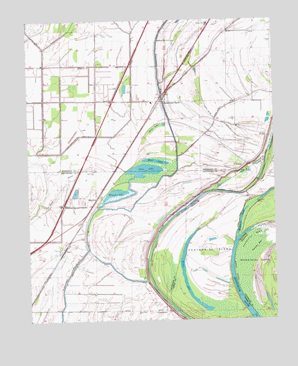
Frenchmans Bayou, AR USGS Topographic Map
Click on map above to begin viewing in our Map Viewer.

This topographic map contains these locations and features:
Feature Name Type Latitude Longitude GNIS ID View Map
Barney ChuteStreamN35.3754°W90.1376°76238View Map
Bellhammer SloughStreamN35.4048°W90.2201°46367View Map
Brandywine ChuteGutN35.3751°W90.1356°1305395View Map
Brandywine PointCapeN35.4006°W90.1465°1644835View Map
Centennial BendBendN35.4076°W90.1384°47626View Map
Centennial IslandFlatN35.4251°W90.1418°1269436View Map
Chapman Switch (historical)LocaleN35.4398°W90.2043°61993View Map
Chute 38StreamN35.3912°W90.1912°47787View Map
Devils ElbowBendN35.4031°W90.1876°48487View Map
Ditch Number 1CanalN35.4520°W90.2198°82028View Map
Ditch Number 11CanalN35.4526°W90.1456°82052View Map
Ditch Number 14CanalN35.4623°W90.1590°82079View Map
Ditch Number 15CanalN35.4998°W90.2045°82094View Map
Ditch Number 2CanalN35.4629°W90.1515°82135View Map
Ditch Number 2CanalN35.4729°W90.2151°82136View Map
Ditch Number 3CanalN35.4865°W90.1573°81950View Map
Ditch Number 4CanalN35.4890°W90.1765°82246View Map
Ditch Number 4CanalN35.4762°W90.2418°82251View Map
Frenchmans BayouPopulated PlaceN35.4662°W90.1809°76978View Map
Frenchmans BayouStreamN35.4576°W90.1781°49245View Map
Frenchmans Bayou Post OfficePost OfficeN35.4676°W90.1832°2773504View Map
Happy Valley LandingLocaleN35.4262°W90.1348°1315185View Map
Happy Valley RevetmentLeveeN35.4226°W90.1401°1286785View Map
KPYR-FM (Osceola)TowerN35.4676°W90.1909°85415View Map
Lake Grove ChurchChurchN35.4373°W90.2170°50945View Map
LambethvillePopulated PlaceN35.3787°W90.1815°58043View Map
Massey BarBarN35.4048°W90.1343°51733View Map
McKenzie ChuteStreamN35.4095°W90.1437°1293362View Map
MenesheaPopulated PlaceN35.4265°W90.2145°58164View Map
Meneshea LakeLakeN35.4280°W90.2049°77647View Map
Meneshea School (historical)SchoolN35.4154°W90.2240°59246View Map
Mink LakeLakeN35.4413°W90.1851°75025View Map
Mount Zion Church (historical)ChurchN35.4040°W90.2293°70242View Map
Peach BayouGutN35.4629°W90.1512°61994View Map
Rasts LandingLocaleN35.3787°W90.1284°58461View Map
Rupe CemeteryCemeteryN35.4376°W90.1634°59399View Map
Saint Francis LeveeLeveeN35.4284°W90.1401°1300433View Map
Saint Pauls ChurchChurchN35.4587°W90.1448°78266View Map
Saint ThomasPopulated PlaceN35.4420°W90.1429°58572View Map
Saint Thomas (historical)Populated PlaceN35.4323°W90.1718°67825View Map
Saint Thomas Church (historical)ChurchN35.4326°W90.1729°59245View Map
Sam Barr Lake (historical)LakeN35.4476°W90.2420°61992View Map
Shawnee Elementary SchoolSchoolN35.4984°W90.1584°83505View Map
Sims (historical)Populated PlaceN35.4959°W90.2420°70095View Map
StacyPopulated PlaceN35.4045°W90.2326°58676View Map
Stave LakeLakeN35.4376°W90.1912°78451View Map
Swan LakeLakeN35.4568°W90.1809°75158View Map
Township of FoglemanCivilN35.3910°W90.2278°68747View Map
Township of McGavockCivilN35.4833°W90.1398°69664View Map
Township of Old River (historical)CivilN35.3876°W90.2084°67812View Map
Turrell Flying Service AirportAirportN35.3785°W90.1977°83849View Map
Union Grove ChurchChurchN35.3781°W90.1951°55816View Map
Willow LakeLakeN35.3875°W90.1697°1274764View Map

Note: Coordinates in the location and feature list above are referenced to NAD83 datum.


Copyright (C) 2008-2024 Ryan Niemi / Sunset Dynamics ... All Rights Reserved