TopoQuest Logo
Do you find TopoQuest useful?
Help keep TopoQuest running and adding new maps/features by donating!
Bitcoin:  19c7KJd3qBynnjoSw5npx9KScwjBe4ifkT
Litecoin:  LXs6TkuXGGXo1vDsWCkWVdjQX94eUKd6ui
Home View Maps Find Maps Find Places Resources & Links


Loudon, Tennessee Topographic Map

USGS Map Title: Loudon, TN
USGS Map MRC: 35084F3
DRG (GeoTIFF) Download: o35084f3.tif


Neighboring USGS Topographic Map Quads:


  Cave Creek, TN  
35084G4
 

  Lenoir City, TN  
35084G3
 

  Concord, TN  
35084G2
 

  Philadelphia, TN  
35084F4
 

  Loudon, TN  
35084F3
 

  Meadow, TN  
35084F2
 

  Sweetwater, TN  
35084E4
 

  Madisonville, TN  
35084E3
 

  Vonore, TN  
35084E2


Map MRC Location:

N36°
W85°
N36°
W84°
H8 H7 H6 H5 H4 H3 H2 H1
G8 G7 G6 G5 G4 G3 G2 G1
F8 F7 F6 F5 F4 F3 F2 F1
E8 E7 E6 E5 E4 E3 E2 E1
D8 D7 D6 D5 D4 D3 D2 D1
C8 C7 C6 C5 C4 C3 C2 C1
B8 B7 B6 B5 B4 B3 B2 B1
A8 A7 A6 A5 A4 A3 A2 A1
N35°
W85°
N35°
W84°

Loudon, TN USGS 1:24K Topographic Map Preview:
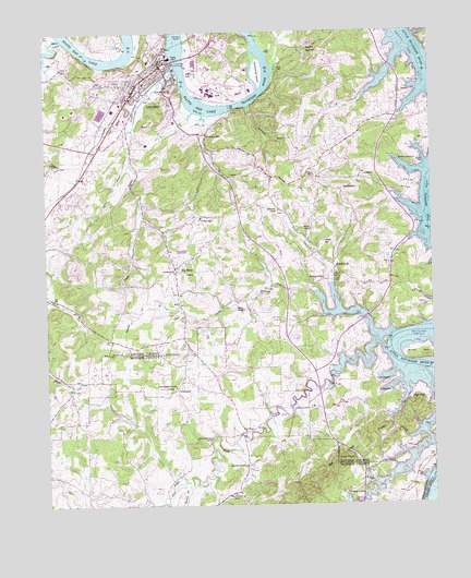
Loudon, TN USGS Topographic Map
Click on map above to begin viewing in our Map Viewer.

This topographic map contains these locations and features:
Feature Name Type Latitude Longitude GNIS ID View Map
Andersons Ferry (historical)LocaleN35.7479°W84.3660°1643251View Map
Bacon HospitalHospitalN35.7348°W84.3341°1304912View Map
Bat CreekStreamN35.6606°W84.2535°1304990View Map
Bethel ChurchChurchN35.6754°W84.2713°1305135View Map
Big PineyPopulated PlaceN35.6876°W84.3333°1277355View Map
Blair BendBendN35.7367°W84.3158°1277634View Map
Blair Bend Industrial ParkLocaleN35.7373°W84.3152°1309513View Map
Blair BluffCliffN35.7298°W84.3113°1309514View Map
Blairs Ferry (historical)LocaleN35.7417°W84.3308°1643254View Map
Blankenship ShoalsBarN35.6626°W84.2610°1643255View Map
Bowman CemeteryCemeteryN35.7158°W84.2548°1305362View Map
Bowman Church (historical)ChurchN35.7106°W84.2566°1309618View Map
Briar RidgeRidgeN35.7409°W84.2752°1309515View Map
Burton BranchStreamN35.6298°W84.3302°1279126View Map
Burton MillPopulated PlaceN35.6709°W84.2694°1279135View Map
Carmichael Inn MuseumBuildingN35.7409°W84.3371°1643268View Map
Carmichael IslandIslandN35.7395°W84.3060°1305689View Map
Cemetery Union ChurchChurchN35.6509°W84.2621°1280112View Map
Clear Creek Recreation AreaParkN35.6715°W84.2721°1309522View Map
Clear ProngStreamN35.6687°W84.2688°1280678View Map
Clemmer CemeteryCemeteryN35.6284°W84.2774°1280696View Map
Coffman CemeteryCemeteryN35.6656°W84.2682°1309523View Map
Commissioner District 1CivilN35.7345°W84.3560°2464258View Map
Commissioner District 7CivilN35.7055°W84.2635°2464039View Map
Corinth ChurchChurchN35.6865°W84.3335°1306113View Map
Cumberland Stand ChurchChurchN35.6429°W84.3219°1281842View Map
DavisPopulated PlaceN35.7331°W84.2533°1314933View Map
Davis CemeteryCemeteryN35.7337°W84.2555°1309528View Map
Davis SchoolSchoolN35.7117°W84.2902°1282206View Map
Eve MillsPopulated PlaceN35.6440°W84.3124°1315030View Map
Everett SchoolSchoolN35.6554°W84.3341°1283921View Map
First Baptist ChurchChurchN35.7412°W84.3385°1643276View Map
Fork CreekStreamN35.6654°W84.2652°1284618View Map
Fort Loudoun Middle SchoolSchoolN35.7204°W84.3421°1309532View Map
Hays Memorial ChurchChurchN35.6279°W84.3152°1287248View Map
Hickman CemeteryCemeteryN35.6978°W84.2788°1309540View Map
High TopSummitN35.6520°W84.2555°1287722View Map
Huff Ferry (historical)LocaleN35.7459°W84.3471°1309539View Map
Jackson BendBendN35.6656°W84.2563°1289183View Map
Jackson SchoolSchoolN35.6701°W84.2691°1289245View Map
LIttle ValleyValleyN35.7448°W84.2593°1309556View Map
LoudonPopulated PlaceN35.7329°W84.3338°1292101View Map
Loudon BridgeBridgeN35.7429°W84.3319°1292102View Map
Loudon Church of the NazareneChurchN35.7404°W84.3358°1643294View Map
Loudon City HallBuildingN35.7434°W84.3363°1643291View Map
Loudon CountyCivilN35.7348°W84.3119°1639767View Map
Loudon County CourthouseBuildingN35.7409°W84.3369°1643287View Map
Loudon County Fire Rescue Station 4BuildingN35.7132°W84.2889°2654981View Map
Loudon Cumberland Presbyterian ChurchChurchN35.7412°W84.3391°1643293View Map
Loudon Division (historical)CensusN35.7231°W84.3346°1648837View Map
Loudon Elementary SchoolSchoolN35.7367°W84.3424°1309554View Map
Loudon Fire Department Station 1BuildingN35.7419°W84.3340°2654369View Map
Loudon High SchoolSchoolN35.7270°W84.3508°1309552View Map
Loudon Junior High SchoolSchoolN35.7404°W84.3438°1309553View Map
Loudon Marine ParkParkN35.7376°W84.3296°1309555View Map
Loudon Police Department HeadquartersBuildingN35.7419°W84.3339°2766051View Map
Loudon Post OfficePost OfficeN35.7440°W84.3365°1649969View Map
Loudon United Methodist ChurchChurchN35.7395°W84.3388°1643292View Map
Lower Coytee ShoalsBarN35.7454°W84.2541°1643288View Map
MacedoniaPopulated PlaceN35.6559°W84.3333°1310126View Map
Maple SpringSpringN35.6856°W84.2819°1292630View Map
Maple SpringPopulated PlaceN35.6920°W84.2874°1309621View Map
Markwood Chapel School (historical)SchoolN35.6759°W84.3099°1309622View Map
McKee CemeteryCemeteryN35.6882°W84.3009°1309575View Map
Mount Olive Baptist ChurchChurchN35.7387°W84.3377°1643299View Map
Mount Zion Baptist ChurchChurchN35.7126°W84.2721°1294886View Map
New Macedonia ChurchChurchN35.6562°W84.3338°1295597View Map
New Union Fork ChurchChurchN35.6731°W84.2988°1309583View Map
Poplar SpringsPopulated PlaceN35.7456°W84.2921°1298232View Map
Poplar Springs Baptist ChurchChurchN35.7476°W84.2869°1643306View Map
Poplar Springs RidgeRidgeN35.7445°W84.2860°1309589View Map
Poplar Springs School (historical)SchoolN35.7470°W84.2877°1322674View Map
Robertson CemeteryCemeteryN35.6353°W84.3119°1299663View Map
Robinson MillPopulated PlaceN35.7229°W84.3224°1315822View Map
Roy White DamDamN35.6751°W84.3233°1302030View Map
Roy White LakeReservoirN35.6751°W84.3233°1302031View Map
Russell CemeteryCemeteryN35.6573°W84.2638°1300309View Map
Russell StoreLocaleN35.6876°W84.2819°1300349View Map
Simpson CemeteryCemeteryN35.6982°W84.2917°1270336View Map
Steaky School (historical)SchoolN35.7009°W84.3435°1309626View Map
Steekee CreekStreamN35.7404°W84.3319°1303813View Map
Steekee Elementary SchoolSchoolN35.7012°W84.3246°1648165View Map
Sweetwater CreekStreamN35.7487°W84.3691°1303972View Map
Sycamore BranchStreamN35.7304°W84.3088°1271998View Map
Sycamore HollowValleyN35.7373°W84.3010°1309603View Map
Tellico Village Census Designated PlaceCensusN35.6978°W84.2661°2584594View Map
Tellico Village Volunteer Fire DepartmentBuildingN35.6954°W84.2630°2654596View Map
Terry KnobSummitN35.6365°W84.2802°1272343View Map
Toliver IslandIslandN35.7017°W84.2502°1272727View Map
Tulagalla School (historical)SchoolN35.6373°W84.3102°1310127View Map
Upper Coutee ShoalsBarN35.7106°W84.2508°1643324View Map
Valley View ChurchChurchN35.7029°W84.2996°1304287View Map
Watkins CemeteryCemeteryN35.6848°W84.2849°1304316View Map
Watson CemeteryCemeteryN35.6770°W84.3144°1273920View Map
Watts CemeteryCemeteryN35.7084°W84.2785°1273946View Map
Williams BranchStreamN35.7154°W84.3477°1274627View Map
Williams HollowValleyN35.6883°W84.2816°1309613View Map
Winding ShoalsBarN35.7284°W84.3208°1643328View Map
WLNT-AM (Loudon)TowerN35.7265°W84.3469°1639885View Map

Note: Coordinates in the location and feature list above are referenced to NAD83 datum.


Copyright (C) 2008-2024 Ryan Niemi / Sunset Dynamics ... All Rights Reserved