TopoQuest Logo
Do you find TopoQuest useful?
Help keep TopoQuest running and adding new maps/features by donating!
Bitcoin:  19c7KJd3qBynnjoSw5npx9KScwjBe4ifkT
Litecoin:  LXs6TkuXGGXo1vDsWCkWVdjQX94eUKd6ui
Home View Maps Find Maps Find Places Resources & Links


Lyles, Tennessee Topographic Map

USGS Map Title: Lyles, TN
USGS Map MRC: 35087H3
DRG (GeoTIFF) Download: o35087h3.tif


Neighboring USGS Topographic Map Quads:


  Dickson, TN  
36087A4
 

  Burns, TN  
36087A3
 

  White Bluff, TN  
36087A2
 

  Texas Hollow, TN  
35087H4
 

  Lyles, TN  
35087H3
 

  Craigfield, TN  
35087H2
 

  Centerville, TN  
35087G4
 

  Littlelot, TN  
35087G3
 

  Primm Springs, TN  
35087G2


Map MRC Location:

N36°
W88°
N36°
W87°
H8 H7 H6 H5 H4 H3 H2 H1
G8 G7 G6 G5 G4 G3 G2 G1
F8 F7 F6 F5 F4 F3 F2 F1
E8 E7 E6 E5 E4 E3 E2 E1
D8 D7 D6 D5 D4 D3 D2 D1
C8 C7 C6 C5 C4 C3 C2 C1
B8 B7 B6 B5 B4 B3 B2 B1
A8 A7 A6 A5 A4 A3 A2 A1
N35°
W88°
N35°
W87°

Lyles, TN USGS 1:24K Topographic Map Preview:
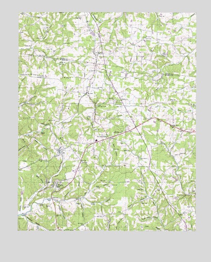
Lyles, TN USGS Topographic Map
Click on map above to begin viewing in our Map Viewer.

This topographic map contains these locations and features:
Feature Name Type Latitude Longitude GNIS ID View Map
AbiffPopulated PlaceN35.9762°W87.3175°1314559View Map
Anderson BranchStreamN35.8926°W87.3422°1275685View Map
Andy HollowValleyN35.8781°W87.3611°1275754View Map
Baird CemeteryCemeteryN35.9037°W87.3131°1276123View Map
Baker HollowValleyN35.9296°W87.3683°1276180View Map
Baker Hollow ProspectMineN35.9228°W87.3628°1319044View Map
Bartley CemeteryCemeteryN35.8901°W87.3592°1276407View Map
BatesPopulated PlaceN35.9101°W87.3745°1314633View Map
Bear Creek Freewill Baptist ChurchChurchN35.9815°W87.3428°1305018View Map
Bob HollowValleyN35.9709°W87.2661°1277860View Map
Bon AquaPopulated PlaceN35.9534°W87.3270°1305340View Map
Bon Aqua ChurchChurchN35.9565°W87.3186°1277923View Map
Bon Aqua ChurchChurchN35.9665°W87.3206°1277924View Map
Bon Aqua JunctionPopulated PlaceN35.9278°W87.3108°1277925View Map
Bon Aqua Junction Census Designated PlaceCensusN35.9281°W87.3124°2584572View Map
Bon Aqua Lookout TowerTowerN35.9312°W87.3031°1647762View Map
Bon Aqua Post OfficePost OfficeN35.9552°W87.3058°1651152View Map
Bon Aqua School (historical)SchoolN35.9506°W87.3231°1319051View Map
Bon Aqua SpringsSpringN35.9468°W87.3188°1277926View Map
Bradford HollowValleyN35.8866°W87.3725°1278168View Map
Bristol Cave BranchStreamN35.9437°W87.3211°1278414View Map
Brown CemeteryCemeteryN35.8909°W87.2881°1278544View Map
Brown HillSummitN35.8951°W87.2772°1278580View Map
Brown HollowValleyN35.8944°W87.2833°1278585View Map
Browns ChapelChurchN35.9853°W87.2811°1305461View Map
Cave HollowValleyN35.8979°W87.3238°1279930View Map
Cave SpringSpringN35.9734°W87.3503°1279951View Map
Cedar Crest Camp LakeReservoirN35.9047°W87.2644°1302203View Map
Cedar Crest Camp Lake DamDamN35.9034°W87.2633°1302202View Map
Cedar Hill CemeteryCemeteryN35.9378°W87.3483°1280067View Map
Clark HollowValleyN35.9004°W87.3565°1280609View Map
Cochran CemeteryCemeteryN35.9014°W87.3092°1280844View Map
Commissioner District 2CivilN35.8832°W87.3642°2463934View Map
Commissioner District 3CivilN35.9433°W87.3638°2464158View Map
Cooper CemeteryCemeteryN35.9253°W87.3006°1281198View Map
Cooper HollowValleyN35.8935°W87.3283°1281213View Map
Dunnagan CemeteryCemeteryN35.9628°W87.3564°1283214View Map
Dunnagan CemeteryCemeteryN35.9712°W87.3408°1283215View Map
East Hickman Elementary SchoolSchoolN35.9266°W87.3198°1319071View Map
Fair View School (historical)SchoolN35.8915°W87.2689°1319072View Map
Fitz Store (historical)LocaleN35.8762°W87.3347°1319075View Map
Frazier CemeteryCemeteryN35.9770°W87.3497°1284855View Map
Frazier School (historical)SchoolN35.9931°W87.3564°1324085View Map
Frith Spring BranchStreamN35.9028°W87.2608°1311353View Map
Goose BranchStreamN35.9370°W87.3461°1285664View Map
Gossett CemeteryCemeteryN35.8909°W87.3311°1285742View Map
Gossett CemeteryCemeteryN35.8942°W87.3506°1285743View Map
Gossett HollowValleyN35.8932°W87.3313°1285745View Map
Grassy HollowValleyN35.9231°W87.3695°1285899View Map
Green CemeteryCemeteryN35.9459°W87.3017°1286080View Map
GrovePopulated PlaceN35.8981°W87.2728°1311354View Map
Grove CemeteryCemeteryN35.8989°W87.2747°1286351View Map
Hickman County Rescue Squad Station 2BuildingN35.9219°W87.3411°2654184View Map
Holland CemeteryCemeteryN35.9806°W87.3658°1288054View Map
Hood CemeteryCemeteryN35.9734°W87.3503°1288227View Map
Hudgins CemeteryCemeteryN35.8989°W87.2867°1288611View Map
Iron HillPopulated PlaceN35.9892°W87.3228°1315285View Map
Iron Hill MineMineN35.9976°W87.3181°1324115View Map
Jenkins CemeteryCemeteryN35.9184°W87.2647°1289346View Map
Jordan CemeteryCemeteryN35.9764°W87.2714°1289835View Map
Little Rock CemeteryCemeteryN35.8889°W87.3706°1291643View Map
Little Rock School (historical)SchoolN35.8890°W87.3664°1319094View Map
Luther CemeteryCemeteryN35.9964°W87.3300°1292308View Map
LylesPopulated PlaceN35.9198°W87.3450°1292325View Map
Lyles CemeteryCemeteryN35.9331°W87.3533°1292326View Map
Lyles Census Designated PlaceCensusN35.9195°W87.3450°2584585View Map
Lyles MineMineN35.9162°W87.3531°1319098View Map
Lyles Post OfficePost OfficeN35.9285°W87.3111°1651174View Map
Lyles ProspectMineN35.9156°W87.3495°1319099View Map
Lyles School (historical)SchoolN35.9223°W87.3436°1319100View Map
Lyles-Wrigley Division (historical)CensusN35.9298°W87.3353°1648785View Map
Martin CemeteryCemeteryN35.8976°W87.2531°1292809View Map
McCord CemeteryCemeteryN35.8820°W87.3700°1293184View Map
McCord CemeteryCemeteryN35.8889°W87.2519°1293185View Map
McCord CemeteryCemeteryN35.9209°W87.2961°1293186View Map
McCoy BranchStreamN35.9281°W87.3736°1293200View Map
Mill CreekPopulated PlaceN35.8848°W87.3689°1311369View Map
Missionary Ridge ChurchChurchN35.9642°W87.3733°1294086View Map
Moss BranchStreamN35.9678°W87.2736°1294495View Map
Nails Creek School (historical)SchoolN35.9987°W87.3014°1324151View Map
New Bethel ChurchChurchN35.8956°W87.2572°1295432View Map
New Hope CemeteryCemeteryN35.9462°W87.2511°1319113View Map
New Hope ChurchChurchN35.9465°W87.2514°1295542View Map
North Fork Bear CreekStreamN35.9790°W87.3653°1295857View Map
North Fork Mill CreekStreamN35.8884°W87.3650°1295902View Map
North Tidwell School (historical)SchoolN35.9523°W87.2597°1319114View Map
Overbey CemeteryCemeteryN35.9192°W87.2569°1296539View Map
Overbey CemeteryCemeteryN35.9495°W87.2683°1296541View Map
Patten ParkParkN35.9145°W87.3303°1296920View Map
PorterPopulated PlaceN35.9842°W87.2775°1298245View Map
Porter CemeteryCemeteryN35.9978°W87.2758°1298256View Map
Porter School (historical)SchoolN35.9859°W87.2820°1324175View Map
Potts CemeteryCemeteryN35.9331°W87.3203°1298368View Map
Potts HollowValleyN35.9424°W87.3303°1298371View Map
Rainey CemeteryCemeteryN35.9589°W87.2747°1298838View Map
Randolph HollowValleyN35.8842°W87.3704°1298905View Map
Register CemeteryCemeteryN35.9992°W87.3461°1299197View Map
Rocky Valley School (historical)SchoolN35.8934°W87.3292°1319125View Map
South Fork Bear CreekStreamN35.9792°W87.3653°1270844View Map
Spring Creek ChurchChurchN35.9395°W87.3667°1271094View Map
Sugar Camp HollowValleyN35.8821°W87.2763°1271648View Map
Tatum ChurchChurchN35.9278°W87.3097°1272174View Map
Tatum School (historical)SchoolN35.9173°W87.2892°1319138View Map
Taylor CemeteryCemeteryN35.9120°W87.3150°1272205View Map
Thornton CemeteryCemeteryN35.8892°W87.3550°1272569View Map
Tidwell CemeteryCemeteryN35.9701°W87.2703°1272623View Map
Tucker CemeteryCemeteryN35.9784°W87.3547°1272949View Map
Vandber HollowValleyN35.8916°W87.3454°1273369View Map
Vineyard CemeteryCemeteryN35.9989°W87.3708°1273472View Map
Ward HollowValleyN35.9128°W87.3086°1273791View Map
Ward SpringSpringN35.9217°W87.3075°1273796View Map
Weems CemeteryCemeteryN35.9401°W87.3231°1274058View Map
Wiley CemeteryCemeteryN35.9848°W87.3622°1274573View Map
Willow Spring CemeteryCemeteryN35.8837°W87.3145°1319150View Map
Willow Spring ChurchChurchN35.8837°W87.3139°1274768View Map
Willow Spring ChurchChurchN35.9167°W87.2889°1274769View Map
WrigleyPopulated PlaceN35.9009°W87.3475°1275191View Map
Wrigley Baptist ChurchChurchN35.9023°W87.3450°1319155View Map
Wrigley Census Designated PlaceCensusN35.8998°W87.3537°2584597View Map
Wrigley Furnace (historical)LocaleN35.9037°W87.3522°1319156View Map
Wrigley ProspectMineN35.9095°W87.3492°1319157View Map
Wrigley SchoolSchoolN35.9081°W87.3575°1275192View Map
Yates CemeteryCemeteryN35.9701°W87.3458°1275247View Map

Note: Coordinates in the location and feature list above are referenced to NAD83 datum.


Copyright (C) 2008-2024 Ryan Niemi / Sunset Dynamics ... All Rights Reserved