TopoQuest Logo
Do you find TopoQuest useful?
Help keep TopoQuest running and adding new maps/features by donating!
Bitcoin:  19c7KJd3qBynnjoSw5npx9KScwjBe4ifkT
Litecoin:  LXs6TkuXGGXo1vDsWCkWVdjQX94eUKd6ui
Home View Maps Find Maps Find Places Resources & Links


Texas Hollow, Tennessee Topographic Map

USGS Map Title: Texas Hollow, TN
USGS Map MRC: 35087H4
DRG (GeoTIFF) Download: o35087h4.tif


Neighboring USGS Topographic Map Quads:


  Tennessee City, TN  
36087A5
 

  Dickson, TN  
36087A4
 

  Burns, TN  
36087A3
 

  Spot, TN  
35087H5
 

  Texas Hollow, TN  
35087H4
 

  Lyles, TN  
35087H3
 

  Whitfield, TN  
35087G5
 

  Centerville, TN  
35087G4
 

  Littlelot, TN  
35087G3


Map MRC Location:

N36°
W88°
N36°
W87°
H8 H7 H6 H5 H4 H3 H2 H1
G8 G7 G6 G5 G4 G3 G2 G1
F8 F7 F6 F5 F4 F3 F2 F1
E8 E7 E6 E5 E4 E3 E2 E1
D8 D7 D6 D5 D4 D3 D2 D1
C8 C7 C6 C5 C4 C3 C2 C1
B8 B7 B6 B5 B4 B3 B2 B1
A8 A7 A6 A5 A4 A3 A2 A1
N35°
W88°
N35°
W87°

Texas Hollow, TN USGS 1:24K Topographic Map Preview:
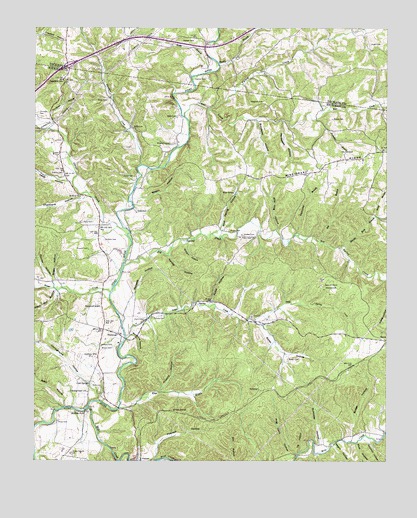
Texas Hollow, TN USGS Topographic Map
Click on map above to begin viewing in our Map Viewer.

This topographic map contains these locations and features:
Feature Name Type Latitude Longitude GNIS ID View Map
Baker CemeteryCemeteryN35.9045°W87.4097°1276154View Map
Baker HollowValleyN35.9153°W87.4218°1276179View Map
Bear CreekStreamN35.9742°W87.4461°1276594View Map
Bear Creek School (historical)SchoolN35.9715°W87.4381°1319046View Map
Beaver CreekStreamN35.9237°W87.4728°1276710View Map
Becky BranchStreamN35.9456°W87.3786°1276749View Map
Bee BranchStreamN35.9384°W87.3986°1276762View Map
Betty HollowValleyN35.8906°W87.4892°1277195View Map
Big Spring CreekStreamN35.9312°W87.4678°1277413View Map
Big Spring Creek School (historical)SchoolN35.9423°W87.4356°1319049View Map
Blue SpringSpringN35.9525°W87.4289°1277787View Map
Blue Spring HollowValleyN35.9418°W87.4342°1277806View Map
Bogle HollowValleyN35.9267°W87.4912°1277875View Map
Boneyard HollowValleyN35.9115°W87.4659°1277949View Map
Booker CemeteryCemeteryN35.9642°W87.3911°1277968View Map
Bridge HollowValleyN35.8884°W87.3855°1278349View Map
Brown CemeteryCemeteryN35.9076°W87.4720°1278546View Map
Brown CemeteryCemeteryN35.9412°W87.4303°1278548View Map
Brown SwitchLocaleN35.8895°W87.4517°1278609View Map
Bruce CemeteryCemeteryN35.9737°W87.3939°1278647View Map
Camp Ground School (historical)SchoolN35.8853°W87.4631°1319053View Map
Campground ChurchChurchN35.8951°W87.4806°1279478View Map
Campground HollowValleyN35.8925°W87.4775°1305653View Map
Cash SpringSpringN35.8975°W87.4807°1279850View Map
Cedar HillSummitN35.9962°W87.4422°1280063View Map
Cedar Hill School (historical)SchoolN35.9967°W87.4431°1324027View Map
Chalkbank HollowValleyN35.9513°W87.4818°1280202View Map
Chappell CemeteryCemeteryN35.9784°W87.4183°1280268View Map
Christian CemeteryCemeteryN35.9753°W87.4989°1280519View Map
Christian HollowValleyN35.9744°W87.4945°1280525View Map
Clark CemeteryCemeteryN35.9159°W87.4608°1280595View Map
Coleman HollowValleyN35.8809°W87.3806°1280953View Map
Dodd CemeteryCemeteryN35.9470°W87.4636°1282553View Map
Double BranchStreamN35.9895°W87.4336°1282684View Map
Dudley CemeteryCemeteryN35.9403°W87.4256°1283061View Map
Garner CreekStreamN35.9423°W87.4686°1306472View Map
Graham CemeteryCemeteryN35.9084°W87.4717°1285800View Map
Graham Post OfficePost OfficeN35.9056°W87.4772°1648560View Map
Griffen HollowValleyN35.9380°W87.4457°1286261View Map
Harberson HollowValleyN35.9733°W87.4120°1286790View Map
Hickory HollowValleyN35.8951°W87.4552°1287608View Map
Hog Joint HollowValleyN35.8767°W87.4072°1287983View Map
Humble CemeteryCemeteryN35.9387°W87.4750°1288696View Map
Humble Church (historical)ChurchN35.9303°W87.4700°1319086View Map
Kansas HollowValleyN35.9346°W87.4522°1289905View Map
Kedron ChurchChurchN35.9512°W87.4836°1289937View Map
Keys BranchStreamN35.8903°W87.4695°1290133View Map
Kirk LakeReservoirN35.9684°W87.4117°1302257View Map
Kirk Lake DamDamN35.9684°W87.4117°1302256View Map
Little Spring CreekStreamN35.9115°W87.4656°1291675View Map
Little Spring Creek School (historical)SchoolN35.9215°W87.4367°1319095View Map
Mack Roy HollowValleyN35.9236°W87.4922°1292447View Map
Martin Fork BranchStreamN35.9365°W87.3914°1292833View Map
Matlock FordPopulated PlaceN35.8892°W87.4814°1315477View Map
McAllister HollowValleyN35.8800°W87.3982°1293072View Map
McCaleb HollowValleyN35.9220°W87.4656°1293097View Map
Meacham CemeteryCemeteryN35.9664°W87.4517°1293477View Map
Mill CreekStreamN35.8903°W87.4808°1293842View Map
Missionary RidgeRidgeN35.9637°W87.3806°1269809View Map
Monk CemeteryCemeteryN35.9789°W87.4739°1294167View Map
Mount Gossett School (historical)SchoolN35.9620°W87.3836°1319110View Map
Mud HollowValleyN35.8804°W87.3852°1295014View Map
Murray HollowValleyN35.9267°W87.4940°1295145View Map
Myatt CemeteryCemeteryN35.9951°W87.3808°1295179View Map
Negro HollowValleyN35.8799°W87.3937°1295345View Map
Peacock HollowValleyN35.8754°W87.4569°1297057View Map
Petty CemeteryCemeteryN35.8956°W87.4764°1297275View Map
Petty CemeteryCemeteryN35.9437°W87.4789°1297276View Map
Petty CemeteryCemeteryN35.9742°W87.4492°1297277View Map
PinewoodPopulated PlaceN35.9115°W87.4697°1315718View Map
Pinewood First Baptist ChurchChurchN35.9115°W87.4706°1319121View Map
Pinewood SchoolSchoolN35.9195°W87.4767°1297607View Map
Pinewood Volunteer Fire DepartmentBuildingN35.9127°W87.4752°2653887View Map
Plunder HollowValleyN35.9604°W87.4622°1313345View Map
Plunders CreekStreamN35.9603°W87.4620°1297984View Map
Plunders Creek School (historical)SchoolN35.9659°W87.4595°1319123View Map
Potter CemeteryCemeteryN35.9395°W87.4222°1298348View Map
Potter HollowValleyN35.9214°W87.4370°1298356View Map
Pumpkin BranchStreamN35.9737°W87.4000°1298673View Map
Redden (historical)Populated PlaceN35.9856°W87.4417°1313347View Map
Redden CemeteryCemeteryN35.9626°W87.4920°1299095View Map
Redden CemeteryCemeteryN35.9853°W87.4383°1299096View Map
Reeves CemeteryCemeteryN35.9581°W87.4897°1299185View Map
RodemerPopulated PlaceN35.8956°W87.4197°1315835View Map
Russell CemeteryCemeteryN35.9359°W87.4806°1300315View Map
Shipp CemeteryCemeteryN35.8864°W87.4917°1270128View Map
Simmons HollowValleyN35.9734°W87.4212°1270320View Map
Smith CemeteryCemeteryN35.9570°W87.4645°1270617View Map
Sugarcamp BranchStreamN35.9406°W87.4067°1271706View Map
Tanbark HillSummitN35.9840°W87.4900°1272074View Map
Temple CemeteryCemeteryN35.9167°W87.4536°1272280View Map
Texas HollowValleyN35.9564°W87.4886°1272352View Map
Tie HollowValleyN35.8776°W87.4061°1272631View Map
Turkey CreekStreamN35.9767°W87.4375°1273012View Map
Wells BranchStreamN35.9870°W87.4378°1274097View Map
Wells CemeteryCemeteryN35.9712°W87.4650°1274105View Map
Western Highland RimAreaN35.9167°W87.4167°1312029View Map
Wild Hog HollowValleyN35.9423°W87.4136°1274527View Map
Wrenn HollowValleyN35.9508°W87.4650°1275148View Map

Note: Coordinates in the location and feature list above are referenced to NAD83 datum.


Copyright (C) 2008-2024 Ryan Niemi / Sunset Dynamics ... All Rights Reserved