TopoQuest Logo
Do you find TopoQuest useful?
Help keep TopoQuest running and adding new maps/features by donating!
Bitcoin:  19c7KJd3qBynnjoSw5npx9KScwjBe4ifkT
Litecoin:  LXs6TkuXGGXo1vDsWCkWVdjQX94eUKd6ui
Home View Maps Find Maps Find Places Resources & Links


Lyons, Kansas Topographic Map

USGS Map Title: Lyons, KS
USGS Map MRC: 38098C2
DRG (GeoTIFF) Download: o38098c2.tif


Neighboring USGS Topographic Map Quads:


  Chase NE, KS  
38098D3
 

  Lyons NW, KS  
38098D2
 

  Little River, KS  
38098D1
 

  Chase, KS  
38098C3
 

  Lyons, KS  
38098C2
 

  Lyons SE, KS  
38098C1
 

  Alden, KS  
38098B3
 

  Sterling, KS  
38098B2
 

  Nickerson, KS  
38098B1


Map MRC Location:

N39°
W99°
N39°
W98°
H8 H7 H6 H5 H4 H3 H2 H1
G8 G7 G6 G5 G4 G3 G2 G1
F8 F7 F6 F5 F4 F3 F2 F1
E8 E7 E6 E5 E4 E3 E2 E1
D8 D7 D6 D5 D4 D3 D2 D1
C8 C7 C6 C5 C4 C3 C2 C1
B8 B7 B6 B5 B4 B3 B2 B1
A8 A7 A6 A5 A4 A3 A2 A1
N38°
W99°
N38°
W98°

Lyons, KS USGS 1:24K Topographic Map Preview:
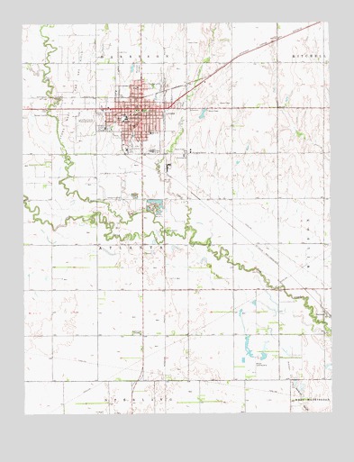
Lyons, KS USGS Topographic Map
Click on map above to begin viewing in our Map Viewer.

This topographic map contains these locations and features:
Feature Name Type Latitude Longitude GNIS ID View Map
Assembly of God ChurchChurchN38.3486°W98.2002°2689297View Map
Camp Wa-Ja-ToLocaleN38.3139°W98.1962°475799View Map
City of LyonsCivilN38.3466°W98.2052°485616View Map
Claytor Chapel African Methodist Episcopal ChurchChurchN38.3549°W98.2029°2689325View Map
Coronado - Quivira MuseumBuildingN38.3457°W98.2038°1967223View Map
Diamond U Stock FarmLocaleN38.2681°W98.1486°2726547View Map
First Baptist ChurchChurchN38.3401°W98.1951°1967229View Map
First Christian ChurchChurchN38.3458°W98.2044°1967228View Map
First Presbyterian ChurchChurchN38.3458°W98.2064°1967231View Map
Frisbie Education CenterSchoolN38.3400°W98.1981°475803View Map
Grace Lutheran ChurchChurchN38.3438°W98.2166°1967225View Map
Grand Shopping CenterLocaleN38.3470°W98.2024°481768View Map
KKAT-FM (Lyons)TowerN38.2758°W98.2034°481493View Map
Little Cow CreekStreamN38.3083°W98.1939°475678View Map
LyonsPopulated PlaceN38.3450°W98.2017°475805View Map
Lyons Central Elementary SchoolSchoolN38.3440°W98.2092°2497424View Map
Lyons Central Elementary SchoolSchoolN38.3440°W98.2092°475802View Map
Lyons Chamber of CommerceBuildingN38.3470°W98.2028°2692821View Map
Lyons Church of ChristChurchN38.3411°W98.2119°2690208View Map
Lyons Church of the NazareneChurchN38.3481°W98.1971°2690385View Map
Lyons City HallBuildingN38.3459°W98.2038°1967232View Map
Lyons Fire DepartmentBuildingN38.3481°W98.1996°2111579View Map
Lyons High SchoolSchoolN38.3342°W98.1978°481168View Map
Lyons Industrial ParkLocaleN38.3528°W98.1991°2692179View Map
Lyons Middle SchoolSchoolN38.3444°W98.2078°481167View Map
Lyons Municipal CemeteryCemeteryN38.3604°W98.2031°2673351View Map
Lyons Park Elementary SchoolSchoolN38.3470°W98.1990°2497361View Map
Lyons Park Elementary SchoolSchoolN38.3470°W98.1990°475800View Map
Lyons Police DepartmentBuildingN38.3480°W98.2000°2504047View Map
Lyons Post OfficePost OfficeN38.3486°W98.2036°1967224View Map
Lyons Public LibraryBuildingN38.3459°W98.2038°1967226View Map
Lyons Town and Country ClubLocaleN38.3357°W98.2041°2694584View Map
Lyons United Methodist ChurchChurchN38.3470°W98.2063°1967230View Map
Lyons Wastewater Treatment FacilityLocaleN38.3192°W98.2108°2693506View Map
Lyons West Oil and Gas FieldOilfieldN38.3500°W98.2303°475674View Map
Lyons-Rice County Municipal AirportAirportN38.3455°W98.2271°475798View Map
North Side School (historical)SchoolN38.3550°W98.2020°1967233View Map
Owl CreekStreamN38.3100°W98.1828°475677View Map
Rice CountyCivilN38.3471°W98.2010°485043View Map
Rice County CourthouseBuildingN38.3472°W98.2040°1967234View Map
Rice County District HospitalHospitalN38.3416°W98.2167°2499067View Map
Rice County Emergency Medical ServicesBuildingN38.3464°W98.2231°2696542View Map
Rice County Health DepartmentBuildingN38.3473°W98.2238°2695054View Map
Rice County JailBuildingN38.3464°W98.2239°2504361View Map
Rice County Public Works DepartmentBuildingN38.3549°W98.2116°2693208View Map
Rice County Sheriff's OfficeBuildingN38.3462°W98.2240°2503982View Map
Saint Mark's Episcopal ChurchChurchN38.3425°W98.2030°2689869View Map
Saint Paul Catholic ChurchChurchN38.3355°W98.2078°1967227View Map
Salt CreekStreamN38.3131°W98.2062°475797View Map
SaxmanPopulated PlaceN38.2806°W98.1259°475806View Map
Shumway Oil FieldOilfieldN38.3272°W98.2128°475804View Map
Team Marketing Alliance Grain Elevator Number 47LocaleN38.2854°W98.1938°2695468View Map
Township of AtlantaCivilN38.3026°W98.2016°475786View Map
Walton Landing Strip (historical)AirportN38.2631°W98.1562°475808View Map
West ParkParkN38.3445°W98.2114°475801View Map

Note: Coordinates in the location and feature list above are referenced to NAD83 datum.


Copyright (C) 2008-2024 Ryan Niemi / Sunset Dynamics ... All Rights Reserved