TopoQuest Logo
Do you find TopoQuest useful?
Help keep TopoQuest running and adding new maps/features by donating!
Bitcoin:  19c7KJd3qBynnjoSw5npx9KScwjBe4ifkT
Litecoin:  LXs6TkuXGGXo1vDsWCkWVdjQX94eUKd6ui
Home View Maps Find Maps Find Places Resources & Links


Sterling, Kansas Topographic Map

USGS Map Title: Sterling, KS
USGS Map MRC: 38098B2
DRG (GeoTIFF) Download: o38098b2.tif


Neighboring USGS Topographic Map Quads:


  Chase, KS  
38098C3
 

  Lyons, KS  
38098C2
 

  Lyons SE, KS  
38098C1
 

  Alden, KS  
38098B3
 

  Sterling, KS  
38098B2
 

  Nickerson, KS  
38098B1
 

  Alden SE, KS  
38098A3
 

  Sterling SW, KS  
38098A2
 

  Yaggy, KS  
38098A1


Map MRC Location:

N39°
W99°
N39°
W98°
H8 H7 H6 H5 H4 H3 H2 H1
G8 G7 G6 G5 G4 G3 G2 G1
F8 F7 F6 F5 F4 F3 F2 F1
E8 E7 E6 E5 E4 E3 E2 E1
D8 D7 D6 D5 D4 D3 D2 D1
C8 C7 C6 C5 C4 C3 C2 C1
B8 B7 B6 B5 B4 B3 B2 B1
A8 A7 A6 A5 A4 A3 A2 A1
N38°
W99°
N38°
W98°

Sterling, KS USGS 1:24K Topographic Map Preview:
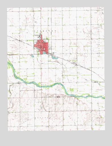
Sterling, KS USGS Topographic Map
Click on map above to begin viewing in our Map Viewer.

This topographic map contains these locations and features:
Feature Name Type Latitude Longitude GNIS ID View Map
Assembly of God ChurchChurchN38.2154°W98.2058°2689299View Map
Bull Creek Oil FieldOilfieldN38.2000°W98.1476°475906View Map
Calvary Baptist ChurchChurchN38.2083°W98.1972°2688614View Map
City of SterlingCivilN38.2091°W98.2067°485654View Map
Dymond Oil FieldOilfieldN38.2242°W98.1406°475907View Map
First Baptist ChurchChurchN38.2097°W98.2081°2690735View Map
First United Methodist ChurchChurchN38.2113°W98.2073°2690892View Map
Peace CreekStreamN38.1745°W98.2295°475893View Map
Reformed Presbyterian ChurchChurchN38.2158°W98.2106°2690784View Map
Santa Fe SloughGutN38.2472°W98.1284°475809View Map
SterlingPopulated PlaceN38.2100°W98.2070°475908View Map
Sterling Airport (historical)AirportN38.2389°W98.2159°475910View Map
Sterling CemeteryCemeteryN38.2189°W98.1991°475909View Map
Sterling Chamber of CommerceBuildingN38.2096°W98.2066°2692632View Map
Sterling City HallBuildingN38.2105°W98.2065°2693076View Map
Sterling CollegeSchoolN38.2200°W98.2077°482714View Map
Sterling Free Public LibraryBuildingN38.2112°W98.2064°2694778View Map
Sterling Grade SchoolSchoolN38.2079°W98.2033°480800View Map
Sterling Grant ChapelChurchN38.2055°W98.2072°2689331View Map
Sterling High SchoolSchoolN38.2152°W98.2031°480799View Map
Sterling Junior High SchoolSchoolN38.2157°W98.2035°2497622View Map
Sterling Municipal Power PlantLocaleN38.2141°W98.2071°2692456View Map
Sterling Oil FieldOilfieldN38.1570°W98.2031°475904View Map
Sterling Police DepartmentBuildingN38.2108°W98.2065°2503915View Map
Sterling Post OfficePost OfficeN38.2094°W98.2066°2693981View Map
Sterling Southwest Oil FieldOilfieldN38.1356°W98.2253°475905View Map
Sterling Volunteer Fire DepartmentBuildingN38.2108°W98.2072°2111197View Map
Sterling Wastewater PlantLocaleN38.2059°W98.1903°2692082View Map
Township of MedfordCivilN38.1254°W98.1995°475890View Map
Township of SterlingCivilN38.2097°W98.1743°475784View Map
Union SchoolSchoolN38.1289°W98.1981°475903View Map
United Presbyterian Church of SterlingChurchN38.2135°W98.2075°2690930View Map

Note: Coordinates in the location and feature list above are referenced to NAD83 datum.


Copyright (C) 2008-2024 Ryan Niemi / Sunset Dynamics ... All Rights Reserved