TopoQuest Logo
Do you find TopoQuest useful?
Help keep TopoQuest running and adding new maps/features by donating!
Bitcoin:  19c7KJd3qBynnjoSw5npx9KScwjBe4ifkT
Litecoin:  LXs6TkuXGGXo1vDsWCkWVdjQX94eUKd6ui
Home View Maps Find Maps Find Places Resources & Links


Majestic, Kentucky Topographic Map

USGS Map Title: Majestic, KY
USGS Map MRC: 37082E1
DRG (GeoTIFF) Download: o37082e1.tif


Neighboring USGS Topographic Map Quads:


  Delbarton, WV  
37082F2
 

  Barnabus, WV  
37082F1
 

  Man, WV  
37081F8
 

  Matewan, WV  
37082E2
 

  Majestic, KY  
37082E1
 

  Wharncliffe, WV  
37081E8
 

  Jamboree, KY  
37082D2
 

  Hurley, VA  
37082D1
 

  Panther, WV  
37081D8


Map MRC Location:

N38°
W83°
N38°
W82°
H8 H7 H6 H5 H4 H3 H2 H1
G8 G7 G6 G5 G4 G3 G2 G1
F8 F7 F6 F5 F4 F3 F2 F1
E8 E7 E6 E5 E4 E3 E2 E1
D8 D7 D6 D5 D4 D3 D2 D1
C8 C7 C6 C5 C4 C3 C2 C1
B8 B7 B6 B5 B4 B3 B2 B1
A8 A7 A6 A5 A4 A3 A2 A1
N37°
W83°
N37°
W82°

Majestic, KY USGS 1:24K Topographic Map Preview:
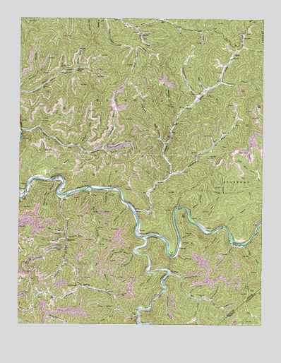
Majestic, KY USGS Topographic Map
Click on map above to begin viewing in our Map Viewer.

This topographic map contains these locations and features:
Feature Name Type Latitude Longitude GNIS ID View Map
Andy Trent BranchStreamN37.5329°W82.0096°485954View Map
Baker HollowValleyN37.5071°W82.0192°486250View Map
Bear BranchStreamN37.5351°W82.1001°486527View Map
Bear CreekStreamN37.5954°W82.0296°1535354View Map
Beech Ben Mate DistrictCivilN37.6052°W82.0227°2071872View Map
Beech CreekStreamN37.5459°W82.0654°1535519View Map
Beech Creek School (historical)SchoolN37.5821°W82.0451°1535520View Map
Beech Creek Volunteer Fire DepartmentBuildingN37.5936°W82.0324°2577714View Map
Big BranchStreamN37.5559°W82.0885°487110View Map
Bull BranchStreamN37.5390°W82.0232°488344View Map
CedarPopulated PlaceN37.5551°W82.1037°1554089View Map
Chapman ForkStreamN37.5257°W82.1010°489356View Map
Conley ForkStreamN37.5721°W82.0832°1537575View Map
Corner BranchStreamN37.5293°W82.0437°490120View Map
Cow BranchStreamN37.5379°W82.1012°490175View Map
Daniels BranchStreamN37.5551°W82.0799°490568View Map
DevonPopulated PlaceN37.5373°W82.0626°1549654View Map
Foundation ForkStreamN37.5926°W82.0326°1539172View Map
George BranchStreamN37.5337°W82.0421°492778View Map
Gibson HollowValleyN37.5202°W82.0017°492813View Map
Grant BranchStreamN37.5421°W82.0340°1539589View Map
Grapevine CreekStreamN37.5787°W82.1249°1539600View Map
Grapevine ForkStreamN37.5740°W82.0496°1539602View Map
HinchPopulated PlaceN37.6109°W82.0146°1540309View Map
Hurley SchoolSchoolN37.5043°W82.0640°494800View Map
Hurricane CreekStreamN37.5007°W82.0632°494830View Map
Hurricane HollowValleyN37.5357°W82.1000°494838View Map
Italy Hollow CemeteryCemeteryN37.5735°W82.0983°2586373View Map
Johnson ForkStreamN37.5196°W82.0410°495402View Map
Joiner BranchStreamN37.5218°W82.0568°495436View Map
Knox CreekStreamN37.5359°W82.0596°495859View Map
Lane ForkStreamN37.5146°W82.0065°495975View Map
Laurel BranchStreamN37.5407°W82.0182°1541364View Map
Left Fork Andy Trent BranchStreamN37.5254°W82.0015°496190View Map
Left Fork Andy Trent BranchStreamN37.5254°W82.0015°1469286View Map
Left Fork Malachi BranchStreamN37.5290°W82.0654°496239View Map
Lick BranchStreamN37.5954°W82.0293°1541836View Map
Lick BranchStreamN37.6198°W82.0318°1541838View Map
Lick ForkStreamN37.5062°W82.0743°496498View Map
Lick ForkStreamN37.5804°W82.1149°1541889View Map
Lick Fork Siding (historical)LocaleN37.5793°W82.1240°1728801View Map
LindseyPopulated PlaceN37.5393°W82.0293°1554956View Map
Little ForkStreamN37.5529°W82.0879°496733View Map
Lower Elk CreekStreamN37.5221°W82.0476°497276View Map
Lower Elk SchoolSchoolN37.5115°W82.0304°497277View Map
Lynntrough BranchStreamN37.5312°W82.1007°497384View Map
Magnolia DistrictCivilN37.6244°W82.1101°1928308View Map
MajesticPopulated PlaceN37.5340°W82.0999°497460View Map
Majestic Post OfficePost OfficeN37.5346°W82.1001°2336898View Map
Malachi BranchStreamN37.5134°W82.0782°497464View Map
MeadorPopulated PlaceN37.6190°W82.0623°1555093View Map
Meador ForkStreamN37.6215°W82.0643°1543048View Map
Middle BranchStreamN37.5465°W82.0376°1543157View Map
Mill HollowValleyN37.5352°W82.0414°498285View Map
Millseat BranchStreamN37.5723°W82.0832°1543415View Map
Mouth of Popular School (historical)SchoolN37.5523°W82.1018°2336934View Map
Mudlick ForkStreamN37.5848°W82.0435°1543945View Map
Murphy SchoolSchoolN37.5315°W82.0423°499117View Map
New Thacker (historical)Populated PlaceN37.5709°W82.0896°1728822View Map
North HollowValleyN37.5124°W82.0368°499575View Map
Persimmon BranchStreamN37.5146°W82.0493°500439View Map
Phelps Volunteer Fire Department Station 3BuildingN37.5062°W82.0736°2637416View Map
Poplar CreekStreamN37.5526°W82.1026°501095View Map
Pounding Mill BranchValleyN37.5373°W82.0001°1472724View Map
Pounding Mill BranchStreamN37.5387°W82.0029°501221View Map
Prater CreekStreamN37.6051°W82.0954°1545228View Map
Right Fork Lower Elk CreekStreamN37.5109°W82.0318°501905View Map
Right Fork Malachi BranchStreamN37.5296°W82.0640°501906View Map
Righthand Fork Beech CreekStreamN37.5629°W82.0468°1545735View Map
Righthand Fork School (historical)SchoolN37.5623°W82.0465°1728849View Map
Road ForkStreamN37.6129°W82.0657°1545801View Map
Sand BranchStreamN37.5596°W82.1087°1546338View Map
Scarberry BranchStreamN37.5559°W82.0790°1546481View Map
Shallow Shoal BranchStreamN37.5593°W82.1071°503235View Map
Shannon BranchStreamN37.5487°W82.0687°503240View Map
Simkins Family CemeteryCemeteryN37.5819°W82.0140°2586375View Map
Simpkins BranchStreamN37.5993°W82.0223°1728858View Map
Simpkins School (historical)SchoolN37.5759°W82.0223°1728859View Map
Slickrock BranchStreamN37.5334°W82.0143°503686View Map
Steele CemeteryCemeteryN37.5943°W82.0329°1547365View Map
StopoverPopulated PlaceN37.5159°W82.0912°509142View Map
Straight ForkStreamN37.6246°W82.0746°1547567View Map
Sumpkins BranchStreamN37.5993°W82.0221°1547743View Map
Swamp ForkStreamN37.5351°W82.0829°504829View Map
Thacker MinesPopulated PlaceN37.6037°W82.0968°1555797View Map
Thacker School (historical)SchoolN37.5968°W82.1135°1547994View Map
Turkey CreekStreamN37.5046°W82.0621°505589View Map
Turkey Fork SchoolSchoolN37.5159°W82.0940°505607View Map
Webb ForkStreamN37.6029°W82.1024°1548867View Map
Wolfpen ForkStreamN37.5729°W82.0957°1549326View Map
WoodmanPopulated PlaceN37.5212°W82.0446°509401View Map
Workman HollowValleyN37.5104°W82.0260°507148View Map
Yates ForkStreamN37.5065°W82.0726°507199View Map

Note: Coordinates in the location and feature list above are referenced to NAD83 datum.


Copyright (C) 2008-2024 Ryan Niemi / Sunset Dynamics ... All Rights Reserved