TopoQuest Logo
Do you find TopoQuest useful?
Help keep TopoQuest running and adding new maps/features by donating!
Bitcoin:  19c7KJd3qBynnjoSw5npx9KScwjBe4ifkT
Litecoin:  LXs6TkuXGGXo1vDsWCkWVdjQX94eUKd6ui
Home View Maps Find Maps Find Places Resources & Links


Mascoutah, Illinois Topographic Map

USGS Map Title: Mascoutah, IL
USGS Map MRC: 38089D7
DRG (GeoTIFF) Download: o38089d7.tif


Neighboring USGS Topographic Map Quads:


  O'Fallon, IL  
38089E8
 

  Lebanon, IL  
38089E7
 

  Trenton, IL  
38089E6
 

  Freeburg, IL  
38089D8
 

  Mascoutah, IL  
38089D7
 

  Venedy, IL  
38089D6
 

  New Athens West, IL  
38089C8
 

  New Athens East, IL  
38089C7
 

  Saint Libory, IL  
38089C6


Map MRC Location:

N39°
W90°
N39°
W89°
H8 H7 H6 H5 H4 H3 H2 H1
G8 G7 G6 G5 G4 G3 G2 G1
F8 F7 F6 F5 F4 F3 F2 F1
E8 E7 E6 E5 E4 E3 E2 E1
D8 D7 D6 D5 D4 D3 D2 D1
C8 C7 C6 C5 C4 C3 C2 C1
B8 B7 B6 B5 B4 B3 B2 B1
A8 A7 A6 A5 A4 A3 A2 A1
N38°
W90°
N38°
W89°

Mascoutah, IL USGS 1:24K Topographic Map Preview:
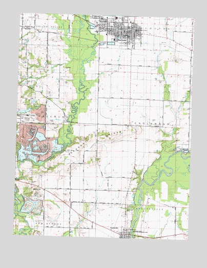
Mascoutah, IL USGS Topographic Map
Click on map above to begin viewing in our Map Viewer.

This topographic map contains these locations and features:
Feature Name Type Latitude Longitude GNIS ID View Map
American Legion Freedom ParkParkN38.4495°W89.8645°426017View Map
Andress CemeteryCemeteryN38.4420°W89.7776°426045View Map
Barth CemeteryCemeteryN38.4639°W89.7751°426047View Map
Batdorf School (historical)SchoolN38.4384°W89.8729°1821796View Map
Bethel United Methodist ChurchChurchN38.4906°W89.8004°426013View Map
Blum CemeteryCemeteryN38.4856°W89.7695°426275View Map
Bopp CemeteryCemeteryN38.4648°W89.7759°426046View Map
Bottom Lake (historical)LakeN38.4073°W89.7679°1773012View Map
Bowman PondLakeN38.4251°W89.8515°1821798View Map
Culli CemeteryCemeteryN38.4231°W89.8398°426038View Map
Dressler CemeteryCemeteryN38.3989°W89.8376°426039View Map
Drum Hill School (historical)SchoolN38.3859°W89.8254°1773015View Map
Engelmann School (historical)SchoolN38.4389°W89.7954°1773016View Map
Espenschied ChapelChurchN38.4992°W89.8179°426335View Map
FayettevillePopulated PlaceN38.3775°W89.7954°426340View Map
Fayetteville Community ParkParkN38.3787°W89.7995°426044View Map
Fayetteville Volunteer Fire DepartmentBuildingN38.3775°W89.7945°2640645View Map
First Assembly ChurchChurchN38.4906°W89.8023°426015View Map
Freedom Farm LakeReservoirN38.4506°W89.8630°1691402View Map
Freedom Farm Lake DamDamN38.4500°W89.8618°1691401View Map
Fries CemeteryCemeteryN38.4617°W89.8412°426032View Map
Fries CemeteryCemeteryN38.4856°W89.8515°426346View Map
Funk CemeteryCemeteryN38.4500°W89.8395°426036View Map
Funk CemeteryCemeteryN38.4398°W89.8401°426037View Map
Funk School (historical)SchoolN38.4528°W89.8545°1821823View Map
Geier CemeteryCemeteryN38.3764°W89.8570°426041View Map
Halfmoon LakeLakeN38.3782°W89.8694°426357View Map
Haubers HillSummitN38.4006°W89.8629°426361View Map
Hazel CreekStreamN38.4750°W89.8357°426362View Map
Heberers BranchStreamN38.4267°W89.8407°426363View Map
Hog RiverStreamN38.4562°W89.8273°426372View Map
Holy Childhood of Jesus Catholic ChurchChurchN38.4912°W89.7918°426020View Map
Holy Childhood of Jesus Catholic SchoolSchoolN38.4925°W89.7915°426019View Map
Holy Childhood of Jesus CemeteryCemeteryN38.4995°W89.8220°426375View Map
Jacks RunStreamN38.4131°W89.8737°426384View Map
Jackson SloughStreamN38.4078°W89.7751°426386View Map
Jefferson School (historical)SchoolN38.4092°W89.8032°1821854View Map
John Mueller CemeteryCemeteryN38.4523°W89.8682°426033View Map
Knobeloch CemeteryCemeteryN38.4978°W89.8637°426398View Map
Koch PondLakeN38.3926°W89.8699°1821856View Map
Leu Civil CenterParkN38.4925°W89.7968°426014View Map
Lincoln Lake CemeteryCemeteryN38.4884°W89.8037°426024View Map
Long LakeLakeN38.3983°W89.7885°426415View Map
Loop CreekStreamN38.4737°W89.8282°426416View Map
Maple ParkParkN38.4884°W89.7984°426025View Map
MascoutahPopulated PlaceN38.4903°W89.7932°426424View Map
Mascoutah Church of ChristChurchN38.4820°W89.7934°426021View Map
Mascoutah City CemeteryCemeteryN38.4992°W89.8209°426088View Map
Mascoutah City HallBuildingN38.4906°W89.7976°1821868View Map
Mascoutah Community High SchoolSchoolN38.4948°W89.8193°426028View Map
Mascoutah Department of Public Safety EMSBuildingN38.4907°W89.7977°2673901View Map
Mascoutah Fire DepartmentBuildingN38.4926°W89.7972°2640640View Map
Mascoutah Junior High SchoolSchoolN38.4995°W89.8062°426027View Map
Mascoutah Police DepartmentBuildingN38.4906°W89.7977°2758856View Map
Mascoutah Post OfficePost OfficeN38.4901°W89.7983°1821869View Map
Mascoutah SchoolSchoolN38.4953°W89.8084°426026View Map
Mason CemeteryCemeteryN38.4192°W89.8173°426029View Map
Mueller CemeteryCemeteryN38.4359°W89.8484°426440View Map
Mueller CemeteryCemeteryN38.4398°W89.8493°426035View Map
Peabody-River King Number 1 Mine HeliportAirportN38.4434°W89.8682°427297View Map
Pleasant RidgeRidgeN38.4287°W89.8243°426467View Map
Pleasant Ridge School (historical)SchoolN38.4087°W89.8357°1821879View Map
Rayhill SloughStreamN38.4453°W89.7615°426479View Map
Reinhardt SloughStreamN38.4453°W89.7615°426480View Map
RentchlerPopulated PlaceN38.4914°W89.8732°426482View Map
Rentchler Census Designated PlaceCensusN38.4919°W89.8690°2583442View Map
River King Mine LakeReservoirN38.4449°W89.8698°1691390View Map
River King Mine Number OneMineN38.4412°W89.8720°426018View Map
Ross CemeteryCemeteryN38.4487°W89.8704°1821885View Map
Roth CemeteryCemeteryN38.4323°W89.8179°426030View Map
Roth CemeteryCemeteryN38.4562°W89.8537°426034View Map
Round LakeLakeN38.3952°W89.7886°426492View Map
Saint Agatha CemeteryCemeteryN38.4050°W89.8637°426040View Map
Saint John United Church of ChristChurchN38.4912°W89.8004°426016View Map
Saint Pancratius CemeteryCemeteryN38.3909°W89.7948°426515View Map
Saint Pancratius ChurchChurchN38.3798°W89.7948°426042View Map
Scheve ParkParkN38.4970°W89.8095°1821889View Map
Schneblin CemeteryCemeteryN38.4984°W89.8168°426523View Map
Schubkegel CemeteryCemeteryN38.4700°W89.8415°426031View Map
Sheley CemeteryCemeteryN38.4759°W89.7618°426089View Map
Township of EngelmannCivilN38.4449°W89.7654°428972View Map
Township of FreeburgCivilN38.4382°W89.8717°429027View Map
Trinity ChurchChurchN38.3759°W89.7968°426043View Map
Village of FayettevilleCivilN38.3779°W89.7967°2398869View Map
Woodland GrangeBuildingN38.4392°W89.7951°428381View Map
Zion Lutheran ChurchChurchN38.4892°W89.7973°426022View Map
Zion Lutheran SchoolSchoolN38.4892°W89.7982°426023View Map

Note: Coordinates in the location and feature list above are referenced to NAD83 datum.


Copyright (C) 2008-2024 Ryan Niemi / Sunset Dynamics ... All Rights Reserved