TopoQuest Logo
Do you find TopoQuest useful?
Help keep TopoQuest running and adding new maps/features by donating!
Bitcoin:  19c7KJd3qBynnjoSw5npx9KScwjBe4ifkT
Litecoin:  LXs6TkuXGGXo1vDsWCkWVdjQX94eUKd6ui
Home View Maps Find Maps Find Places Resources & Links


McMillan Mountains, Texas Topographic Map

USGS Map Title: McMillan Mountains, TX
USGS Map MRC: 31097A7
DRG (GeoTIFF) Download: o31097a7.tif


Neighboring USGS Topographic Map Quads:


  Twin Mountains, TX  
31097B8
 

  Fort Hood, TX  
31097B7
 

  Post Oak Mountain, TX  
31097B6
 

  Copperas Cove, TX  
31097A8
 

  McMillan Mountains, TX  
31097A7
 

  Killeen, TX  
31097A6
 

  Briggs, TX  
30097H8
 

  Ding Dong, TX  
30097H7
 

  Youngsport, TX  
30097H6


Map MRC Location:

N32°
W98°
N32°
W97°
H8 H7 H6 H5 H4 H3 H2 H1
G8 G7 G6 G5 G4 G3 G2 G1
F8 F7 F6 F5 F4 F3 F2 F1
E8 E7 E6 E5 E4 E3 E2 E1
D8 D7 D6 D5 D4 D3 D2 D1
C8 C7 C6 C5 C4 C3 C2 C1
B8 B7 B6 B5 B4 B3 B2 B1
A8 A7 A6 A5 A4 A3 A2 A1
N31°
W98°
N31°
W97°

McMillan Mountains, TX USGS 1:24K Topographic Map Preview:
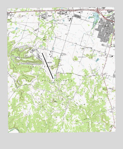
McMillan Mountains, TX USGS Topographic Map
Click on map above to begin viewing in our Map Viewer.

This topographic map contains these locations and features:
Feature Name Type Latitude Longitude GNIS ID View Map
American Educational ComplexSchoolN31.1199°W97.8095°1385356View Map
Bald KnobSummitN31.0430°W97.7620°1351452View Map
Blue Watch LakeReservoirN31.1046°W97.8648°1863349View Map
Blue Watch Lake DamDamN31.1052°W97.8636°1863348View Map
Browns CemeteryCemeteryN31.0599°W97.8184°1352995View Map
Calvary ChurchChurchN31.0049°W97.7547°1353578View Map
Camp MoonrakerLocaleN31.0371°W97.8092°1353653View Map
Cedar Crest Alternative SchoolSchoolN31.1135°W97.8000°2002884View Map
Central Texas State Veterans CemeteryCemeteryN31.0262°W97.7592°2773413View Map
Clear Creek Elementary SchoolSchoolN31.1166°W97.7897°2002887View Map
Clear Creek ParkParkN31.1193°W97.8253°1385357View Map
Copperas Cove Saddle ClubLocaleN31.1213°W97.8697°1385358View Map
Crossville MountainSummitN31.0932°W97.8300°1355417View Map
Ellison Ninth Grade CenterSchoolN31.0824°W97.7745°2002892View Map
Finlayson Youth CampLocaleN31.0991°W97.8350°1385359View Map
Fowler Elementary SchoolSchoolN31.0734°W97.8069°2002895View Map
Gray LakeReservoirN31.0554°W97.8207°1385360View Map
Henderson CemeteryCemeteryN31.1121°W97.8292°1385361View Map
Ivy GapGapN31.0471°W97.8622°1360054View Map
Ivy MountainSummitN31.0355°W97.8592°1360055View Map
Kay Bee HeightsPopulated PlaceN31.1185°W97.8314°1360503View Map
Killeen Air Force Station (historical)MilitaryN31.0517°W97.8633°2087770View Map
Killeen Fire Department Station 7BuildingN31.1082°W97.7696°2552365View Map
KLFX-FM (Harker Heights)TowerN31.0980°W97.7536°1387984View Map
Lake BratcherReservoirN31.0507°W97.8223°1352838View Map
Manere MountainSummitN31.0313°W97.8225°1362129View Map
Mayberry CemeteryCemeteryN31.0368°W97.8081°1362317View Map
McMillan MountainsSummitN31.0732°W97.7970°1362511View Map
Metroplex Behavioral Health CenterBuildingN31.1118°W97.8030°2718954View Map
Metroplex HospitalHospitalN31.1136°W97.8016°1385362View Map
Montague LakeReservoirN31.1134°W97.8214°1385363View Map
Montague Lake DamDamN31.1152°W97.8203°1863350View Map
Montague VillagePopulated PlaceN31.1166°W97.8328°2034581View Map
Mountain View EstatesPopulated PlaceN31.0052°W97.7628°1385364View Map
Mussie LakeReservoirN31.0549°W97.8317°1363521View Map
North Reese CreekStreamN31.0185°W97.7842°1364121View Map
Pathways Academic CampusSchoolN31.0534°W97.7516°2002915View Map
Pershing Park Elementary SchoolSchoolN31.1102°W97.7525°2002917View Map
Rattlesnake HillSummitN31.1160°W97.8614°1366042View Map
Reeces Creek Elementary SchoolSchoolN31.0766°W97.7522°2002863View Map
Robert Gray Army AirfieldAirportN31.0636°W97.8304°1386649View Map
Sevenmile MountainSummitN31.0743°W97.8711°1376072View Map
Sibley CemeteryCemeteryN31.0649°W97.8464°1385365View Map
Soil Conservation Service Site 1 DamDamN31.1168°W97.7670°1858882View Map
Soil Conservation Service Site 1 ReservoirReservoirN31.1168°W97.7670°1858883View Map
Sugar Loaf Elementary SchoolSchoolN31.0982°W97.7589°2002821View Map
Westside Baptist ChurchChurchN31.0560°W97.7559°2016428View Map
Willow Springs Community CenterLocaleN31.0974°W97.7800°1371674View Map
Willow Springs Elementary SchoolSchoolN31.0807°W97.7684°2002829View Map

Note: Coordinates in the location and feature list above are referenced to NAD83 datum.


Copyright (C) 2008-2024 Ryan Niemi / Sunset Dynamics ... All Rights Reserved