TopoQuest Logo
Do you find TopoQuest useful?
Help keep TopoQuest running and adding new maps/features by donating!
Bitcoin:  19c7KJd3qBynnjoSw5npx9KScwjBe4ifkT
Litecoin:  LXs6TkuXGGXo1vDsWCkWVdjQX94eUKd6ui
Home View Maps Find Maps Find Places Resources & Links


McRae, Arkansas Topographic Map

USGS Map Title: McRae, AR
USGS Map MRC: 35091A7
DRG (GeoTIFF) Download: o35091a7.tif


Neighboring USGS Topographic Map Quads:


  Floyd, AR  
35091B8
 

  Garner, AR  
35091B7
 

  Kensett, AR  
35091B6
 

  Beebe, AR  
35091A8
 

  McRae, AR  
35091A7
 

  Walker, AR  
35091A6
 

  Oak Grove, AR  
34091H8
 

  Wattensaw, AR  
34091H7
 

  Hickory Plains, AR  
34091H6


Map MRC Location:

N36°
W92°
N36°
W91°
H8 H7 H6 H5 H4 H3 H2 H1
G8 G7 G6 G5 G4 G3 G2 G1
F8 F7 F6 F5 F4 F3 F2 F1
E8 E7 E6 E5 E4 E3 E2 E1
D8 D7 D6 D5 D4 D3 D2 D1
C8 C7 C6 C5 C4 C3 C2 C1
B8 B7 B6 B5 B4 B3 B2 B1
A8 A7 A6 A5 A4 A3 A2 A1
N35°
W92°
N35°
W91°

McRae, AR USGS 1:24K Topographic Map Preview:
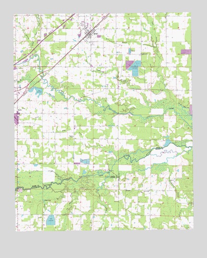
McRae, AR USGS Topographic Map
Click on map above to begin viewing in our Map Viewer.

This topographic map contains these locations and features:
Feature Name Type Latitude Longitude GNIS ID View Map
Bass CemeteryCemeteryN35.0170°W91.8387°46135View Map
Bland School (historical)SchoolN35.0029°W91.8613°61229View Map
Brush CreekStreamN35.0254°W91.8501°47042View Map
Bryles CemeteryCemeteryN35.0167°W91.8024°49747View Map
Cheek CemeteryCemeteryN35.0773°W91.7612°47718View Map
City of McRaeCivilN35.1117°W91.8258°2405055View Map
Cobb LakeLakeN35.0781°W91.8490°75676View Map
Cypress LakeLakeN35.0329°W91.8124°75690View Map
David ChapelChurchN35.0229°W91.7807°48367View Map
Dry BranchStreamN35.1051°W91.7746°48630View Map
Duck CreekStreamN35.0190°W91.8165°48677View Map
EdwardsPopulated PlaceN35.0234°W91.7974°57000View Map
Green CemeteryCemeteryN35.0092°W91.8374°49627View Map
Guess BranchStreamN35.0051°W91.8132°59090View Map
Gum CreekStreamN35.0893°W91.8685°49710View Map
Harrison ChapelChurchN35.0545°W91.8335°49911View Map
Hickory Plains CreekStreamN35.0473°W91.7510°50072View Map
Kinley LakeReservoirN35.0806°W91.8574°79765View Map
Kinley Lake DamDamN35.0818°W91.8585°79764View Map
Lawrence BranchStreamN35.0737°W91.7632°51004View Map
Lebanon ChurchChurchN35.1015°W91.7854°51033View Map
Little Cane CreekStreamN35.1015°W91.8590°51213View Map
Long CreekStreamN35.0401°W91.8032°51422View Map
McRaePopulated PlaceN35.1129°W91.8224°51882View Map
McRae Elementary SchoolSchoolN35.1170°W91.8247°65098View Map
McRae High SchoolSchoolN35.1167°W91.8238°65099View Map
Mcrae High SchoolSchoolN35.1168°W91.8240°2039131View Map
McRae Police DepartmentBuildingN35.1127°W91.8213°2118615View Map
McRae Post OfficePost OfficeN35.1132°W91.8214°84961View Map
McRae Volunteer Fire StationBuildingN35.1127°W91.8221°2116785View Map
McRae Volunteer Fire Station 2BuildingN35.1146°W91.8216°2116786View Map
Mill BranchStreamN35.1068°W91.8624°51980View Map
Pigeon Roost CreekStreamN35.0340°W91.8085°53365View Map
Red Cut SloughStreamN35.0293°W91.8413°53942View Map
Township of GarnerCivilN35.1195°W91.7563°69831View Map
Township of McRaeCivilN35.1011°W91.8139°69845View Map
White LakeLakeN35.0175°W91.8551°75885View Map
Young SubdivisionPopulated PlaceN35.0209°W91.8688°75259View Map

Note: Coordinates in the location and feature list above are referenced to NAD83 datum.


Copyright (C) 2008-2024 Ryan Niemi / Sunset Dynamics ... All Rights Reserved