TopoQuest Logo
Do you find TopoQuest useful?
Help keep TopoQuest running and adding new maps/features by donating!
Bitcoin:  19c7KJd3qBynnjoSw5npx9KScwjBe4ifkT
Litecoin:  LXs6TkuXGGXo1vDsWCkWVdjQX94eUKd6ui
Home View Maps Find Maps Find Places Resources & Links


Beebe, Arkansas Topographic Map

USGS Map Title: Beebe, AR
USGS Map MRC: 35091A8
DRG (GeoTIFF) Download: o35091a8.tif


Neighboring USGS Topographic Map Quads:


  Mount Vernon, AR  
35092B1
 

  Floyd, AR  
35091B8
 

  Garner, AR  
35091B7
 

  Mountain Springs, AR  
35092A1
 

  Beebe, AR  
35091A8
 

  McRae, AR  
35091A7
 

  Cabot, AR  
34092H1
 

  Oak Grove, AR  
34091H8
 

  Wattensaw, AR  
34091H7


Map MRC Location:

N36°
W92°
N36°
W91°
H8 H7 H6 H5 H4 H3 H2 H1
G8 G7 G6 G5 G4 G3 G2 G1
F8 F7 F6 F5 F4 F3 F2 F1
E8 E7 E6 E5 E4 E3 E2 E1
D8 D7 D6 D5 D4 D3 D2 D1
C8 C7 C6 C5 C4 C3 C2 C1
B8 B7 B6 B5 B4 B3 B2 B1
A8 A7 A6 A5 A4 A3 A2 A1
N35°
W92°
N35°
W91°

Beebe, AR USGS 1:24K Topographic Map Preview:
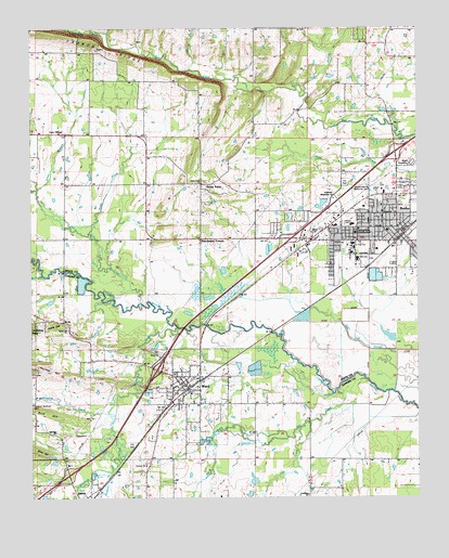
Beebe, AR USGS Topographic Map
Click on map above to begin viewing in our Map Viewer.

This topographic map contains these locations and features:
Feature Name Type Latitude Longitude GNIS ID View Map
Allied Ambulance ServiceBuildingN35.0289°W91.9490°2119092View Map
Apple HillSummitN35.0456°W91.9918°57275View Map
Apple Hill CemeteryCemeteryN35.0454°W91.9893°61226View Map
Apple Hill ChurchChurchN35.0448°W91.9882°45906View Map
Arkansas State Junior CollegeSchoolN35.0706°W91.8951°45925View Map
Arkansas State University Police Department BeebeBuildingN35.0707°W91.8951°2118613View Map
Baptist Student UnionChurchN35.0698°W91.8943°65034View Map
Barrentine CornerPopulated PlaceN35.0690°W91.9451°56918View Map
BeebePopulated PlaceN35.0706°W91.8796°81843View Map
Beebe City ParkParkN35.0834°W91.8974°65038View Map
Beebe Elementary SchoolSchoolN35.0657°W91.8965°65039View Map
Beebe Fire Department Main StationBuildingN35.0716°W91.8853°2116124View Map
Beebe High SchoolSchoolN35.0644°W91.8928°65040View Map
Beebe Intermediate SchoolSchoolN35.0652°W91.8947°2039122View Map
Beebe Junior High SchoolSchoolN35.0638°W91.8945°65041View Map
Beebe Middle SchoolSchoolN35.0654°W91.8934°2039120View Map
Beebe Police DepartmentBuildingN35.0700°W91.8815°2118612View Map
Beebe Primary SchoolSchoolN35.0649°W91.8966°2039121View Map
Beebe Shopping CenterLocaleN35.0745°W91.9015°65042View Map
Center Street Church of ChristChurchN35.0701°W91.8804°65047View Map
City of AustinCivilN35.0069°W91.9893°2403140View Map
City of BeebeCivilN35.0713°W91.9002°2403835View Map
City of WardCivilN35.0130°W91.9574°2405670View Map
Cocklebur ChurchChurchN35.0009°W91.9107°47879View Map
Country Road EstatesPopulated PlaceN35.0459°W91.9988°61225View Map
Essex (historical)Populated PlaceN35.1098°W91.9010°65062View Map
First Baptist ChurchChurchN35.0715°W91.8849°65063View Map
First Christian ChurchChurchN35.0679°W91.8799°65066View Map
First Church of the NazareneChurchN35.0726°W91.8807°65067View Map
First United Methodist ChurchChurchN35.0720°W91.8815°65068View Map
Fourmile CreekStreamN35.0454°W91.9526°76967View Map
Hudson BranchStreamN35.0068°W91.9746°45748View Map
Immanuel Baptist ChurchChurchN35.0673°W91.8768°65083View Map
Jones BranchStreamN35.0820°W91.9979°50714View Map
Kettle CreekStreamN35.0706°W91.9813°50827View Map
Lick CreekStreamN35.0187°W91.9135°51145View Map
Magness CreekStreamN35.0226°W91.9743°51608View Map
Mash BranchStreamN35.1137°W91.9490°51725View Map
Mill CreekStreamN35.0287°W91.9013°52017View Map
Negro BranchStreamN35.1076°W91.9110°52596View Map
Northstar Emergency Medical Service Beebe StationBuildingN35.0809°W91.8925°2119128View Map
Opal Fire DepartmentBuildingN35.0975°W91.9981°2116905View Map
Rock HillSummitN35.0223°W91.9940°58506View Map
Rocky BranchStreamN35.0593°W91.9963°54128View Map
Rocky Hill School (historical)SchoolN35.0187°W91.9993°61224View Map
Sims BranchStreamN35.0529°W91.9738°54868View Map
Stoney Point United Methodist ChurchChurchN35.0837°W91.9449°65117View Map
Stony PointLocaleN35.0834°W91.9449°55251View Map
Township of ChrispCivilN35.1233°W91.8835°69819View Map
Township of UnionCivilN35.0667°W91.8862°69852View Map
Township of WardCivilN35.0266°W91.9510°68836View Map
Turkey BranchStreamN35.1237°W91.9751°55709View Map
Union Valley Baptist ChurchChurchN35.0976°W91.9899°78628View Map
WardPopulated PlaceN35.0304°W91.9504°56036View Map
Ward Central Elementary SchoolSchoolN35.0113°W91.9603°2039199View Map
Ward Elementary SchoolSchoolN35.0301°W91.9551°61227View Map
Ward Police DepartmentBuildingN35.0302°W91.9551°2118771View Map
Ward Post OfficePost OfficeN35.0332°W91.9541°2781903View Map
Ward Volunteer Fire Department Station 1BuildingN35.0297°W91.9504°2117270View Map
Ward Volunteer Fire Department Station 2BuildingN35.0147°W91.9608°2117271View Map
White Oak CreekStreamN35.0520°W91.9643°56281View Map

Note: Coordinates in the location and feature list above are referenced to NAD83 datum.


Copyright (C) 2008-2024 Ryan Niemi / Sunset Dynamics ... All Rights Reserved