TopoQuest Logo
Do you find TopoQuest useful?
Help keep TopoQuest running and adding new maps/features by donating!
Bitcoin:  19c7KJd3qBynnjoSw5npx9KScwjBe4ifkT
Litecoin:  LXs6TkuXGGXo1vDsWCkWVdjQX94eUKd6ui
Home View Maps Find Maps Find Places Resources & Links


Millers Tavern, Virginia Topographic Map

USGS Map Title: Millers Tavern, VA
USGS Map MRC: 37076G8
DRG (GeoTIFF) Download: o37076g8.tif


Neighboring USGS Topographic Map Quads:


  Cauthornville, VA  
37077H1
 

  Mount Landing, VA  
37076H8
 

  Tappahannock, VA  
37076H7
 

  Aylett, VA  
37077G1
 

  Millers Tavern, VA  
37076G8
 

  Dunnsville, VA  
37076G7
 

  King William, VA  
37077F1
 

  King And Queen Court House, VA  
37076F8
 

  Truhart, VA  
37076F7


Map MRC Location:

N38°
W77°
N38°
W76°
H8 H7 H6 H5 H4 H3 H2 H1
G8 G7 G6 G5 G4 G3 G2 G1
F8 F7 F6 F5 F4 F3 F2 F1
E8 E7 E6 E5 E4 E3 E2 E1
D8 D7 D6 D5 D4 D3 D2 D1
C8 C7 C6 C5 C4 C3 C2 C1
B8 B7 B6 B5 B4 B3 B2 B1
A8 A7 A6 A5 A4 A3 A2 A1
N37°
W77°
N37°
W76°

Millers Tavern, VA USGS 1:24K Topographic Map Preview:
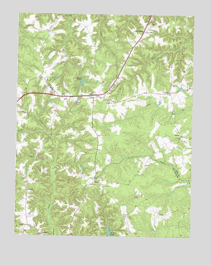
Millers Tavern, VA USGS Topographic Map
Click on map above to begin viewing in our Map Viewer.

This topographic map contains these locations and features:
Feature Name Type Latitude Longitude GNIS ID View Map
Aylett Country Day SchoolSchoolN37.8066°W76.9404°2465191View Map
BestlandPopulated PlaceN37.8074°W76.8825°1477113View Map
Bestland BridgeBridgeN37.7821°W76.8764°1739410View Map
Bethlehem ChurchChurchN37.7821°W76.9922°1463240View Map
Beulah ChurchChurchN37.8646°W76.9780°1463273View Map
Beulah School (historical)SchoolN37.8640°W76.9780°1739411View Map
BruingtonPopulated PlaceN37.7754°W76.9914°1495314View Map
Covington BridgeBridgeN37.8201°W76.8891°1739422View Map
CrouchPopulated PlaceN37.7624°W76.8972°1495445View Map
DaisyPopulated PlaceN37.7613°W76.9216°1477243View Map
Dickeys HillSummitN37.7510°W76.9797°1495468View Map
Dogwood ForkStreamN37.7896°W76.9725°1465878View Map
Faith Baptist ChurchChurchN37.8586°W76.9148°2520289View Map
Fleets CreekStreamN37.8079°W76.9789°1466688View Map
Grace Episcopal ChurchChurchN37.8264°W76.9344°2520342View Map
Grace Mission ChurchChurchN37.8265°W76.9341°1467326View Map
Henleys ForkPopulated PlaceN37.7557°W76.9905°1477406View Map
Howerton ChurchChurchN37.8354°W76.8886°1468336View Map
HowertonsPopulated PlaceN37.8312°W76.8900°1477427View Map
Ice House PondReservoirN37.7511°W76.9321°1502042View Map
John Moncure SchoolSchoolN37.8257°W76.9339°1468759View Map
Jones BridgeBridgeN37.7951°W76.9039°1739435View Map
Millers TavernPopulated PlaceN37.8282°W76.9450°1470571View Map
Millers Tavern Post OfficePost OfficeN37.8295°W76.9495°2766476View Map
MinorPopulated PlaceN37.8393°W76.9827°1477544View Map
Oak Grove ChurchChurchN37.8065°W76.8830°1471729View Map
Pauls CrossroadsPopulated PlaceN37.8651°W76.9102°1496064View Map
PowcanPopulated PlaceN37.7824°W76.9427°1477643View Map
PrinceLocaleN37.7901°W76.9077°1472792View Map
Providence ChurchChurchN37.7785°W76.9369°1472830View Map
Rock of Ages ChurchChurchN37.8654°W76.9086°1473381View Map
Saint Pauls ChurchChurchN37.8288°W76.9675°1473885View Map
Smyrna CemeteryCemeteryN37.7785°W76.9452°1739311View Map
Smyrna ChurchChurchN37.7790°W76.9452°1474793View Map
Tappahannock-Essex County AirportAirportN37.8610°W76.8991°2633446View Map
Trinity ChurchChurchN37.8396°W76.9286°1475877View Map
Wrights MillpondReservoirN37.8347°W76.9528°1502120View Map
Wrights Millpond DamDamN37.8390°W76.9533°1489649View Map

Note: Coordinates in the location and feature list above are referenced to NAD83 datum.


Copyright (C) 2008-2024 Ryan Niemi / Sunset Dynamics ... All Rights Reserved