TopoQuest Logo
Do you find TopoQuest useful?
Help keep TopoQuest running and adding new maps/features by donating!
Bitcoin:  19c7KJd3qBynnjoSw5npx9KScwjBe4ifkT
Litecoin:  LXs6TkuXGGXo1vDsWCkWVdjQX94eUKd6ui
Home View Maps Find Maps Find Places Resources & Links


Dunnsville, Virginia Topographic Map

USGS Map Title: Dunnsville, VA
USGS Map MRC: 37076G7
DRG (GeoTIFF) Download: o37076g7.tif


Neighboring USGS Topographic Map Quads:


  Mount Landing, VA  
37076H8
 

  Tappahannock, VA  
37076H7
 

  Haynesville, VA  
37076H6
 

  Millers Tavern, VA  
37076G8
 

  Dunnsville, VA  
37076G7
 

  Morattico, VA  
37076G6
 

  King And Queen Court House, VA  
37076F8
 

  Truhart, VA  
37076F7
 

  Church View, VA  
37076F6


Map MRC Location:

N38°
W77°
N38°
W76°
H8 H7 H6 H5 H4 H3 H2 H1
G8 G7 G6 G5 G4 G3 G2 G1
F8 F7 F6 F5 F4 F3 F2 F1
E8 E7 E6 E5 E4 E3 E2 E1
D8 D7 D6 D5 D4 D3 D2 D1
C8 C7 C6 C5 C4 C3 C2 C1
B8 B7 B6 B5 B4 B3 B2 B1
A8 A7 A6 A5 A4 A3 A2 A1
N37°
W77°
N37°
W76°

Dunnsville, VA USGS 1:24K Topographic Map Preview:
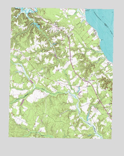
Dunnsville, VA USGS Topographic Map
Click on map above to begin viewing in our Map Viewer.

This topographic map contains these locations and features:
Feature Name Type Latitude Longitude GNIS ID View Map
Angel Visit ChurchChurchN37.8290°W76.8016°1462476View Map
Bellview CreekStreamN37.8690°W76.7836°1463055View Map
Bowlers WharfLocaleN37.8229°W76.7525°1463713View Map
Browns PointCapeN37.8454°W76.7650°1463930View Map
Byrds BridgeBridgeN37.7718°W76.7897°1739417View Map
Center CrossPopulated PlaceN37.8046°W76.7788°1464672View Map
Center Cross Church of GodChurchN37.8005°W76.7804°2520222View Map
Center Cross Post OfficePost OfficeN37.8050°W76.7785°2766445View Map
Center Cross School (historical)SchoolN37.8029°W76.7677°1739419View Map
ContraPopulated PlaceN37.7607°W76.8436°1477222View Map
Contrary SwampStreamN37.7901°W76.8541°1465181View Map
Dew DamDamN37.7851°W76.8580°1490181View Map
Dew PondReservoirN37.7841°W76.8589°1490182View Map
Dragon RunStreamN37.7979°W76.8419°1465940View Map
DunnsvillePopulated PlaceN37.8576°W76.8197°1492891View Map
Dunnsville Post OfficePost OfficeN37.8585°W76.8212°2519609View Map
Ephesus ChurchChurchN37.8557°W76.8116°1466329View Map
Essex Mill (historical)LocaleN37.8607°W76.8450°1739426View Map
Essex Mill DamDamN37.8590°W76.8427°1489640View Map
Essex MillpondReservoirN37.8581°W76.8437°1502011View Map
EubankPopulated PlaceN37.8521°W76.7727°1478000View Map
Good Hope ChurchChurchN37.8560°W76.8252°1467209View Map
Hundley DamDamN37.7968°W76.7897°1489646View Map
InoPopulated PlaceN37.7624°W76.7977°1477436View Map
Lebanon ChurchChurchN37.8129°W76.8389°1469249View Map
Macedonia ChurchChurchN37.7835°W76.7525°1469975View Map
Marry Gold PlantationLocaleN37.8174°W76.8164°1739444View Map
Merryvayle CreekStreamN37.8737°W76.8602°1739445View Map
Mill CreekStreamN37.8685°W76.8547°1470494View Map
Mill StreamStreamN37.7554°W76.8469°1470544View Map
Mill SwampStreamN37.8296°W76.7586°1470546View Map
Miller GreenhousesBuildingN37.7847°W76.7761°2677807View Map
Mouth BarBarN37.8668°W76.7533°1477999View Map
Muddy GutStreamN37.8340°W76.7616°1471231View Map
Mussel SwampStreamN37.8712°W76.8611°1471291View Map
North Branch Beaverdam SwampStreamN37.8740°W76.7933°1739450View Map
OakleyPopulated PlaceN37.7749°W76.7550°1477588View Map
OzeanaPopulated PlaceN37.8251°W76.8014°1493387View Map
Poplar SwampStreamN37.8282°W76.7597°1739453View Map
Rappahannock CemeteryCemeteryN37.8482°W76.8038°1472979View Map
Rappahannock ChurchChurchN37.8587°W76.8208°1472981View Map
Rappahannock District SchoolSchoolN37.8004°W76.7802°1472983View Map
Rappahannock Independent Academy (historical)SchoolN37.8404°W76.7975°1739455View Map
Rose Hill DamDamN37.7668°W76.7797°1489647View Map
Rose Hill PondReservoirN37.7716°W76.7790°1489648View Map
Saint Andrews Church (historical)ChurchN37.8060°W76.8247°1739457View Map
Saint Lukes Church (historical)ChurchN37.7701°W76.7505°1739458View Map
Smith and Rices Mill (historical)LocaleN37.8279°W76.8158°1739462View Map
South DistrictCivilN37.8191°W76.8020°1927505View Map
Stiffs Mill (historical)LocaleN37.8232°W76.7877°1739463View Map
Tappahannock - Essex Volunteer Fire Department Station 2BuildingN37.8079°W76.7888°2331784View Map
Trinity ChurchChurchN37.8054°W76.7808°1475876View Map
Tuscarora CreekStreamN37.8657°W76.7830°1475995View Map
Union Hope Baptist ChurchChurchN37.7835°W76.7525°2519859View Map
Union Hope ChurchChurchN37.7507°W76.7925°1476083View Map
UprightPopulated PlaceN37.8099°W76.8377°1477835View Map
Ware DamDamN37.8401°W76.8230°1489645View Map
Wares Mill (historical)LocaleN37.8404°W76.8236°1739472View Map
Wares WharfPopulated PlaceN37.8737°W76.7836°1493757View Map
Waterview Plantation (historical)LocaleN37.8668°W76.7872°1739473View Map
White MarshStreamN37.7896°W76.7936°1476591View Map
Wyatts DamDamN37.7535°W76.7747°1490177View Map
Yorkers SwampStreamN37.7651°W76.7791°1474357View Map

Note: Coordinates in the location and feature list above are referenced to NAD83 datum.


Copyright (C) 2008-2024 Ryan Niemi / Sunset Dynamics ... All Rights Reserved