TopoQuest Logo
Do you find TopoQuest useful?
Help keep TopoQuest running and adding new maps/features by donating!
Bitcoin:  19c7KJd3qBynnjoSw5npx9KScwjBe4ifkT
Litecoin:  LXs6TkuXGGXo1vDsWCkWVdjQX94eUKd6ui
Home View Maps Find Maps Find Places Resources & Links


Missouri Valley, Iowa Topographic Map

USGS Map Title: Missouri Valley, IA
USGS Map MRC: 41095E8
DRG (GeoTIFF) Download: o41095e8.tif


Neighboring USGS Topographic Map Quads:


  Mondamin, IA  
41096F1
 

  Missouri Valley NW, IA  
41095F8
 

  Logan, IA  
41095F7
 

  Modale, IA  
41096E1
 

  Missouri Valley, IA  
41095E8
 

  Beebeetown, IA  
41095E7
 

  Fort Calhoun, NE  
41096D1
 

  Loveland, IA  
41095D8
 

  Honey Creek, IA  
41095D7


Map MRC Location:

N42°
W96°
N42°
W95°
H8 H7 H6 H5 H4 H3 H2 H1
G8 G7 G6 G5 G4 G3 G2 G1
F8 F7 F6 F5 F4 F3 F2 F1
E8 E7 E6 E5 E4 E3 E2 E1
D8 D7 D6 D5 D4 D3 D2 D1
C8 C7 C6 C5 C4 C3 C2 C1
B8 B7 B6 B5 B4 B3 B2 B1
A8 A7 A6 A5 A4 A3 A2 A1
N41°
W96°
N41°
W95°

Missouri Valley, IA USGS 1:24K Topographic Map Preview:
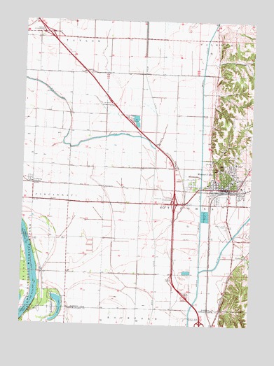
Missouri Valley, IA USGS Topographic Map
Click on map above to begin viewing in our Map Viewer.

This topographic map contains these locations and features:
Feature Name Type Latitude Longitude GNIS ID View Map
Alegent Health Missouri Valley CenterHospitalN41.5630°W95.8847°1982068View Map
California JunctionLocaleN41.5583°W95.9953°1981988View Map
California JunctionPopulated PlaceN41.5586°W95.9947°455054View Map
California Junction Census Designated PlaceCensusN41.5602°W95.9948°2583481View Map
California Post Office (historical)Post OfficeN41.5586°W95.9947°1981989View Map
Calvary Baptist ChurchChurchN41.5561°W95.8914°1982081View Map
CHI Health Missouri Valley HospitalHospitalN41.5627°W95.8857°1982069View Map
Christ Community FellowshipChurchN41.5572°W95.8947°1982072View Map
Church of ChristChurchN41.5572°W95.8936°1982074View Map
Church of the NazareneChurchN41.5650°W95.8870°1982079View Map
City of Missouri ValleyCivilN41.5574°W95.9028°2395356View Map
Euclid CreekStreamN41.5453°W95.8756°456400View Map
FindlayLocaleN41.5283°W95.8783°1981972View Map
FindleyPopulated PlaceN41.5286°W95.8792°456591View Map
First Baptist ChurchChurchN41.5569°W95.8892°1982077View Map
First Lutheran ChurchChurchN41.5639°W95.8847°1982080View Map
First Presbyterian ChurchChurchN41.5583°W95.8903°1982076View Map
Fish Lake Wildlife AreaParkN41.5778°W95.9358°1981964View Map
Harrison County FairgroundLocaleN41.5564°W95.9100°1982063View Map
Interchange 75CrossingN41.5500°W95.9172°1982149View Map
Interchange 82CrossingN41.6200°W95.9878°1982148View Map
Lone Tree Lake (historical)LakeN41.5361°W95.9920°465433View Map
Longview HomeHospitalN41.5667°W95.8839°1982071View Map
Midwest Urology CenterHospitalN41.5625°W95.8856°1982070View Map
Missouri ValleyPopulated PlaceN41.5564°W95.8878°459150View Map
Missouri ValleyLocaleN41.5555°W95.8920°1982066View Map
Missouri Valley AirportAirportN41.5403°W95.8878°466878View Map
Missouri Valley Congregational ChurchChurchN41.5608°W95.8800°1982082View Map
Missouri Valley Elementary and Early Learning CenterSchoolN41.5619°W95.8829°1982083View Map
Missouri Valley Fire DepartmentBuildingN41.5567°W95.8924°2371655View Map
Missouri Valley Grain Incorporated ElevatorLocaleN41.5528°W95.8939°1982061View Map
Missouri Valley High SchoolSchoolN41.5629°W95.8799°1982041View Map
Missouri Valley LibraryBuildingN41.5569°W95.8892°1982060View Map
Missouri Valley Middle SchoolSchoolN41.5627°W95.8798°1982040View Map
Missouri Valley North Bound Rest AreaLocaleN41.5833°W95.9414°1982146View Map
Missouri Valley Police DepartmentBuildingN41.5562°W95.8937°1982062View Map
Missouri Valley Post OfficePost OfficeN41.5569°W95.8886°1982059View Map
Missouri Valley South Bound Rest AreaLocaleN41.5922°W95.9536°1982145View Map
Mount Carmel CemeteryCemeteryN41.5675°W95.8900°459284View Map
Nobles LakeLakeN41.5071°W95.9788°459535View Map
Nobles Lake State Wildlife Management AreaParkN41.5067°W95.9814°459536View Map
Old Frazier CemeteryCemeteryN41.5722°W95.8892°1982139View Map
Olsen Airport (historical)AirportN41.6128°W95.8956°466879View Map
Rainbow Dental CenterHospitalN41.5558°W95.8897°1982067View Map
Reorganized Church of Jesus Christ of Latter Day SaintsChurchN41.5578°W95.8945°1982073View Map
Robinson Airport (historical)AirportN41.5319°W95.9420°466880View Map
Rose Hill CemeteryCemeteryN41.5658°W95.8914°460792View Map
Saint John Post Office (historical)Post OfficeN41.5278°W95.8781°1981995View Map
Saint Johns Wildlife AreaParkN41.5833°W95.9392°1981965View Map
Saint Patricks ChurchChurchN41.5578°W95.8870°1982078View Map
Saint Paul Lutheran ChurchChurchN41.5578°W95.8936°1982075View Map
Township of Saint JohnCivilN41.5548°W95.8895°468655View Map
United Western Co-op ElevatorLocaleN41.5569°W95.8825°1982058View Map
Willow CreekStreamN41.5225°W95.9028°463075View Map
Wilson DitchCanalN41.5264°W95.9511°463104View Map

Note: Coordinates in the location and feature list above are referenced to NAD83 datum.


Copyright (C) 2008-2024 Ryan Niemi / Sunset Dynamics ... All Rights Reserved