TopoQuest Logo
Do you find TopoQuest useful?
Help keep TopoQuest running and adding new maps/features by donating!
Bitcoin:  19c7KJd3qBynnjoSw5npx9KScwjBe4ifkT
Litecoin:  LXs6TkuXGGXo1vDsWCkWVdjQX94eUKd6ui
Home View Maps Find Maps Find Places Resources & Links


Mondamin, Iowa Topographic Map

USGS Map Title: Mondamin, IA
USGS Map MRC: 41096F1
DRG (GeoTIFF) Download: o41096f1.tif


Neighboring USGS Topographic Map Quads:


  Tekamah, NE  
41096G2
 

  Little Sioux, IA  
41096G1
 

  Pisgah, IA  
41095G8
 

  Herman, NE  
41096F2
 

  Mondamin, IA  
41096F1
 

  Missouri Valley NW, IA  
41095F8
 

  Blair, NE  
41096E2
 

  Modale, IA  
41096E1
 

  Missouri Valley, IA  
41095E8


Map MRC Location:

N42°
W97°
N42°
W96°
H8 H7 H6 H5 H4 H3 H2 H1
G8 G7 G6 G5 G4 G3 G2 G1
F8 F7 F6 F5 F4 F3 F2 F1
E8 E7 E6 E5 E4 E3 E2 E1
D8 D7 D6 D5 D4 D3 D2 D1
C8 C7 C6 C5 C4 C3 C2 C1
B8 B7 B6 B5 B4 B3 B2 B1
A8 A7 A6 A5 A4 A3 A2 A1
N41°
W97°
N41°
W96°

Mondamin, IA USGS 1:24K Topographic Map Preview:
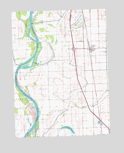
Mondamin, IA USGS Topographic Map
Click on map above to begin viewing in our Map Viewer.

This topographic map contains these locations and features:
Feature Name Type Latitude Longitude GNIS ID View Map
Bullard BluffBendN41.7103°W96.0947°835010View Map
Burcham DitchCanalN41.6872°W96.0358°454987View Map
Church of ChristChurchN41.7122°W96.0220°1982048View Map
City of MondaminCivilN41.7100°W96.0215°2395369View Map
Hauger CemeteryCemeteryN41.6389°W96.0503°1982136View Map
Holy Family Catholic ChurchChurchN41.7075°W96.0211°1982050View Map
Horseshoe LakeLakeN41.6337°W96.0572°464202View Map
Interchange 89CrossingN41.7111°W96.0447°1982147View Map
Missouri Dale Wildlife AreaParkN41.6319°W96.0017°1981962View Map
Modamin / Noyes CemeteryCemeteryN41.7189°W96.0328°459676View Map
MondaminLocaleN41.7111°W96.0239°1982051View Map
MondaminPopulated PlaceN41.7105°W96.0217°459168View Map
Mondamin Baptist ChurchChurchN41.7094°W96.0203°1982047View Map
Mondamin CemeteryCemeteryN41.7189°W96.0320°1982138View Map
Mondamin City HallBuildingN41.7100°W96.0236°1982042View Map
Mondamin Fire and Rescue AssociationBuildingN41.7103°W96.0144°1982043View Map
Mondamin Post OfficePost OfficeN41.7100°W96.0228°1982044View Map
Mondamin Public LibraryBuildingN41.7105°W96.0217°1982045View Map
Mondamin Wildlife AreaParkN41.7000°W96.0442°1981969View Map
Old Soldier River DitchCanalN41.6511°W96.0564°459837View Map
Remington Boat LaunchLocaleN41.6861°W96.1197°1981967View Map
Reorganized Church of Jesus Christ of Latter Day SaintsChurchN41.7080°W96.0217°1982049View Map
Round LakeReservoirN41.7333°W96.0328°460827View Map
Round Lake State Wildlife Management AreaParkN41.7386°W96.0375°460829View Map
Sandy Point BendBendN41.6600°W96.0981°464397View Map
Soldier Bend Wildlife AreaParkN41.6958°W96.1058°1981968View Map
Soldier RiverStreamN41.7375°W96.0978°461744View Map
Spooner DitchCanalN41.6967°W96.0017°461856View Map
Township of ClayCivilN41.6468°W96.0662°467605View Map
Township of MorganCivilN41.7254°W96.0483°468407View Map
United Western Co-op ElevatorLocaleN41.7108°W96.0236°1982046View Map
West Harrison Elementary schoolSchoolN41.7088°W96.0187°1982052View Map
West Harrison Middle / High SchoolSchoolN41.7088°W96.0174°2719820View Map
Yutsler CemeteryCemeteryN41.6684°W96.0372°1982137View Map

Note: Coordinates in the location and feature list above are referenced to NAD83 datum.


Copyright (C) 2008-2024 Ryan Niemi / Sunset Dynamics ... All Rights Reserved