TopoQuest Logo
Do you find TopoQuest useful?
Help keep TopoQuest running and adding new maps/features by donating!
Bitcoin:  19c7KJd3qBynnjoSw5npx9KScwjBe4ifkT
Litecoin:  LXs6TkuXGGXo1vDsWCkWVdjQX94eUKd6ui
Home View Maps Find Maps Find Places Resources & Links


Monterey, Kentucky Topographic Map

USGS Map Title: Monterey, KY
USGS Map MRC: 38084D7
DRG (GeoTIFF) Download: o38084d7.tif


Neighboring USGS Topographic Map Quads:


  New Liberty, KY  
38084E8
 

  Owenton, KY  
38084E7
 

  Lawrenceville, KY  
38084E6
 

  Gratz, KY  
38084D8
 

  Monterey, KY  
38084D7
 

  New Columbus, KY  
38084D6
 

  Polsgrove, KY  
38084C8
 

  Switzer, KY  
38084C7
 

  Stamping Ground, KY  
38084C6


Map MRC Location:

N39°
W85°
N39°
W84°
H8 H7 H6 H5 H4 H3 H2 H1
G8 G7 G6 G5 G4 G3 G2 G1
F8 F7 F6 F5 F4 F3 F2 F1
E8 E7 E6 E5 E4 E3 E2 E1
D8 D7 D6 D5 D4 D3 D2 D1
C8 C7 C6 C5 C4 C3 C2 C1
B8 B7 B6 B5 B4 B3 B2 B1
A8 A7 A6 A5 A4 A3 A2 A1
N38°
W85°
N38°
W84°

Monterey, KY USGS 1:24K Topographic Map Preview:
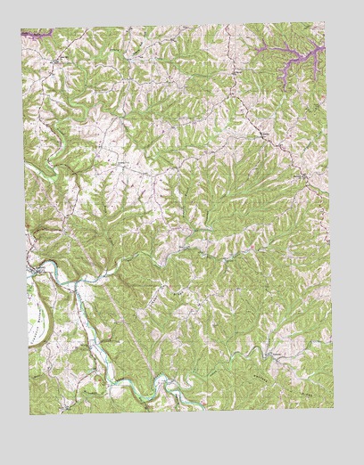
Monterey, KY USGS Topographic Map
Click on map above to begin viewing in our Map Viewer.

This topographic map contains these locations and features:
Feature Name Type Latitude Longitude GNIS ID View Map
Assembly of God (historical)ChurchN38.4626°W84.7801°2567470View Map
Bowen BranchStreamN38.4195°W84.8424°487730View Map
Cedar Hill (historical)Populated PlaceN38.4893°W84.8609°2742115View Map
Cedar Hill ChurchChurchN38.4898°W84.8597°489221View Map
Cedar Hill School (historical)SchoolN38.4898°W84.8609°2567483View Map
City of MontereyCivilN38.4233°W84.8728°2404286View Map
Claxon RidgeRidgeN38.4151°W84.8199°489564View Map
Claxton School (historical)SchoolN38.3974°W84.8074°2567484View Map
East Eagle Post Office (historical)Post OfficeN38.4498°W84.7578°2567363View Map
El Bethel Christian ChurchChurchN38.4842°W84.7888°491602View Map
El Bethel Christian Church CemeteryCemeteryN38.4839°W84.7886°1900877View Map
Elk Lick ChurchChurchN38.4234°W84.7933°491666View Map
Elk Lick CreekStreamN38.4290°W84.8091°491668View Map
Ep Post Office (historical)Post OfficeN38.4650°W84.8411°2567366View Map
Greenup CreekStreamN38.4737°W84.8480°493341View Map
Greenup Fork (historical)Populated PlaceN38.4533°W84.8306°2742116View Map
Greenup Fork Baptist Church CemeteryCemeteryN38.4553°W84.8377°1900894View Map
Greenup Fork ChurchChurchN38.4553°W84.8372°493342View Map
Greenup Fork Post Office (historical)Post OfficeN38.4524°W84.8258°2567373View Map
Greenup School (historical)SchoolN38.4526°W84.8259°2567374View Map
Haydons Post Office (historical)Post OfficeN38.4293°W84.7523°2567380View Map
Haydons Stand (historical)LocaleN38.4288°W84.7511°2567381View Map
HeslerPopulated PlaceN38.4637°W84.7772°494094View Map
Hesler Post Office (historical)Post OfficeN38.4641°W84.7769°2567383View Map
Honeysuckle HillSummitN38.4257°W84.8670°2567385View Map
Indian CreekStreamN38.3856°W84.8180°494923View Map
Kays BranchStreamN38.3803°W84.8288°495582View Map
McDowell BranchStreamN38.4331°W84.8055°497843View Map
MontereyPopulated PlaceN38.4220°W84.8724°498496View Map
Monterey Baptist ChurchChurchN38.4248°W84.8724°1900943View Map
Monterey Baptist Church CemeteryCemeteryN38.4248°W84.8724°1900942View Map
Monterey CemeteryCemeteryN38.4220°W84.8713°1900941View Map
Monterey Post Office (historical)Post OfficeN38.4218°W84.8716°2567407View Map
Monterey School (historical)SchoolN38.4313°W84.8713°2567408View Map
Monterey Volunteer Fire DepartmentBuildingN38.4152°W84.8555°2636504View Map
Monterey-New Columbus DivisionCivilN38.4311°W84.7514°1937150View Map
Morgadore CreekStreamN38.3848°W84.8405°498581View Map
NewPopulated PlaceN38.4278°W84.8105°508692View Map
Old Cedar ChurchChurchN38.3970°W84.8491°499810View Map
Paytons RidgeRidgeN38.3820°W84.7708°500303View Map
Perkins CemeteryCemeteryN38.4731°W84.7527°500415View Map
Plummer BranchStreamN38.3815°W84.8169°500978View Map
Richland Baptist ChurchChurchN38.4503°W84.7608°501817View Map
Richland Baptist Church (historical)ChurchN38.4516°W84.7552°2567429View Map
Richland Baptist Church CemeteryCemeteryN38.4498°W84.7608°1900968View Map
Sanders CemeteryCemeteryN38.4148°W84.8663°1900978View Map
Sawdridge CreekStreamN38.4176°W84.8544°503010View Map
School Number Eighty-One (historical)SchoolN38.4829°W84.8336°2567434View Map
School Number Ninety-Eight (historical)SchoolN38.4474°W84.7597°2567437View Map
Slippery Rock CreekStreamN38.4892°W84.8316°503696View Map
TeresitaPopulated PlaceN38.3928°W84.7761°509196View Map
Teresita Post Office (historical)Post OfficeN38.3926°W84.7764°2567456View Map
Walnut Grove Methodist Church (historical)ChurchN38.3933°W84.7764°2567462View Map
Webster CemeteryCemeteryN38.3767°W84.8602°506344View Map
Webster CemeteryCemeteryN38.4034°W84.7983°506345View Map
Wiley BranchStreamN38.3845°W84.7607°2567467View Map

Note: Coordinates in the location and feature list above are referenced to NAD83 datum.


Copyright (C) 2008-2024 Ryan Niemi / Sunset Dynamics ... All Rights Reserved