TopoQuest Logo
Do you find TopoQuest useful?
Help keep TopoQuest running and adding new maps/features by donating!
Bitcoin:  19c7KJd3qBynnjoSw5npx9KScwjBe4ifkT
Litecoin:  LXs6TkuXGGXo1vDsWCkWVdjQX94eUKd6ui
Home View Maps Find Maps Find Places Resources & Links


Owenton, Kentucky Topographic Map

USGS Map Title: Owenton, KY
USGS Map MRC: 38084E7
DRG (GeoTIFF) Download: o38084e7.tif


Neighboring USGS Topographic Map Quads:


  Sanders, KY  
38084F8
 

  Glencoe, KY  
38084F7
 

  Elliston, KY  
38084F6
 

  New Liberty, KY  
38084E8
 

  Owenton, KY  
38084E7
 

  Lawrenceville, KY  
38084E6
 

  Gratz, KY  
38084D8
 

  Monterey, KY  
38084D7
 

  New Columbus, KY  
38084D6


Map MRC Location:

N39°
W85°
N39°
W84°
H8 H7 H6 H5 H4 H3 H2 H1
G8 G7 G6 G5 G4 G3 G2 G1
F8 F7 F6 F5 F4 F3 F2 F1
E8 E7 E6 E5 E4 E3 E2 E1
D8 D7 D6 D5 D4 D3 D2 D1
C8 C7 C6 C5 C4 C3 C2 C1
B8 B7 B6 B5 B4 B3 B2 B1
A8 A7 A6 A5 A4 A3 A2 A1
N38°
W85°
N38°
W84°

Owenton, KY USGS 1:24K Topographic Map Preview:
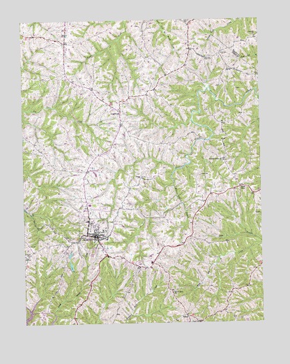
Owenton, KY USGS Topographic Map
Click on map above to begin viewing in our Map Viewer.

This topographic map contains these locations and features:
Feature Name Type Latitude Longitude GNIS ID View Map
Beech Grove Baptist ChurchChurchN38.5131°W84.7969°486729View Map
Beech Grove Baptist Church CemeteryCemeteryN38.5128°W84.7966°1900840View Map
City of OwentonCivilN38.5385°W84.8409°2404449View Map
Concord ChurchChurchN38.6176°W84.7522°489938View Map
Doty CemeteryCemeteryN38.5326°W84.8722°491035View Map
Duvall and Steger CemeteryCemeteryN38.6089°W84.7788°491371View Map
Elk RidgeRidgeN38.5138°W84.7630°2567364View Map
Elk Ridge Post Office (historical)Post OfficeN38.5131°W84.7630°2567365View Map
Forsee CemeteryCemeteryN38.5337°W84.8472°1900880View Map
Franks CemeteryCemeteryN38.6112°W84.7702°492461View Map
Gold Valley (historical)Populated PlaceN38.6178°W84.7519°2742189View Map
HallamPopulated PlaceN38.5026°W84.7897°508163View Map
Hallam Post Office (historical)Post OfficeN38.5024°W84.7897°2567375View Map
Handcock CemeteryCemeteryN38.5284°W84.8727°493674View Map
Harrisburg College (historical)SchoolN38.5831°W84.8200°2567378View Map
Hern CemeteryCemeteryN38.6042°W84.7652°494086View Map
Jones CemeteryCemeteryN38.6234°W84.7872°495484View Map
Lone Oak Post Office (historical)Post OfficeN38.6206°W84.8511°2567398View Map
Long RidgePopulated PlaceN38.5873°W84.8236°508499View Map
Long Ridge Post Office (historical)Post OfficeN38.5858°W84.8233°2567399View Map
Lower Sweet Owen (historical)Populated PlaceN38.5673°W84.7692°2742118View Map
Mount Carmel ChurchChurchN38.5965°W84.8080°498711View Map
Mud Lick BranchStreamN38.5567°W84.7961°499003View Map
Owen CountyCivilN38.5196°W84.8281°516940View Map
Owen County Life SquadBuildingN38.5362°W84.8373°2719099View Map
Owen County Memorial Hospital HeliportAirportN38.5417°W84.8399°517460View Map
Owen County Sheriff's OfficeBuildingN38.5361°W84.8379°2767540View Map
OwentonPopulated PlaceN38.5365°W84.8419°500083View Map
Owenton DivisionCivilN38.5217°W84.8512°1937184View Map
Owenton Independent Order of Odd Fellows CemeteryCemeteryN38.5459°W84.8399°1900960View Map
Owenton Police DepartmentBuildingN38.5341°W84.8360°2767672View Map
Owenton Volunteer Fire DepartmentBuildingN38.5306°W84.8334°2636590View Map
Pauper CemeteryCemeteryN38.5003°W84.7838°500278View Map
Pleasant Ridge ChurchChurchN38.5670°W84.7694°500899View Map
Ransdel CemeteryCemeteryN38.5601°W84.8133°501574View Map
Saint Edward Church (historical)ChurchN38.5264°W84.8216°2567432View Map
School Number Eighty-Nine (historical)SchoolN38.5140°W84.7594°2567433View Map
School Number Sixty-Four (historical)SchoolN38.5522°W84.7773°2567439View Map
School Number Twenty-Five (historical)SchoolN38.5668°W84.7694°2567441View Map
Schroder AirportAirportN38.5530°W84.7641°517459View Map
Smith CemeteryCemeteryN38.5609°W84.7816°503769View Map
Sweet OwenPopulated PlaceN38.5559°W84.7605°509174View Map
Sweet Owen Post Office (historical)Post OfficeN38.5563°W84.7594°2567454View Map
Vallandinghams Mill (historical)LocaleN38.5900°W84.8304°2567460View Map
Waldrope CemeteryCemeteryN38.5595°W84.8077°506110View Map
West Union Post Office (historical)Post OfficeN38.6061°W84.7892°2567463View Map
WKON-TV (Owenton)TowerN38.5256°W84.8111°518063View Map

Note: Coordinates in the location and feature list above are referenced to NAD83 datum.


Copyright (C) 2008-2024 Ryan Niemi / Sunset Dynamics ... All Rights Reserved