TopoQuest Logo
Do you find TopoQuest useful?
Help keep TopoQuest running and adding new maps/features by donating!
Bitcoin:  19c7KJd3qBynnjoSw5npx9KScwjBe4ifkT
Litecoin:  LXs6TkuXGGXo1vDsWCkWVdjQX94eUKd6ui
Home View Maps Find Maps Find Places Resources & Links


Moran SE, Kansas Topographic Map

USGS Map Title: Moran SE, KS
USGS Map MRC: 37095G1
DRG (GeoTIFF) Download: o37095g1.tif


Neighboring USGS Topographic Map Quads:


  Moran, KS  
37095H2
 

  Bronson, KS  
37095H1
 

  Xenia, KS  
37094H8
 

  Elsmore, KS  
37095G2
 

  Moran SE, KS  
37095G1
 

  Uniontown, KS  
37094G8
 

  Stark, KS  
37095F2
 

  Porterville, KS  
37095F1
 

  Hepler, KS  
37094F8


Map MRC Location:

N38°
W96°
N38°
W95°
H8 H7 H6 H5 H4 H3 H2 H1
G8 G7 G6 G5 G4 G3 G2 G1
F8 F7 F6 F5 F4 F3 F2 F1
E8 E7 E6 E5 E4 E3 E2 E1
D8 D7 D6 D5 D4 D3 D2 D1
C8 C7 C6 C5 C4 C3 C2 C1
B8 B7 B6 B5 B4 B3 B2 B1
A8 A7 A6 A5 A4 A3 A2 A1
N37°
W96°
N37°
W95°

Moran SE, KS USGS 1:24K Topographic Map Preview:
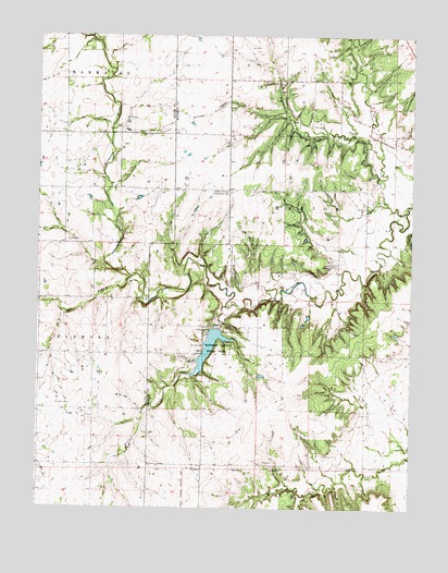
Moran SE, KS USGS Topographic Map
Click on map above to begin viewing in our Map Viewer.

This topographic map contains these locations and features:
Feature Name Type Latitude Longitude GNIS ID View Map
Blazing Star School (historical)SchoolN37.7981°W95.0700°482828View Map
Bourbon County State LakeReservoirN37.7973°W95.0653°479869View Map
Bourbon County State Lake DamDamN37.7973°W95.0653°479870View Map
Bourbon County State ParkParkN37.7925°W95.0672°474744View Map
Bourbon State Fishing Lake and Wildlife RefugeParkN37.7925°W95.0672°479807View Map
Concord School (historical)SchoolN37.7648°W95.0155°482831View Map
East Victory School (historical)SchoolN37.8634°W95.0347°482835View Map
Hatch CemeteryCemeteryN37.8316°W95.0128°474745View Map
Jackie Branch Marmaton RiverStreamN37.8112°W95.0936°474743View Map
Moline School (historical)SchoolN37.7864°W95.1061°482822View Map
Rockford (historical)Populated PlaceN37.7584°W95.0503°485538View Map
Rockford Post Office (historical)Post OfficeN37.7584°W95.0503°485537View Map
Rocklow School (historical)SchoolN37.8487°W95.1072°482808View Map
Rocky Point School (historical)SchoolN37.8492°W95.0061°482869View Map
Schubert CreekStreamN37.8431°W95.0108°482727View Map
South Fairview Community HallBuildingN37.8342°W95.0619°474740View Map
South Fairview School (historical)SchoolN37.8339°W95.0619°482874View Map
Sweet BranchStreamN37.8673°W95.1111°474523View Map
Tennyson CreekStreamN37.8284°W95.0022°482726View Map
West Bethel Community HallBuildingN37.8153°W95.0269°474739View Map
West Bethel School (historical)SchoolN37.8148°W95.0250°482881View Map
Wolfpen CreekStreamN37.8034°W95.0622°474742View Map

Note: Coordinates in the location and feature list above are referenced to NAD83 datum.


Copyright (C) 2008-2024 Ryan Niemi / Sunset Dynamics ... All Rights Reserved