TopoQuest Logo
Do you find TopoQuest useful?
Help keep TopoQuest running and adding new maps/features by donating!
Bitcoin:  19c7KJd3qBynnjoSw5npx9KScwjBe4ifkT
Litecoin:  LXs6TkuXGGXo1vDsWCkWVdjQX94eUKd6ui
Home View Maps Find Maps Find Places Resources & Links


Uniontown, Kansas Topographic Map

USGS Map Title: Uniontown, KS
USGS Map MRC: 37094G8
DRG (GeoTIFF) Download: o37094g8.tif


Neighboring USGS Topographic Map Quads:


  Bronson, KS  
37095H1
 

  Xenia, KS  
37094H8
 

  Devon, KS  
37094H7
 

  Moran SE, KS  
37095G1
 

  Uniontown, KS  
37094G8
 

  Marmaton, KS  
37094G7
 

  Porterville, KS  
37095F1
 

  Hepler, KS  
37094F8
 

  Hiattville, KS  
37094F7


Map MRC Location:

N38°
W95°
N38°
W94°
H8 H7 H6 H5 H4 H3 H2 H1
G8 G7 G6 G5 G4 G3 G2 G1
F8 F7 F6 F5 F4 F3 F2 F1
E8 E7 E6 E5 E4 E3 E2 E1
D8 D7 D6 D5 D4 D3 D2 D1
C8 C7 C6 C5 C4 C3 C2 C1
B8 B7 B6 B5 B4 B3 B2 B1
A8 A7 A6 A5 A4 A3 A2 A1
N37°
W95°
N37°
W94°

Uniontown, KS USGS 1:24K Topographic Map Preview:
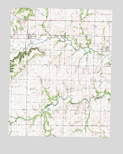
Uniontown, KS USGS Topographic Map
Click on map above to begin viewing in our Map Viewer.

This topographic map contains these locations and features:
Feature Name Type Latitude Longitude GNIS ID View Map
Beachner Grain Elevator Number 16LocaleN37.8455°W94.9755°2695122View Map
Bourbon County Fire District 3 Station 1BuildingN37.8467°W94.9777°2111141View Map
Bourbon County Fire District 4 Redfield StationBuildingN37.8376°W94.8820°2111140View Map
Bunion CreekStreamN37.7845°W94.9016°474747View Map
City of RedfieldCivilN37.8365°W94.8814°2396341View Map
City of UniontownCivilN37.8473°W94.9759°2397088View Map
East Fairview School (historical)SchoolN37.8550°W94.9327°482834View Map
First Missionary Baptist ChurchChurchN37.8461°W94.9769°2689008View Map
Goff School (historical)SchoolN37.8339°W94.9511°482841View Map
Harrison School (historical)SchoolN37.7759°W94.8869°482844View Map
Hinton CreekStreamN37.7706°W94.9594°482732View Map
Lake Side (historical)LocaleN37.8056°W94.9516°482166View Map
Marion CemeteryCemeteryN37.7973°W94.9250°474750View Map
Marion School (historical)SchoolN37.7995°W94.9241°482852View Map
Mount Orum CemeteryCemeteryN37.8136°W94.8974°2673204View Map
Mount Orum ChurchChurchN37.8131°W94.8974°474751View Map
Mount Zion CemeteryCemeteryN37.8182°W94.9153°474752View Map
Opossum HollowValleyN37.8674°W94.9560°474532View Map
Orion School (historical)SchoolN37.7762°W94.9791°482859View Map
Paint Creek Church of the BrethrenChurchN37.7963°W94.9248°474749View Map
PetersburgPopulated PlaceN37.7759°W94.9794°484696View Map
RedfieldPopulated PlaceN37.8367°W94.8811°474753View Map
Redfield Wastewater PlantLocaleN37.8384°W94.8886°2691907View Map
Rolling Prairie School (historical)SchoolN37.7609°W94.9333°482870View Map
Square Top School (historical)SchoolN37.8050°W94.9791°482875View Map
Township of MarionCivilN37.8342°W94.9918°474535View Map
Turkey CreekStreamN37.8467°W94.9497°474533View Map
Union School (historical)SchoolN37.8156°W94.8875°482879View Map
UniontownPopulated PlaceN37.8473°W94.9752°474755View Map
Uniontown CemeteryCemeteryN37.8492°W94.9653°2673205View Map
Uniontown High SchoolSchoolN37.8494°W94.9722°480981View Map
Uniontown Sewer Treatment PlantLocaleN37.8441°W94.9669°2692149View Map
United Methodist Church of RedfieldChurchN37.8376°W94.8805°2689242View Map
United Methodist Church of UniontownChurchN37.8493°W94.9774°2689243View Map
Walnut CreekStreamN37.8359°W94.9025°474531View Map
West Bourbon Elementary SchoolSchoolN37.8480°W94.9716°480982View Map
Woods CemeteryCemeteryN37.8491°W94.8961°474754View Map

Note: Coordinates in the location and feature list above are referenced to NAD83 datum.


Copyright (C) 2008-2024 Ryan Niemi / Sunset Dynamics ... All Rights Reserved