TopoQuest Logo
Do you find TopoQuest useful?
Help keep TopoQuest running and adding new maps/features by donating!
Bitcoin:  19c7KJd3qBynnjoSw5npx9KScwjBe4ifkT
Litecoin:  LXs6TkuXGGXo1vDsWCkWVdjQX94eUKd6ui
Home View Maps Find Maps Find Places Resources & Links


Hepler, Kansas Topographic Map

USGS Map Title: Hepler, KS
USGS Map MRC: 37094F8
DRG (GeoTIFF) Download: o37094f8.tif


Neighboring USGS Topographic Map Quads:


  Moran SE, KS  
37095G1
 

  Uniontown, KS  
37094G8
 

  Marmaton, KS  
37094G7
 

  Porterville, KS  
37095F1
 

  Hepler, KS  
37094F8
 

  Hiattville, KS  
37094F7
 

  Walnut, KS  
37095E1
 

  Brazilton, KS  
37094E8
 

  Girard, KS  
37094E7


Map MRC Location:

N38°
W95°
N38°
W94°
H8 H7 H6 H5 H4 H3 H2 H1
G8 G7 G6 G5 G4 G3 G2 G1
F8 F7 F6 F5 F4 F3 F2 F1
E8 E7 E6 E5 E4 E3 E2 E1
D8 D7 D6 D5 D4 D3 D2 D1
C8 C7 C6 C5 C4 C3 C2 C1
B8 B7 B6 B5 B4 B3 B2 B1
A8 A7 A6 A5 A4 A3 A2 A1
N37°
W95°
N37°
W94°

Hepler, KS USGS 1:24K Topographic Map Preview:
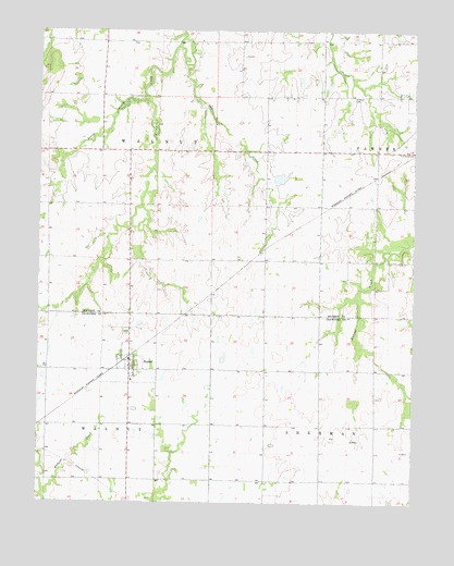
Hepler, KS USGS Topographic Map
Click on map above to begin viewing in our Map Viewer.

This topographic map contains these locations and features:
Feature Name Type Latitude Longitude GNIS ID View Map
Arlington School (historical)SchoolN37.7245°W94.9250°483300View Map
City of HeplerCivilN37.6620°W94.9696°2394357View Map
Cleveland School (historical)SchoolN37.6309°W94.9061°483503View Map
Gibson School (historical)SchoolN37.7253°W94.9800°483303View Map
Green Valley School (historical)SchoolN37.7470°W94.9969°485366View Map
HeplerPopulated PlaceN37.6612°W94.9683°474993View Map
Hepler CemeteryCemeteryN37.6701°W94.9707°2739723View Map
Hepler City and Rural Fire DepartmentBuildingN37.6620°W94.9698°2111412View Map
Hepler City HallBuildingN37.6598°W94.9701°2693154View Map
Hepler City LibraryBuildingN37.6598°W94.9701°2694648View Map
Hepler Post OfficePost OfficeN37.6623°W94.9697°2693765View Map
Hepler Seventh Day Adventist ChurchChurchN37.6610°W94.9698°2690108View Map
Hepler Sewer Treatment PlantLocaleN37.6559°W94.9613°2691971View Map
Hiattville CemeteryCemeteryN37.7191°W94.8792°474996View Map
Lone Elm School (historical)SchoolN37.6892°W94.9250°483308View Map
Maple Grove School (historical)SchoolN37.6598°W94.9247°483535View Map
Mount Hope School (historical)SchoolN37.6973°W94.8883°483309View Map
Owl CreekStreamN37.7459°W94.9544°474995View Map
Pleasant Valley School (historical)SchoolN37.6895°W94.9972°483312View Map
Prong CreekStreamN37.7328°W94.9655°474992View Map
Saint Mary CemeteryCemeteryN37.7325°W94.8959°474994View Map
Star of Hope School (historical)SchoolN37.6312°W94.9700°483567View Map
Township of WalnutCivilN37.7181°W94.9970°474748View Map
Victory School (historical)SchoolN37.6603°W94.8880°483570View Map

Note: Coordinates in the location and feature list above are referenced to NAD83 datum.


Copyright (C) 2008-2024 Ryan Niemi / Sunset Dynamics ... All Rights Reserved