TopoQuest Logo
Do you find TopoQuest useful?
Help keep TopoQuest running and adding new maps/features by donating!
Bitcoin:  19c7KJd3qBynnjoSw5npx9KScwjBe4ifkT
Litecoin:  LXs6TkuXGGXo1vDsWCkWVdjQX94eUKd6ui
Home View Maps Find Maps Find Places Resources & Links


Morley, Iowa Topographic Map

USGS Map Title: Morley, IA
USGS Map MRC: 42091A2
DRG (GeoTIFF) Download: o42091a2.tif


Neighboring USGS Topographic Map Quads:


  Anamosa NE, IA  
42091B3
 

  Monticello, IA  
42091B2
 

  Scotch Grove, IA  
42091B1
 

  Anamosa, IA  
42091A3
 

  Morley, IA  
42091A2
 

  Wyoming West, IA  
42091A1
 

  Mechanicsville, IA  
41091H3
 

  Stanwood, IA  
41091H2
 

  Clarence, IA  
41091H1


Map MRC Location:

N43°
W92°
N43°
W91°
H8 H7 H6 H5 H4 H3 H2 H1
G8 G7 G6 G5 G4 G3 G2 G1
F8 F7 F6 F5 F4 F3 F2 F1
E8 E7 E6 E5 E4 E3 E2 E1
D8 D7 D6 D5 D4 D3 D2 D1
C8 C7 C6 C5 C4 C3 C2 C1
B8 B7 B6 B5 B4 B3 B2 B1
A8 A7 A6 A5 A4 A3 A2 A1
N42°
W92°
N42°
W91°

Morley, IA USGS 1:24K Topographic Map Preview:
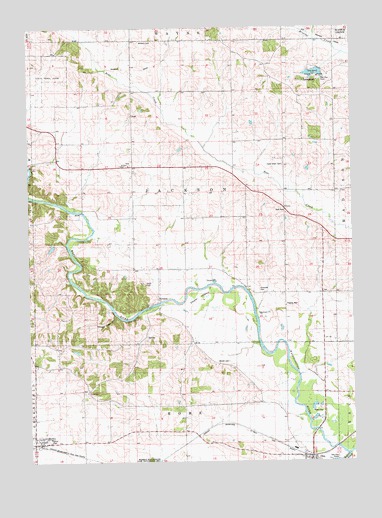
Morley, IA USGS Topographic Map
Click on map above to begin viewing in our Map Viewer.

This topographic map contains these locations and features:
Feature Name Type Latitude Longitude GNIS ID View Map
Antioch CemeteryCemeteryN42.0856°W91.2113°2001879View Map
Antioch ChurchChurchN42.0858°W91.2115°454201View Map
Antioch SchoolSchoolN42.0861°W91.2143°454203View Map
Cedar IslandIslandN42.0475°W91.1840°455246View Map
Center CemeteryCemeteryN42.0203°W91.2290°2001875View Map
Center ChurchChurchN42.0192°W91.2268°455279View Map
Central ParkParkN42.1111°W91.1390°2001892View Map
Central Park LakeReservoirN42.1118°W91.1393°463478View Map
Central Park Lake DamDamN42.1125°W91.1371°463482View Map
City of MorleyCivilN42.0060°W91.2459°2395403View Map
Faith United Methodist ChurchChurchN42.0061°W91.2463°2001869View Map
Fremont Mill BridgeBridgeN42.1111°W91.1393°2001893View Map
Glenn Cemetery (historical)CemeteryN42.0417°W91.1418°2001878View Map
Goose Pond (historical)LakeN42.0195°W91.2357°465529View Map
Grafft CemeteryCemeteryN42.0515°W91.2051°457011View Map
Green Center CemeteryCemeteryN42.0202°W91.2288°455273View Map
Hazel Green CemeteryCemeteryN42.0853°W91.1510°457361View Map
Hogs Den HollowValleyN42.0423°W91.2170°457545View Map
Iowa State Penal FarmLocaleN42.1125°W91.2418°1825084View Map
Isabell (historical)LocaleN42.0820°W91.1474°466159View Map
Isabell Post Office (historical)Post OfficeN42.0778°W91.1515°2001794View Map
Jones CountyCivilN42.1212°W91.1314°465241View Map
Merritt CemeteryCemeteryN42.0289°W91.1734°459008View Map
Midland CemeteryCemeteryN42.1212°W91.2024°459065View Map
Miller ParkParkN42.0058°W91.2427°1825083View Map
MorleyPopulated PlaceN42.0061°W91.2463°459231View Map
Morley (historical)LocaleN42.0047°W91.2463°2001872View Map
Morley City HallBuildingN42.0061°W91.2463°2001868View Map
Morley Community BuildingBuildingN42.0061°W91.2463°2001870View Map
Morley Fire Department First RespondersBuildingN42.0058°W91.2439°2577407View Map
Morley LibraryBuildingN42.0061°W91.2463°2001871View Map
Morley Post OfficePost OfficeN42.0061°W91.2463°2001867View Map
NewportPopulated PlaceN42.0453°W91.2007°464668View Map
Olin (historical)LocaleN42.0014°W91.1418°2001847View Map
Olin Ambulance ServiceBuildingN42.0004°W91.1426°2599868View Map
Olin Hose CompanyBuildingN42.0004°W91.1426°2001838View Map
Olin Recreation Area AccessLocaleN42.0106°W91.1413°2001726View Map
Pleasant Valley CemeteryCemeteryN42.0495°W91.1613°460660View Map
Township of JacksonCivilN42.0776°W91.1901°468105View Map
Walnut CreekStreamN42.0022°W91.1271°462638View Map
WaysideLocaleN42.0722°W91.1502°462765View Map

Note: Coordinates in the location and feature list above are referenced to NAD83 datum.


Copyright (C) 2008-2024 Ryan Niemi / Sunset Dynamics ... All Rights Reserved