TopoQuest Logo
Do you find TopoQuest useful?
Help keep TopoQuest running and adding new maps/features by donating!
Bitcoin:  19c7KJd3qBynnjoSw5npx9KScwjBe4ifkT
Litecoin:  LXs6TkuXGGXo1vDsWCkWVdjQX94eUKd6ui
Home View Maps Find Maps Find Places Resources & Links


Wyoming West, Iowa Topographic Map

USGS Map Title: Wyoming West, IA
USGS Map MRC: 42091A1
DRG (GeoTIFF) Download: o42091a1.tif


Neighboring USGS Topographic Map Quads:


  Monticello, IA  
42091B2
 

  Scotch Grove, IA  
42091B1
 

  Canton, IA  
42090B8
 

  Morley, IA  
42091A2
 

  Wyoming West, IA  
42091A1
 

  Wyoming East, IA  
42090A8
 

  Stanwood, IA  
41091H2
 

  Clarence, IA  
41091H1
 

  Oxford Junction, IA  
41090H8


Map MRC Location:

N43°
W92°
N43°
W91°
H8 H7 H6 H5 H4 H3 H2 H1
G8 G7 G6 G5 G4 G3 G2 G1
F8 F7 F6 F5 F4 F3 F2 F1
E8 E7 E6 E5 E4 E3 E2 E1
D8 D7 D6 D5 D4 D3 D2 D1
C8 C7 C6 C5 C4 C3 C2 C1
B8 B7 B6 B5 B4 B3 B2 B1
A8 A7 A6 A5 A4 A3 A2 A1
N42°
W92°
N42°
W91°

Wyoming West, IA USGS 1:24K Topographic Map Preview:
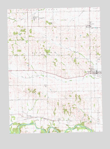
Wyoming West, IA USGS Topographic Map
Click on map above to begin viewing in our Map Viewer.

This topographic map contains these locations and features:
Feature Name Type Latitude Longitude GNIS ID View Map
Calvary Baptist ChurchChurchN42.1053°W91.0179°2001861View Map
Center JunctionPopulated PlaceN42.1161°W91.0871°455289View Map
Center Junction (historical)LocaleN42.1175°W91.0876°2001865View Map
Center Junction Census Designated PlaceCensusN42.1141°W91.0903°2783850View Map
Center Junction Community BuildingBuildingN42.1161°W91.0871°2001864View Map
Center Junction Fire DepartmentBuildingN42.1148°W91.0905°2001863View Map
Center Junction Post OfficePost OfficeN42.1161°W91.0871°2001862View Map
Chamberlain ParkParkN42.1036°W91.0126°1825082View Map
City of Center Junction (historical)CivilN42.1158°W91.0904°2393780View Map
City of OnslowCivilN42.1073°W91.0153°2396069View Map
City of WyomingCivilN42.0597°W91.0051°2397389View Map
HalePopulated PlaceN42.0125°W91.0593°457200View Map
Hale (historical)LocaleN42.0097°W91.0593°2001787View Map
Hale BridgeBridgeN42.0045°W91.0643°2001891View Map
Hale CemeteryCemeteryN42.0160°W91.0590°457201View Map
Hale Post Office (historical)Post OfficeN42.0125°W91.0593°2001786View Map
Little Bear Country ClubLocaleN42.0647°W91.0138°2001826View Map
Little Bear CreekStreamN42.0556°W91.0026°458437View Map
Lutheran ChurchChurchN42.0597°W91.0090°2001823View Map
Madison (historical)LocaleN42.0639°W91.0988°466158View Map
Madison Center CemeteryCemeteryN42.0778°W91.0757°458720View Map
Madison Post Office (historical)Post OfficeN42.0639°W91.0988°2001785View Map
Madison Village CemeteryCemeteryN42.0695°W91.1029°2001873View Map
Maquoketa Medical Associates CenterHospitalN42.0595°W91.0013°2001817View Map
Methodist ChurchChurchN42.0597°W91.0063°2001822View Map
Midland Community AmbulanceBuildingN42.0585°W91.0061°2599776View Map
Midland Middle / High SchoolSchoolN42.0611°W91.0069°2001825View Map
North Madison Pioneer CemeteryCemeteryN42.1100°W91.0640°459604View Map
OnslowPopulated PlaceN42.1070°W91.0151°459871View Map
Onslow (historical)LocaleN42.1075°W91.0149°2001855View Map
Onslow Ball ParkParkN42.1042°W91.0126°2001859View Map
Onslow Elementary SchoolSchoolN42.1053°W91.0188°2001858View Map
Onslow Fire Department and First RespondersBuildingN42.1057°W91.0142°2001857View Map
Onslow Post OfficePost OfficeN42.1072°W91.0143°2001856View Map
Presbyterian ChurchChurchN42.0600°W91.0115°2001824View Map
Presbyterian ChurchChurchN42.1097°W91.0140°2001860View Map
Presbyterian ChurchChurchN42.1139°W91.0890°2001866View Map
Township of MadisonCivilN42.0776°W91.0731°468323View Map
WyomingPopulated PlaceN42.0592°W91.0074°463225View Map
Wyoming (historical)LocaleN42.0597°W91.0043°2001818View Map
Wyoming CemeteryCemeteryN42.0642°W91.0151°463226View Map
Wyoming City HallBuildingN42.0586°W91.0065°2001819View Map
Wyoming Historical MuseumBuildingN42.0586°W91.0065°2001820View Map
Wyoming LibraryBuildingN42.0586°W91.0065°2001821View Map
Wyoming Post OfficePost OfficeN42.0586°W91.0051°2001816View Map

Note: Coordinates in the location and feature list above are referenced to NAD83 datum.


Copyright (C) 2008-2024 Ryan Niemi / Sunset Dynamics ... All Rights Reserved