TopoQuest Logo
Do you find TopoQuest useful?
Help keep TopoQuest running and adding new maps/features by donating!
Bitcoin:  19c7KJd3qBynnjoSw5npx9KScwjBe4ifkT
Litecoin:  LXs6TkuXGGXo1vDsWCkWVdjQX94eUKd6ui
Home View Maps Find Maps Find Places Resources & Links


Mount Vernon, Arkansas Topographic Map

USGS Map Title: Mount Vernon, AR
USGS Map MRC: 35092B1
DRG (GeoTIFF) Download: o35092b1.tif


Neighboring USGS Topographic Map Quads:


  Barney, AR  
35092C2
 

  Rose Bud, AR  
35092C1
 

  Sidon, AR  
35091C8
 

  Enola, AR  
35092B2
 

  Mount Vernon, AR  
35092B1
 

  Floyd, AR  
35091B8
 

  Vilonia, AR  
35092A2
 

  Mountain Springs, AR  
35092A1
 

  Beebe, AR  
35091A8


Map MRC Location:

N36°
W93°
N36°
W92°
H8 H7 H6 H5 H4 H3 H2 H1
G8 G7 G6 G5 G4 G3 G2 G1
F8 F7 F6 F5 F4 F3 F2 F1
E8 E7 E6 E5 E4 E3 E2 E1
D8 D7 D6 D5 D4 D3 D2 D1
C8 C7 C6 C5 C4 C3 C2 C1
B8 B7 B6 B5 B4 B3 B2 B1
A8 A7 A6 A5 A4 A3 A2 A1
N35°
W93°
N35°
W92°

Mount Vernon, AR USGS 1:24K Topographic Map Preview:
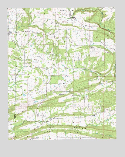
Mount Vernon, AR USGS Topographic Map
Click on map above to begin viewing in our Map Viewer.

This topographic map contains these locations and features:
Feature Name Type Latitude Longitude GNIS ID View Map
Adkisson CemeteryCemeteryN35.1870°W92.1165°45793View Map
Black Jack MountainSummitN35.2084°W92.0096°57386View Map
Blasingame CemeteryCemeteryN35.1451°W92.0776°83369View Map
Bull Creek HillSummitN35.1734°W92.0379°57465View Map
Bull MountainRidgeN35.1356°W92.0399°47170View Map
Clifty CreekStreamN35.2484°W92.0260°47855View Map
El PasoPopulated PlaceN35.1262°W92.0954°76862View Map
El Paso Post OfficePost OfficeN35.1265°W92.0965°84289View Map
Faith Missionary Baptist ChurchChurchN35.2354°W92.0688°83368View Map
First Baptist Church of El PasoChurchN35.1256°W92.0940°65065View Map
Floyd Volunteer Fire Department Station 2BuildingN35.2422°W92.0513°2116433View Map
HammondsvillePopulated PlaceN35.1712°W92.0826°81939View Map
Hammons Chapel CemeteryCemeteryN35.1673°W92.0665°49806View Map
Little CreekStreamN35.1793°W92.1165°51234View Map
Mount VernonPopulated PlaceN35.2265°W92.1240°77748View Map
Mount Vernon Volunteer Fire DepartmentBuildingN35.2254°W92.1237°2116827View Map
Oak Church of ChristChurchN35.1448°W92.0768°77870View Map
Oak Church of ChristChurchN35.1493°W92.0910°83370View Map
Oliver CemeteryCemeteryN35.1887°W92.1074°53043View Map
Powell BranchStreamN35.1948°W92.0007°53737View Map
RomancePopulated PlaceN35.2409°W92.0513°54177View Map
Romance Post OfficePost OfficeN35.2395°W92.0501°84291View Map
Royal Hill Baptist ChurchChurchN35.1476°W92.0276°78225View Map
Smyrna Baptist ChurchChurchN35.1926°W92.0571°78390View Map
Town of Mount VernonCivilN35.2236°W92.1241°2406214View Map
Township of ClevelandCivilN35.1611°W92.0403°69821View Map
Township of JeffersonCivilN35.1875°W92.0794°69840View Map
Township of MarshallCivilN35.2385°W92.0630°69847View Map
Tucker BluffCliffN35.1504°W92.1101°55676View Map
Union Hill ChurchChurchN35.1756°W92.1107°55826View Map

Note: Coordinates in the location and feature list above are referenced to NAD83 datum.


Copyright (C) 2008-2024 Ryan Niemi / Sunset Dynamics ... All Rights Reserved