TopoQuest Logo
Do you find TopoQuest useful?
Help keep TopoQuest running and adding new maps/features by donating!
Bitcoin:  19c7KJd3qBynnjoSw5npx9KScwjBe4ifkT
Litecoin:  LXs6TkuXGGXo1vDsWCkWVdjQX94eUKd6ui
Home View Maps Find Maps Find Places Resources & Links


Mount Blanchard, Ohio Topographic Map

USGS Map Title: Mount Blanchard, OH
USGS Map MRC: 40083H5
DRG (GeoTIFF) Download: o40083h5.tif


Neighboring USGS Topographic Map Quads:


  Findlay, OH  
41083A6
 

  Arcadia, OH  
41083A5
 

  Alvada, OH  
41083A4
 

  Arlington, OH  
40083H6
 

  Mount Blanchard, OH  
40083H5
 

  Carey, OH  
40083H4
 

  Dunkirk, OH  
40083G6
 

  Forest, OH  
40083G5
 

  Wharton, OH  
40083G4


Map MRC Location:

N41°
W84°
N41°
W83°
H8 H7 H6 H5 H4 H3 H2 H1
G8 G7 G6 G5 G4 G3 G2 G1
F8 F7 F6 F5 F4 F3 F2 F1
E8 E7 E6 E5 E4 E3 E2 E1
D8 D7 D6 D5 D4 D3 D2 D1
C8 C7 C6 C5 C4 C3 C2 C1
B8 B7 B6 B5 B4 B3 B2 B1
A8 A7 A6 A5 A4 A3 A2 A1
N40°
W84°
N40°
W83°

Mount Blanchard, OH USGS 1:24K Topographic Map Preview:
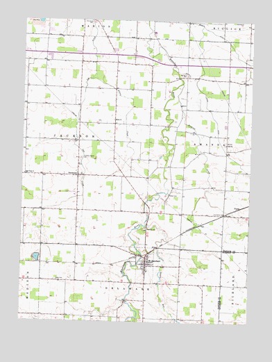
Mount Blanchard, OH USGS Topographic Map
Click on map above to begin viewing in our Map Viewer.

This topographic map contains these locations and features:
Feature Name Type Latitude Longitude GNIS ID View Map
Brights DitchCanalN40.9923°W83.5133°1038315View Map
Buckrun CreekStreamN40.9739°W83.5372°1038485View Map
Castor CemeteryCemeteryN40.8920°W83.6044°1038871View Map
Delaware Township Fire DepartmentBuildingN40.8991°W83.5557°2549599View Map
Eagle Creek ChurchChurchN40.9359°W83.6235°1039922View Map
Elm Grove CemeteryCemeteryN40.9988°W83.5882°1040158View Map
Five Points CemeteryCemeteryN40.9201°W83.5141°1040484View Map
Folk School (historical)SchoolN40.9826°W83.5822°1054436View Map
Frontiers Repose CemeteryCemeteryN40.9428°W83.5921°1040707View Map
Hagerty Airport (historical)AirportN40.9717°W83.5485°1083077View Map
HoucktownPopulated PlaceN40.9353°W83.5941°1064868View Map
Houcktown Post Office (historical)Post OfficeN40.9348°W83.5944°1990257View Map
Island ParkParkN40.9012°W83.5585°1730832View Map
Krout CemeteryCemeteryN40.9137°W83.5560°1730686View Map
Lackery School (historical)SchoolN40.8953°W83.5952°1054440View Map
Lee CemeteryCemeteryN40.9500°W83.5135°1048339View Map
Lutz AirportAirportN40.9639°W83.5952°1082681View Map
Miller School (historical)SchoolN40.9753°W83.5124°1054447View Map
Mount BlanchardPopulated PlaceN40.8984°W83.5560°1043538View Map
Mount Blanchard Branch LibraryBuildingN40.8984°W83.5566°1084399View Map
Mount Blanchard CemeteryCemeteryN40.9037°W83.5521°1730689View Map
Mount Blanchard Elementary SchoolSchoolN40.8959°W83.5560°1054448View Map
Mount Blanchard Nazarene ChurchChurchN40.8962°W83.5566°1071956View Map
Mount Blanchard Post OfficePost OfficeN40.8987°W83.5555°1990234View Map
Mount Blanchard United Methodist ChurchChurchN40.8978°W83.5566°1071957View Map
Potato RunStreamN40.9156°W83.5558°1066149View Map
PrattsPopulated PlaceN40.9226°W83.5044°1062953View Map
Riverdale High SchoolSchoolN40.8962°W83.5558°1054450View Map
Riverview CemeteryCemeteryN40.9137°W83.5563°1045068View Map
Salem CemeteryCemeteryN40.9589°W83.5752°1730690View Map
Siddall CemeteryCemeteryN40.9279°W83.5444°1046256View Map
Silver CreekStreamN40.9776°W83.5847°1046272View Map
Stahl DitchCanalN40.9609°W83.5208°1046619View Map
Township of AmandaCivilN40.9508°W83.5110°1086239View Map
Township of JacksonCivilN40.9499°W83.6032°1086246View Map
Treece School (historical)SchoolN40.9164°W83.6238°1054454View Map
Union ChurchChurchN40.9487°W83.5130°1047317View Map
Van Horn CemeteryCemeteryN40.9773°W83.5349°1047416View Map
Village of Mount BlanchardCivilN40.8985°W83.5568°2399407View Map
WKXA-FM (Findlay)TowerN40.9167°W83.5958°1085355View Map

Note: Coordinates in the location and feature list above are referenced to NAD83 datum.


Copyright (C) 2008-2024 Ryan Niemi / Sunset Dynamics ... All Rights Reserved