TopoQuest Logo
Do you find TopoQuest useful?
Help keep TopoQuest running and adding new maps/features by donating!
Bitcoin:  19c7KJd3qBynnjoSw5npx9KScwjBe4ifkT
Litecoin:  LXs6TkuXGGXo1vDsWCkWVdjQX94eUKd6ui
Home View Maps Find Maps Find Places Resources & Links


Munford, Alabama Topographic Map

USGS Map Title: Munford, AL
USGS Map MRC: 33085E8
DRG (GeoTIFF) Download: o33085e8.tif


Neighboring USGS Topographic Map Quads:


  Francis Mill, AL  
33086F1
 

  Eulaton, AL  
33085F8
 

  Anniston, AL  
33085F7
 

  Eastaboga, AL  
33086E1
 

  Munford, AL  
33085E8
 

  Oxford, AL  
33085E7
 

  Talladega, AL  
33086D1
 

  Ironaton, AL  
33085D8
 

  Cheaha Mountain, AL  
33085D7


Map MRC Location:

N34°
W86°
N34°
W85°
H8 H7 H6 H5 H4 H3 H2 H1
G8 G7 G6 G5 G4 G3 G2 G1
F8 F7 F6 F5 F4 F3 F2 F1
E8 E7 E6 E5 E4 E3 E2 E1
D8 D7 D6 D5 D4 D3 D2 D1
C8 C7 C6 C5 C4 C3 C2 C1
B8 B7 B6 B5 B4 B3 B2 B1
A8 A7 A6 A5 A4 A3 A2 A1
N33°
W86°
N33°
W85°

Munford, AL USGS 1:24K Topographic Map Preview:
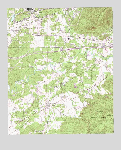
Munford, AL USGS Topographic Map
Click on map above to begin viewing in our Map Viewer.

This topographic map contains these locations and features:
Feature Name Type Latitude Longitude GNIS ID View Map
Anna Thomas Memorial Baptist ChurchChurchN33.5496°W85.9358°162388View Map
Anniston Army Depot Fire Department Station 1BuildingN33.6205°W85.9702°2683463View Map
Anniston Army Depot Fire Department Station 2BuildingN33.6205°W85.9702°2683462View Map
Antioch Baptist ChurchChurchN33.6076°W85.9805°159074View Map
Antioch CemeteryCemeteryN33.6054°W85.9791°159067View Map
BethlehemPopulated PlaceN33.5034°W85.9614°162394View Map
Bethlehem Methodist ChurchChurchN33.5015°W85.9586°159164View Map
Bettaview Congregational ChurchChurchN33.5948°W85.8822°162141View Map
Bettaview Hills ChurchChurchN33.5932°W85.8808°140811View Map
Block Memorial Baptist ChurchChurchN33.5668°W85.9711°159568View Map
Burns CrossroadPopulated PlaceN33.6201°W85.9416°159277View Map
BynumPopulated PlaceN33.6132°W85.9611°159290View Map
Bynum Baptist ChurchChurchN33.6137°W85.9652°162148View Map
Bynum Census Designated Place (historical)CensusN33.6078°W85.9582°2402740View Map
Bynum Methodist ChurchChurchN33.6145°W85.9677°162149View Map
Bynum Post OfficePost OfficeN33.6135°W85.9606°2789052View Map
Camp MaddisonLocaleN33.5537°W85.9664°162407View Map
Castleberry BranchStreamN33.6220°W85.9333°162843View Map
Choccolocco LakeReservoirN33.6135°W85.9940°161448View Map
Choccolocco Mills (historical)LocaleN33.5623°W85.9652°162414View Map
Church of ChristChurchN33.5454°W85.9458°162415View Map
ColdwaterPopulated PlaceN33.5862°W85.9183°159427View Map
Coldwater Baptist ChurchChurchN33.5884°W85.9208°162162View Map
Coldwater Camp (historical)LocaleN33.6043°W85.9264°162849View Map
Coldwater CemeteryCemeteryN33.5882°W85.9202°1730336View Map
Coldwater Covered BridgeBridgeN33.5859°W85.9130°162850View Map
Coldwater Creek Shopping CenterLocaleN33.5982°W85.9422°162163View Map
Coldwater Elementary SchoolSchoolN33.6023°W85.9361°162164View Map
Coldwater SchoolSchoolN33.6007°W85.9355°159429View Map
Coldwater SpringSpringN33.6037°W85.9261°159430View Map
Coldwater Spring BranchStreamN33.5798°W85.9161°162418View Map
Coldwater StationLocaleN33.6048°W85.9289°159431View Map
Coldwater United Methodist ChurchChurchN33.5937°W85.9233°162165View Map
De Soto ManorPopulated PlaceN33.6223°W85.9736°162172View Map
DeSoto Manor SchoolSchoolN33.6148°W85.9655°159493View Map
Fairview ChurchChurchN33.5918°W85.8930°162174View Map
Ganaway Gin (historical)LocaleN33.5493°W85.8944°162435View Map
Garret Lake Number 2ReservoirN33.5384°W85.8833°161420View Map
Garrett Lake Number 1ReservoirN33.5397°W85.8787°161421View Map
GauldinvillePopulated PlaceN33.6223°W85.9236°162182View Map
Grant TownPopulated PlaceN33.5409°W85.9500°162441View Map
Grants PondLakeN33.5431°W85.9649°162442View Map
Hall GrovePopulated PlaceN33.5176°W85.9827°162447View Map
Halls Grove ChurchChurchN33.5179°W85.9822°159709View Map
Hawkins SchoolSchoolN33.6159°W85.9569°159739View Map
Henderson LakeReservoirN33.5174°W85.9214°162450View Map
Hillside SchoolSchoolN33.5168°W85.9825°159778View Map
Interchange 179CrossingN33.5843°W85.9255°163041View Map
JeniferPopulated PlaceN33.5493°W85.9364°159858View Map
KnoxvillePopulated PlaceN33.5918°W85.8972°162864View Map
Letcher (historical)LocaleN33.5645°W85.9027°162469View Map
Little Texas ChurchChurchN33.5182°W85.9966°137249View Map
McKibbons Mill (historical)LocaleN33.5612°W85.9380°162481View Map
MunfordPopulated PlaceN33.5298°W85.9508°160206View Map
Munford Census Designated Place (historical)CensusN33.5368°W85.9560°2403318View Map
Munford DivisionCivilN33.5381°W85.9198°165961View Map
Munford High SchoolSchoolN33.5301°W85.9530°162493View Map
Munford Post OfficePost OfficeN33.5283°W85.9485°2789017View Map
Munford Volunteer Fire DepartmentBuildingN33.5301°W85.9545°2682880View Map
New Bethel Baptist ChurchChurchN33.5862°W85.9486°162205View Map
New HavenPopulated PlaceN33.6237°W85.9166°162872View Map
New Haven Baptist ChurchChurchN33.6245°W85.9180°160233View Map
New Hope Baptist ChurchChurchN33.6176°W85.9533°160239View Map
Ophelia S Hill Elementary SchoolSchoolN33.5459°W85.9450°162452View Map
Oxford Fire Department Station 3BuildingN33.5964°W85.9319°2682898View Map
Plum Springs (historical)SchoolN33.6057°W85.9866°165637View Map
RicheytownPopulated PlaceN33.5668°W85.9666°162517View Map
Rocky Mount Baptist ChurchChurchN33.5904°W85.8947°162227View Map
Salt CreekStreamN33.5609°W85.9355°160553View Map
Salt Creek FallsFallsN33.5015°W85.9047°162524View Map
Shiloh Baptist ChurchChurchN33.5665°W85.8872°162528View Map
Shiloh CemeteryCemeteryN33.5662°W85.9036°162242View Map
Silver RunPopulated PlaceN33.5651°W85.9080°160610View Map
Silver Run CreekStreamN33.5620°W85.9339°162530View Map
Silver Run SchoolSchoolN33.5471°W85.8961°160611View Map
Snows BranchStreamN33.5770°W85.8944°162532View Map
Sportsmen Club DamDamN33.6118°W85.9933°161449View Map
Springhill Baptist ChurchChurchN33.6159°W85.9536°162231View Map
Springhill Christian Methodist Episcopal ChurchChurchN33.5465°W85.9405°162537View Map
Stewarts LakeReservoirN33.5294°W85.9042°161419View Map
Sweet HomePopulated PlaceN33.5557°W85.9000°162543View Map
Sweet Home Baptist ChurchChurchN33.5562°W85.9011°162544View Map
Sweet Home SchoolSchoolN33.5557°W85.9008°160699View Map
Tarsus (historical)Populated PlaceN33.6223°W85.9561°162232View Map
Town of MunfordCivilN33.5286°W85.9531°2424936View Map
Turnipseed (historical)LocaleN33.5273°W85.9080°162562View Map
Tuskehadky BranchStreamN33.5743°W85.8994°162563View Map

Note: Coordinates in the location and feature list above are referenced to NAD83 datum.


Copyright (C) 2008-2024 Ryan Niemi / Sunset Dynamics ... All Rights Reserved