TopoQuest Logo
Do you find TopoQuest useful?
Help keep TopoQuest running and adding new maps/features by donating!
Bitcoin:  19c7KJd3qBynnjoSw5npx9KScwjBe4ifkT
Litecoin:  LXs6TkuXGGXo1vDsWCkWVdjQX94eUKd6ui
Home View Maps Find Maps Find Places Resources & Links


Newark, Illinois Topographic Map

USGS Map Title: Newark, IL
USGS Map MRC: 41088E5
DRG (GeoTIFF) Download: o41088e5.tif


Neighboring USGS Topographic Map Quads:


  Somonauk, IL  
41088F6
 

  Plano, IL  
41088F5
 

  Yorkville, IL  
41088F4
 

  Sheridan, IL  
41088E6
 

  Newark, IL  
41088E5
 

  Plattville, IL  
41088E4
 

  Serena, IL  
41088D6
 

  Stavanger, IL  
41088D5
 

  Lisbon, IL  
41088D4


Map MRC Location:

N42°
W89°
N42°
W88°
H8 H7 H6 H5 H4 H3 H2 H1
G8 G7 G6 G5 G4 G3 G2 G1
F8 F7 F6 F5 F4 F3 F2 F1
E8 E7 E6 E5 E4 E3 E2 E1
D8 D7 D6 D5 D4 D3 D2 D1
C8 C7 C6 C5 C4 C3 C2 C1
B8 B7 B6 B5 B4 B3 B2 B1
A8 A7 A6 A5 A4 A3 A2 A1
N41°
W89°
N41°
W88°

Newark, IL USGS 1:24K Topographic Map Preview:
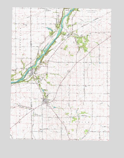
Newark, IL USGS Topographic Map
Click on map above to begin viewing in our Map Viewer.

This topographic map contains these locations and features:
Feature Name Type Latitude Longitude GNIS ID View Map
Ackleys RunStreamN41.5978°W88.5415°1808690View Map
Anderson School (historical)SchoolN41.5517°W88.5476°1718833View Map
Asbury School (historical)SchoolN41.5881°W88.6009°1718837View Map
Big Grove (historical)WoodsN41.5156°W88.5412°1808697View Map
Clear CreekStreamN41.5692°W88.5959°406200View Map
Cushing Field LtdAirportN41.5211°W88.6041°427599View Map
Darnell CemeteryCemeteryN41.6111°W88.5651°406955View Map
Fern Dell School (historical)SchoolN41.5100°W88.5848°1718831View Map
Greenfield School (historical)SchoolN41.6245°W88.5745°1718835View Map
Helmar Lutheran CemeteryCemeteryN41.5444°W88.5031°410041View Map
Hemmingsen AirportAirportN41.5946°W88.6077°427788View Map
Hollenback CreekStreamN41.6178°W88.5556°410395View Map
Hollenback School (historical)SchoolN41.5786°W88.5340°1718834View Map
Hubbard School (historical)SchoolN41.6161°W88.6212°1718836View Map
Knutson CreekStreamN41.6075°W88.5547°2126977View Map
Little Rock Fox Fire Department Station 2 MillbrookBuildingN41.5993°W88.5537°2681776View Map
McMath School (historical)SchoolN41.5534°W88.6106°1718838View Map
Milhurst LakeReservoirN41.6042°W88.5754°1691569View Map
Milhurst Lake DamDamN41.6034°W88.5767°1691568View Map
MillbrookPopulated PlaceN41.5984°W88.5529°413563View Map
Millbrook Junior High SchoolSchoolN41.5973°W88.5548°1808724View Map
Millbrook Post OfficePost OfficeN41.5990°W88.5544°1808725View Map
MillhurstPopulated PlaceN41.6228°W88.5523°422982View Map
Millhurst Fen Nature PreserveParkN41.6211°W88.5604°1994543View Map
MillingtonPopulated PlaceN41.5625°W88.5984°413615View Map
Millington Post OfficePost OfficeN41.5622°W88.6022°2788307View Map
Millington-Newark CemeteryCemeteryN41.5572°W88.5948°413616View Map
NewarkPopulated PlaceN41.5370°W88.5834°414478View Map
Newark Ambulance DistrictBuildingN41.5373°W88.5819°2673934View Map
Newark Community High SchoolSchoolN41.5420°W88.5792°1808726View Map
Newark Elementary SchoolSchoolN41.5428°W88.5784°1808727View Map
Newark Fire Protection DistrictBuildingN41.5373°W88.5820°2682108View Map
Newark Lutheran ChurchChurchN41.5364°W88.5820°1998711View Map
Newark Post OfficePost OfficeN41.5372°W88.5825°2788751View Map
Pappoose GroveWoodsN41.5864°W88.5579°1808729View Map
Pine Mound CemeteryCemeteryN41.6072°W88.6073°415705View Map
Sleezer School (historical)SchoolN41.5370°W88.5473°1718832View Map
Township of Big GroveCivilN41.5012°W88.5402°428670View Map
Township of FoxCivilN41.5891°W88.5423°429022View Map
Village of MillbrookCivilN41.6050°W88.5449°2399351View Map
Village of MillingtonCivilN41.5622°W88.6025°2399361View Map
Village of NewarkCivilN41.5368°W88.5803°2399488View Map

Note: Coordinates in the location and feature list above are referenced to NAD83 datum.


Copyright (C) 2008-2024 Ryan Niemi / Sunset Dynamics ... All Rights Reserved