TopoQuest Logo
Do you find TopoQuest useful?
Help keep TopoQuest running and adding new maps/features by donating!
Bitcoin:  19c7KJd3qBynnjoSw5npx9KScwjBe4ifkT
Litecoin:  LXs6TkuXGGXo1vDsWCkWVdjQX94eUKd6ui
Home View Maps Find Maps Find Places Resources & Links


Stavanger, Illinois Topographic Map

USGS Map Title: Stavanger, IL
USGS Map MRC: 41088D5
DRG (GeoTIFF) Download: o41088d5.tif


Neighboring USGS Topographic Map Quads:


  Sheridan, IL  
41088E6
 

  Newark, IL  
41088E5
 

  Plattville, IL  
41088E4
 

  Serena, IL  
41088D6
 

  Stavanger, IL  
41088D5
 

  Lisbon, IL  
41088D4
 

  Marseilles, IL  
41088C6
 

  Seneca, IL  
41088C5
 

  Morris, IL  
41088C4


Map MRC Location:

N42°
W89°
N42°
W88°
H8 H7 H6 H5 H4 H3 H2 H1
G8 G7 G6 G5 G4 G3 G2 G1
F8 F7 F6 F5 F4 F3 F2 F1
E8 E7 E6 E5 E4 E3 E2 E1
D8 D7 D6 D5 D4 D3 D2 D1
C8 C7 C6 C5 C4 C3 C2 C1
B8 B7 B6 B5 B4 B3 B2 B1
A8 A7 A6 A5 A4 A3 A2 A1
N41°
W89°
N41°
W88°

Stavanger, IL USGS 1:24K Topographic Map Preview:
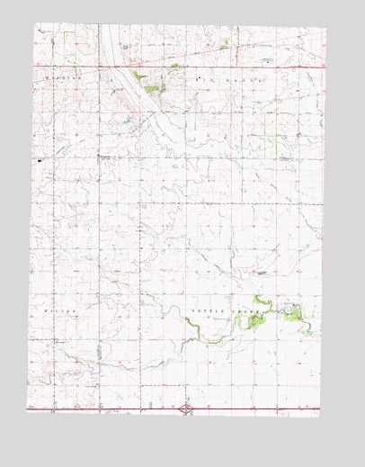
Stavanger, IL USGS Topographic Map
Click on map above to begin viewing in our Map Viewer.

This topographic map contains these locations and features:
Feature Name Type Latitude Longitude GNIS ID View Map
Apakeska Grove (historical)WoodsN41.4961°W88.5456°1808691View Map
Brown School (historical)SchoolN41.4428°W88.5442°1720471View Map
Cassem School (historical)SchoolN41.4284°W88.5098°1720473View Map
Collins Grove (historical)WoodsN41.4850°W88.5620°1808702View Map
Dix School (historical)SchoolN41.4286°W88.5784°1720477View Map
Forbes School (historical)SchoolN41.3770°W88.6092°1748220View Map
Gray School (historical)SchoolN41.4064°W88.5778°1720483View Map
Hoge School (historical)SchoolN41.3920°W88.5184°1720490View Map
Holderman and Hoge CemeteryCemeteryN41.4059°W88.5387°410381View Map
Holdermans Grove (historical)WoodsN41.4717°W88.5876°1808712View Map
Interchange 105CrossingN41.3773°W88.5573°1808671View Map
Kelloggs GroveWoodsN41.4795°W88.5745°1808714View Map
Long Point CreekStreamN41.3750°W88.5812°412590View Map
Morey School (historical)SchoolN41.3845°W88.5770°1721115View Map
Mount Pleasant School (historical)SchoolN41.4717°W88.6154°1748250View Map
Naden School (historical)SchoolN41.4948°W88.5381°1720242View Map
Ness School (historical)SchoolN41.4436°W88.5106°1721117View Map
Nettle CreekPopulated PlaceN41.4425°W88.5781°423014View Map
Nettle Creek Elementary SchoolSchoolN41.4109°W88.5120°414369View Map
Nettle Creek LandingsAirportN41.4300°W88.5247°2770499View Map
Sampson School (historical)SchoolN41.4386°W88.6154°1748261View Map
Scott School (historical)SchoolN41.4720°W88.5117°1720243View Map
StavangerPopulated PlaceN41.3986°W88.6140°419078View Map
Stavanger Lutheran CemeteryCemeteryN41.3839°W88.5948°419079View Map
Stavanger Lutheran ChurchChurchN41.3984°W88.6123°1986437View Map
Stephens School (historical)SchoolN41.4723°W88.5692°1720245View Map
Township of Nettle CreekCivilN41.4139°W88.5378°429427View Map
Vogen RLA AirportAirportN41.4616°W88.5942°427600View Map
West Lisbon Lutheran CemeteryCemeteryN41.4772°W88.5347°1808681View Map
West Lisbon Lutheran ChurchChurchN41.4759°W88.5284°412263View Map

Note: Coordinates in the location and feature list above are referenced to NAD83 datum.


Copyright (C) 2008-2024 Ryan Niemi / Sunset Dynamics ... All Rights Reserved