TopoQuest Logo
Do you find TopoQuest useful?
Help keep TopoQuest running and adding new maps/features by donating!
Bitcoin:  19c7KJd3qBynnjoSw5npx9KScwjBe4ifkT
Litecoin:  LXs6TkuXGGXo1vDsWCkWVdjQX94eUKd6ui
Home View Maps Find Maps Find Places Resources & Links


Sheridan, Illinois Topographic Map

USGS Map Title: Sheridan, IL
USGS Map MRC: 41088E6
DRG (GeoTIFF) Download: o41088e6.tif


Neighboring USGS Topographic Map Quads:


  Shabbona Grove, IL  
41088F7
 

  Somonauk, IL  
41088F6
 

  Plano, IL  
41088F5
 

  Leland, IL  
41088E7
 

  Sheridan, IL  
41088E6
 

  Newark, IL  
41088E5
 

  Wedron, IL  
41088D7
 

  Serena, IL  
41088D6
 

  Stavanger, IL  
41088D5


Map MRC Location:

N42°
W89°
N42°
W88°
H8 H7 H6 H5 H4 H3 H2 H1
G8 G7 G6 G5 G4 G3 G2 G1
F8 F7 F6 F5 F4 F3 F2 F1
E8 E7 E6 E5 E4 E3 E2 E1
D8 D7 D6 D5 D4 D3 D2 D1
C8 C7 C6 C5 C4 C3 C2 C1
B8 B7 B6 B5 B4 B3 B2 B1
A8 A7 A6 A5 A4 A3 A2 A1
N41°
W89°
N41°
W88°

Sheridan, IL USGS 1:24K Topographic Map Preview:
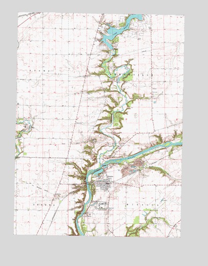
Sheridan, IL USGS Topographic Map
Click on map above to begin viewing in our Map Viewer.

This topographic map contains these locations and features:
Feature Name Type Latitude Longitude GNIS ID View Map
Baker School (historical)SchoolN41.5845°W88.7004°1718845View Map
Bowers PitMineN41.5259°W88.6912°1998808View Map
Breuer School (historical)SchoolN41.5853°W88.6495°1718841View Map
Bronson School (historical)SchoolN41.5703°W88.7304°1718848View Map
CatharinePopulated PlaceN41.5231°W88.7192°405700View Map
Century Acres Dairy FarmLocaleN41.5356°W88.6569°2628333View Map
Coultrip School (historical)SchoolN41.6023°W88.7306°1718847View Map
Cwian FieldAirportN41.5430°W88.6881°427806View Map
Dreischmeir School (historical)SchoolN41.6178°W88.6509°1718842View Map
Elerding CemeteryCemeteryN41.5453°W88.6767°407856View Map
Family Church of the NazareneChurchN41.5289°W88.6829°1986434View Map
French Church (historical)ChurchN41.5286°W88.7287°1718850View Map
Glen ParkParkN41.5314°W88.7020°1748226View Map
Harrington Farms Airport (historical)AirportN41.5576°W88.6618°427807View Map
Hobbs School (historical)SchoolN41.5284°W88.7162°1718851View Map
Johnson AirportAirportN41.6074°W88.6632°427789View Map
Lake HolidayReservoirN41.6167°W88.6706°410388View Map
Lake HolidayPopulated PlaceN41.6129°W88.6721°2629891View Map
Lake Holiday Census Designated PlaceCensusN41.6156°W88.6703°2629851View Map
Lake Holiday DamDamN41.6054°W88.6784°1691526View Map
Lett CemeteryCemeteryN41.5820°W88.6478°411957View Map
Neff School (historical)SchoolN41.5009°W88.6342°1718839View Map
NorthvillePopulated PlaceN41.5634°W88.7054°414702View Map
Northville CemeteryCemeteryN41.5806°W88.6978°414703View Map
Pooler School (historical)SchoolN41.5039°W88.6795°1718846View Map
Roods CreekStreamN41.5436°W88.6665°416908View Map
Saint John Catholic CemeteryCemeteryN41.6170°W88.6865°1718843View Map
Saint John Lutheran CemeteryCemeteryN41.6109°W88.6917°417383View Map
Seaman CemeteryCemeteryN41.5542°W88.6926°418162View Map
Seventh Day Adventist ChurchChurchN41.5295°W88.6817°1986435View Map
SheridanPopulated PlaceN41.5300°W88.6798°418353View Map
Sheridan CemeteryCemeteryN41.5303°W88.6762°1957999View Map
Sheridan Correctional CenterBuildingN41.5161°W88.6842°410766View Map
Sheridan Elementary SchoolSchoolN41.5298°W88.6798°1816142View Map
Sheridan Fire Protection DistrictBuildingN41.5305°W88.6804°2681734View Map
Sheridan Police DepartmentBuildingN41.5305°W88.6803°2756975View Map
Sheridan Post OfficePost OfficeN41.5301°W88.6811°2788191View Map
Sheridan United Methodist ChurchChurchN41.5284°W88.6817°1986436View Map
Sly School (historical)SchoolN41.5589°W88.6570°1718840View Map
Somonauk CreekStreamN41.5398°W88.6856°422085View Map
Suppes School (historical)SchoolN41.6092°W88.6931°1718844View Map
Township of MissionCivilN41.5030°W88.6442°429375View Map
Township of NorthvilleCivilN41.5881°W88.6595°429465View Map
Troup QuarryMineN41.5117°W88.6973°1986093View Map
Union School (historical)SchoolN41.5439°W88.7479°1718849View Map
Village of SheridanCivilN41.5285°W88.6790°2399800View Map
Walnut Creek AirportAirportN41.5953°W88.6948°427815View Map
Whitehead CemeteryCemeteryN41.5156°W88.6806°421091View Map

Note: Coordinates in the location and feature list above are referenced to NAD83 datum.


Copyright (C) 2008-2024 Ryan Niemi / Sunset Dynamics ... All Rights Reserved