TopoQuest Logo
Do you find TopoQuest useful?
Help keep TopoQuest running and adding new maps/features by donating!
Bitcoin:  19c7KJd3qBynnjoSw5npx9KScwjBe4ifkT
Litecoin:  LXs6TkuXGGXo1vDsWCkWVdjQX94eUKd6ui
Home View Maps Find Maps Find Places Resources & Links


Okete, Missouri Topographic Map

USGS Map Title: Okete, MO
USGS Map MRC: 39090A8
DRG (GeoTIFF) Download: o39090a8.tif


Neighboring USGS Topographic Map Quads:


  Eolia, MO  
39091B1
 

  Auburn, MO  
39090B8
 

  Elsberry, MO  
39090B7
 

  Silex, MO  
39091A1
 

  Okete, MO  
39090A8
 

  Luckett Ridge, MO  
39090A7
 

  Warrenton NE, MO  
38091H1
 

  Troy, MO  
38090H8
 

  Maryknoll, MO  
38090H7


Map MRC Location:

N40°
W91°
N40°
W90°
H8 H7 H6 H5 H4 H3 H2 H1
G8 G7 G6 G5 G4 G3 G2 G1
F8 F7 F6 F5 F4 F3 F2 F1
E8 E7 E6 E5 E4 E3 E2 E1
D8 D7 D6 D5 D4 D3 D2 D1
C8 C7 C6 C5 C4 C3 C2 C1
B8 B7 B6 B5 B4 B3 B2 B1
A8 A7 A6 A5 A4 A3 A2 A1
N39°
W91°
N39°
W90°

Okete, MO USGS 1:24K Topographic Map Preview:
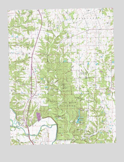
Okete, MO USGS Topographic Map
Click on map above to begin viewing in our Map Viewer.

This topographic map contains these locations and features:
Feature Name Type Latitude Longitude GNIS ID View Map
Alexander CemeteryCemeteryN39.0334°W90.8897°713200View Map
Alexandria Church (historical)ChurchN39.0431°W90.9737°742455View Map
Bailey BranchStreamN39.0452°W90.8782°713540View Map
Bricker CemeteryCemeteryN39.0514°W90.9985°714688View Map
BrussellsPopulated PlaceN39.0509°W90.8790°740701View Map
Camp AveryLocaleN39.0187°W90.9151°715239View Map
Camp CuivreLocaleN39.0125°W90.9187°715262View Map
Camp DerricoteLocaleN39.0553°W90.9379°715263View Map
Camp Frenchmans BluffLocaleN39.0314°W90.9496°735456View Map
Camp Sherwood ForestLocaleN39.0423°W90.9143°715288View Map
Camp TuckahoLocaleN39.0498°W90.9521°715293View Map
Carter Hall School (historical)SchoolN39.0386°W90.9686°742647View Map
Christofferson Lake DamDamN39.0750°W90.9101°760539View Map
Cochran CemeteryCemeteryN39.1220°W90.9749°716057View Map
Cuivre HeightsPopulated PlaceN39.0292°W90.9929°735391View Map
Cuivre River State ParkParkN39.0337°W90.9310°735571View Map
David Kessler Memorial State Wildlife AreaParkN39.0648°W90.9121°716690View Map
Davis CemeteryCemeteryN39.1151°W90.8912°2585127View Map
Dodson CemeteryCemeteryN39.0610°W90.9074°716942View Map
Dowell School (historical)SchoolN39.0550°W90.9860°742454View Map
Downing CemeteryCemeteryN39.1112°W90.8832°717034View Map
Draper BranchStreamN39.1103°W90.9862°717047View Map
Dry BranchStreamN39.0191°W90.9291°717071View Map
Emert LakeReservoirN39.0741°W90.9060°761598View Map
Emert Lake DamDamN39.0734°W90.9068°761597View Map
First United ChurchChurchN39.0231°W90.9838°717934View Map
Frenchmans BluffCliffN39.0250°W90.9415°718218View Map
Girl Scout LakeReservoirN39.0534°W90.9535°761992View Map
Girl Scout Lake DamDamN39.0534°W90.9535°761991View Map
Girl Scouts DamDamN39.0584°W90.9568°761599View Map
Gladney CemeteryCemeteryN39.1206°W90.9296°718484View Map
Hamilton CemeteryCemeteryN39.1231°W90.9057°719031View Map
Harmony Grove CemeteryCemeteryN39.0731°W90.9160°719119View Map
Harmony Grove School (historical)SchoolN39.0728°W90.9152°742453View Map
Hill School (historical)SchoolN39.0225°W90.9112°742456View Map
Holiness ChurchChurchN39.0842°W90.9821°719706View Map
Hopkins CemeteryCemeteryN39.0607°W90.9076°719818View Map
Indian Nest HollowStreamN39.0567°W90.9476°735390View Map
Lake LincolnReservoirN39.0190°W90.9177°721095View Map
Lake Lincoln DamDamN39.0200°W90.9218°760541View Map
Lincoln CountyCivilN39.0580°W90.9600°758511View Map
Lincoln County Fire Protection District 1 Station 3BuildingN39.0507°W90.8974°2620828View Map
Lincoln County Fire Protection District 1 Station 4BuildingN39.0455°W90.9732°2620827View Map
Morris CemeteryCemeteryN39.0842°W90.9765°722642View Map
Morris School (historical)SchoolN39.0839°W90.9821°742452View Map
North Fork Cuivre RiverStreamN39.0170°W90.9926°729582View Map
OketePopulated PlaceN39.0978°W90.9304°723707View Map
Old Alexandria CemeteryCemeteryN39.0466°W90.9717°2582613View Map
Old Alexandria ChurchChurchN39.0467°W90.9715°723711View Map
Old Morris CemeteryCemeteryN39.0812°W90.9765°723767View Map
Porter SloughStreamN39.0156°W90.9904°724768View Map
Reid CemeteryCemeteryN39.0913°W90.9240°725207View Map
Reid School (historical)SchoolN39.1131°W90.9218°742451View Map
Riggs Ford (historical)LocaleN39.0098°W90.9785°735392View Map
Shady Eighty Ranch LakeReservoirN39.0767°W90.9334°761994View Map
Shady Eighty Ranch Lake DamDamN39.0767°W90.9351°761993View Map
Sherwood ForestAreaN39.0417°W90.9168°735393View Map
Spring CreekStreamN39.0095°W90.9815°726907View Map
Sugar Creek Church (historical)ChurchN39.0037°W90.9315°742457View Map
Suter LakeReservoirN39.0664°W90.8909°761942View Map
Suter Lake DamDamN39.0650°W90.8901°761941View Map
Thornhill CemeteryCemeteryN39.0028°W90.9265°727615View Map
Township of Snow HillCivilN39.0544°W90.8970°766909View Map
Welker LakeReservoirN39.0750°W90.9101°760540View Map
West Fork Cuivre RiverStreamN39.0170°W90.9926°728560View Map
Whiteside CemeteryCemeteryN39.1162°W90.8796°728788View Map

Note: Coordinates in the location and feature list above are referenced to NAD83 datum.


Copyright (C) 2008-2024 Ryan Niemi / Sunset Dynamics ... All Rights Reserved