TopoQuest Logo
Do you find TopoQuest useful?
Help keep TopoQuest running and adding new maps/features by donating!
Bitcoin:  19c7KJd3qBynnjoSw5npx9KScwjBe4ifkT
Litecoin:  LXs6TkuXGGXo1vDsWCkWVdjQX94eUKd6ui
Home View Maps Find Maps Find Places Resources & Links


Silex, Missouri Topographic Map

USGS Map Title: Silex, MO
USGS Map MRC: 39091A1
DRG (GeoTIFF) Download: o39091a1.tif


Neighboring USGS Topographic Map Quads:


  Louisville, MO  
39091B2
 

  Eolia, MO  
39091B1
 

  Auburn, MO  
39090B8
 

  Truxton, MO  
39091A2
 

  Silex, MO  
39091A1
 

  Okete, MO  
39090A8
 

  Hawk Point, MO  
38091H2
 

  Warrenton NE, MO  
38091H1
 

  Troy, MO  
38090H8


Map MRC Location:

N40°
W92°
N40°
W91°
H8 H7 H6 H5 H4 H3 H2 H1
G8 G7 G6 G5 G4 G3 G2 G1
F8 F7 F6 F5 F4 F3 F2 F1
E8 E7 E6 E5 E4 E3 E2 E1
D8 D7 D6 D5 D4 D3 D2 D1
C8 C7 C6 C5 C4 C3 C2 C1
B8 B7 B6 B5 B4 B3 B2 B1
A8 A7 A6 A5 A4 A3 A2 A1
N39°
W92°
N39°
W91°

Silex, MO USGS 1:24K Topographic Map Preview:
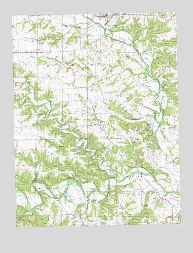
Silex, MO USGS Topographic Map
Click on map above to begin viewing in our Map Viewer.

This topographic map contains these locations and features:
Feature Name Type Latitude Longitude GNIS ID View Map
Baldwin AirportAirportN39.1142°W91.0448°758970View Map
Barnable School (historical)SchoolN39.0694°W91.0954°742425View Map
Big Lead CreekStreamN39.0759°W91.1096°714190View Map
Bohmer School (historical)SchoolN39.0317°W91.0176°742427View Map
BriscoePopulated PlaceN39.0820°W91.0121°714714View Map
Briscoe CemeteryCemeteryN39.0867°W91.0112°714716View Map
Burkemper LakeReservoirN39.0022°W91.0200°761972View Map
Burkemper Lake DamDamN39.0017°W91.0185°761971View Map
CavePopulated PlaceN39.0198°W91.0435°1669590View Map
Clary CemeteryCemeteryN39.0911°W91.0515°715898View Map
Cottonwood BranchStreamN39.0173°W91.0704°716353View Map
Cox CemeteryCemeteryN39.1170°W91.0437°716425View Map
DavisPopulated PlaceN39.0581°W91.0196°716697View Map
Dry BranchStreamN39.0211°W91.0623°717077View Map
Elliot School (historical)SchoolN39.0014°W91.0260°742429View Map
FamousPopulated PlaceN39.0350°W91.0121°740609View Map
Famous Post Office (historical)Post OfficeN39.0350°W91.0121°760127View Map
Forest Gem School (historical)SchoolN39.0898°W91.0535°742424View Map
Fort BranchStreamN39.1009°W91.0288°718107View Map
Guthrie CemeteryCemeteryN39.0012°W91.0149°718946View Map
Helps BranchStreamN39.0931°W91.0218°719356View Map
Henebry LakeReservoirN39.0096°W91.1057°761970View Map
Henebry Lake DamDamN39.0100°W91.1068°761969View Map
Howell CemeteryCemeteryN39.0049°W91.0396°719930View Map
Hunter CemeteryCemeteryN39.0142°W91.0671°720012View Map
Hupp BranchStreamN39.0589°W91.0135°720027View Map
Keithey School (historical)SchoolN39.0073°W91.0529°735378View Map
Kinion CemeteryCemeteryN39.0595°W91.0610°720633View Map
Lead CreekStreamN39.0277°W91.0497°720860View Map
Little Lead CreekStreamN39.0759°W91.1099°721262View Map
MackvillePopulated PlaceN39.0592°W91.0601°740557View Map
Mackville Post Office (historical)Post OfficeN39.0592°W91.0601°760136View Map
Mashek (historical)Populated PlaceN39.0042°W91.0760°740149View Map
Mashek Church (historical)ChurchN39.0045°W91.0749°742430View Map
Mill CreekStreamN39.1156°W91.0546°722335View Map
MillwoodPopulated PlaceN39.1028°W91.1063°735726View Map
Millwood School (historical)SchoolN39.1042°W91.1068°735379View Map
Mumford CemeteryCemeteryN39.0156°W91.0179°723062View Map
Nulls CreekStreamN39.0887°W91.0224°735755View Map
Owen School (historical)SchoolN39.0525°W91.0418°742426View Map
Paris BranchStreamN39.0539°W91.0188°724008View Map
Peasel BranchStreamN39.0475°W91.0782°724153View Map
Saint Alphonsus CemeteryCemeteryN39.1081°W91.1054°725719View Map
Saint Alphonsus ParishChurchN39.1050°W91.1067°735386View Map
Saint Marys CemeteryCemeteryN39.0045°W91.0762°725835View Map
SilexPopulated PlaceN39.1234°W91.0543°726439View Map
Sitton BranchStreamN39.1206°W91.0638°726493View Map
Sitton CemeteryCemeteryN39.1173°W91.0771°726494View Map
Sitton SpringSpringN39.1175°W91.0783°735855View Map
Spring Creek Community CenterLocaleN39.0281°W91.0290°726911View Map
Steffen BridgeBridgeN39.0300°W91.0288°742428View Map
Stepanek CrossingPopulated PlaceN39.0206°W91.0654°741287View Map
Sulphur Lick CemeteryCemeteryN39.0611°W91.0604°727273View Map
Terbrock LakeReservoirN39.0171°W91.0868°761567View Map
Terbrock Lake DamDamN39.0167°W91.0868°761566View Map
Town of CaveCivilN39.0214°W91.0483°2396631View Map
Township of BedfordCivilN39.0030°W91.0070°766900View Map
Township of MillwoodCivilN39.0907°W91.0968°766905View Map
Trail CemeteryCemeteryN39.0581°W91.0565°727755View Map
Troy AirparkAirportN39.0465°W91.0259°2679388View Map
Turkey CreekStreamN39.0095°W91.1132°727858View Map
Wommacks FordLocaleN39.1003°W91.0293°735380View Map

Note: Coordinates in the location and feature list above are referenced to NAD83 datum.


Copyright (C) 2008-2024 Ryan Niemi / Sunset Dynamics ... All Rights Reserved