TopoQuest Logo
Do you find TopoQuest useful?
Help keep TopoQuest running and adding new maps/features by donating!
Bitcoin:  19c7KJd3qBynnjoSw5npx9KScwjBe4ifkT
Litecoin:  LXs6TkuXGGXo1vDsWCkWVdjQX94eUKd6ui
Home View Maps Find Maps Find Places Resources & Links


Warrenton NE, Missouri Topographic Map

USGS Map Title: Warrenton NE, MO
USGS Map MRC: 38091H1
DRG (GeoTIFF) Download: o38091h1.tif


Neighboring USGS Topographic Map Quads:


  Truxton, MO  
39091A2
 

  Silex, MO  
39091A1
 

  Okete, MO  
39090A8
 

  Hawk Point, MO  
38091H2
 

  Warrenton NE, MO  
38091H1
 

  Troy, MO  
38090H8
 

  Warrenton, MO  
38091G2
 

  Wright City, MO  
38091G1
 

  Foristell, MO  
38090G8


Map MRC Location:

N39°
W92°
N39°
W91°
H8 H7 H6 H5 H4 H3 H2 H1
G8 G7 G6 G5 G4 G3 G2 G1
F8 F7 F6 F5 F4 F3 F2 F1
E8 E7 E6 E5 E4 E3 E2 E1
D8 D7 D6 D5 D4 D3 D2 D1
C8 C7 C6 C5 C4 C3 C2 C1
B8 B7 B6 B5 B4 B3 B2 B1
A8 A7 A6 A5 A4 A3 A2 A1
N38°
W92°
N38°
W91°

Warrenton NE, MO USGS 1:24K Topographic Map Preview:
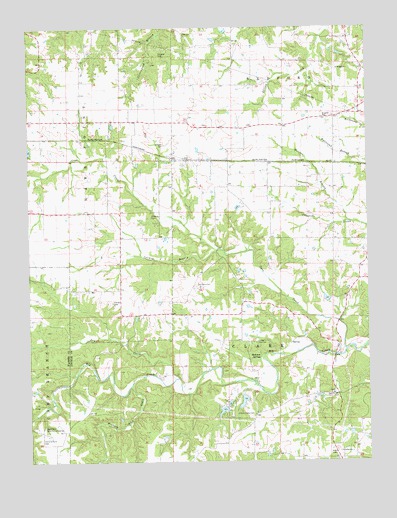
Warrenton NE, MO USGS Topographic Map
Click on map above to begin viewing in our Map Viewer.

This topographic map contains these locations and features:
Feature Name Type Latitude Longitude GNIS ID View Map
Becker LakeReservoirN38.8923°W91.0464°761614View Map
Becker Lake DamDamN38.8950°W91.0468°761613View Map
Big Creek Community CenterLocaleN38.8850°W91.1199°714162View Map
Boone Elementary SchoolSchoolN38.9739°W91.0056°2651587View Map
Brown School (historical)SchoolN38.9959°W91.0938°747916View Map
Camp Char-renLocaleN38.9092°W91.0415°715256View Map
Camp Ground CemeteryCemeteryN38.8823°W91.1204°715268View Map
Camp Ground Church (historical)ChurchN38.8842°W91.1218°747918View Map
Camp Ground School (historical)SchoolN38.8842°W91.1226°730322View Map
Casmer BranchStreamN38.9356°W91.0551°715474View Map
Casselman BranchStreamN38.9231°W91.0324°735420View Map
Coon CreekStreamN38.9070°W91.0085°716255View Map
Crystal LakeReservoirN38.8897°W91.0539°761621View Map
Crystal Lake DamDamN38.8900°W91.0535°761620View Map
Douglas CemeteryCemeteryN38.9920°W91.0765°717007View Map
Dry CreekStreamN38.8989°W91.0715°731564View Map
East CemeteryCemeteryN38.9723°W91.0588°2585140View Map
Genteman LakeReservoirN38.9218°W91.0154°761536View Map
Genteman Lake DamDamN38.9217°W91.0151°761535View Map
Hammond School (historical)SchoolN38.9367°W91.0429°735419View Map
Harvey CemeteryCemeteryN38.9209°W91.0943°719190View Map
Hedemen SpringsSpringN38.9053°W91.0396°719337View Map
Hickory Lick CreekStreamN38.8973°W91.0879°731582View Map
Indian Camp CemeteryCemeteryN38.8888°W91.0428°720103View Map
Koelling School (historical)SchoolN38.8870°W91.0429°747921View Map
Lincoln Elementary SchoolSchoolN38.9744°W91.0066°2651588View Map
Linns Mills (historical)Populated PlaceN38.9448°W91.0560°740154View Map
Meister BranchStreamN38.9437°W91.0065°722204View Map
Mononame 345 DamDamN38.8834°W91.0501°761419View Map
Monroe FieldAirportN38.9651°W91.1192°2679341View Map
Moore School (historical)SchoolN38.9720°W91.0304°747919View Map
Old Davis CemeteryCemeteryN38.9264°W91.0637°723746View Map
Perkins School (historical)SchoolN38.9717°W91.0540°735418View Map
Schroer School (historical)SchoolN38.9181°W91.0729°747920View Map
Schupmann LakeReservoirN38.9550°W91.0651°761601View Map
Schupmann Lake DamDamN38.9550°W91.0651°761600View Map
Shelton CemeteryCemeteryN38.9456°W91.0799°726318View Map
Shelton School (historical)SchoolN38.9620°W91.0904°747917View Map
Slavens CemeteryCemeteryN38.9667°W91.0749°726539View Map
Township of Hawk PointCivilN38.9821°W91.1219°766903View Map
WoodlakeReservoirN38.9250°W91.0118°761796View Map
Woodlake DamDamN38.9250°W91.0118°761795View Map
Woodland AirstripAirportN38.9119°W91.0372°2679397View Map
Wright City Fire Protection District Station 3BuildingN38.8762°W91.0112°2621287View Map
Zoar ChurchChurchN38.8945°W91.0132°735932View Map

Note: Coordinates in the location and feature list above are referenced to NAD83 datum.


Copyright (C) 2008-2024 Ryan Niemi / Sunset Dynamics ... All Rights Reserved