TopoQuest Logo
Do you find TopoQuest useful?
Help keep TopoQuest running and adding new maps/features by donating!
Bitcoin:  19c7KJd3qBynnjoSw5npx9KScwjBe4ifkT
Litecoin:  LXs6TkuXGGXo1vDsWCkWVdjQX94eUKd6ui
Home View Maps Find Maps Find Places Resources & Links


Omro, Wisconsin Topographic Map

USGS Map Title: Omro, WI
USGS Map MRC: 44088A6
DRG (GeoTIFF) Download: o44088a6.tif


Neighboring USGS Topographic Map Quads:


  Lake Poygan, WI  
44088B7
 

  Oshkosh NW, WI  
44088B6
 

  Oshkosh NE, WI  
44088B5
 

  Eureka, WI  
44088A7
 

  Omro, WI  
44088A6
 

  Oshkosh, WI  
44088A5
 

  Rush Lake, WI  
43088H7
 

  Pickett, WI  
43088H6
 

  Van Dyne, WI  
43088H5


Map MRC Location:

N45°
W89°
N45°
W88°
H8 H7 H6 H5 H4 H3 H2 H1
G8 G7 G6 G5 G4 G3 G2 G1
F8 F7 F6 F5 F4 F3 F2 F1
E8 E7 E6 E5 E4 E3 E2 E1
D8 D7 D6 D5 D4 D3 D2 D1
C8 C7 C6 C5 C4 C3 C2 C1
B8 B7 B6 B5 B4 B3 B2 B1
A8 A7 A6 A5 A4 A3 A2 A1
N44°
W89°
N44°
W88°

Omro, WI USGS 1:24K Topographic Map Preview:
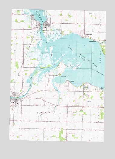
Omro, WI USGS Topographic Map
Click on map above to begin viewing in our Map Viewer.

This topographic map contains these locations and features:
Feature Name Type Latitude Longitude GNIS ID View Map
Beiser FarmLocaleN44.1108°W88.6653°2711722View Map
Butte des MortsPopulated PlaceN44.0994°W88.6540°1562472View Map
Butte des Morts Census Designated PlaceCensusN44.1059°W88.6566°2586462View Map
Butte Des Morts Post OfficePost OfficeN44.1000°W88.6542°2711688View Map
Carter Memorial LibraryBuildingN44.0386°W88.7376°1843496View Map
City of OmroCivilN44.0391°W88.7379°1583859View Map
Courtney Plummer AirportAirportN44.1069°W88.6840°1582274View Map
Daggets CreekStreamN44.0933°W88.6332°1563657View Map
Deja Vu FarmLocaleN44.0058°W88.7031°2629053View Map
First Baptist ChurchChurchN44.0355°W88.7462°1843522View Map
First Presbyterian ChurchChurchN44.0369°W88.7446°1843530View Map
Grace Lutheran ChurchChurchN44.0372°W88.7446°1843549View Map
Grand Butte Des MortsCliffN44.0989°W88.6523°1851622View Map
Gunz FarmsLocaleN44.0106°W88.6550°2711657View Map
Harbor SpringsPopulated PlaceN44.0641°W88.6857°1577628View Map
Highland ShorePopulated PlaceN44.0508°W88.6307°1566400View Map
Lake Butte des MortsLakeN44.0701°W88.6388°1562474View Map
Mill AcresLocaleN44.0122°W88.6311°2711646View Map
Nichols Shore AcresPopulated PlaceN44.0972°W88.6398°1570283View Map
Nickels MarshSwampN44.0841°W88.6971°1570285View Map
OmroPopulated PlaceN44.0394°W88.7443°1570814View Map
Omro Elementary SchoolSchoolN44.0502°W88.7437°2716788View Map
Omro High SchoolSchoolN44.0464°W88.7389°1843599View Map
Omro Junction CemeteryCemeteryN44.0339°W88.6637°1570816View Map
Omro Junction Elementary SchoolSchoolN44.0336°W88.6537°1575913View Map
Omro Methodist Episcopal Church (historical)ChurchN44.0358°W88.7446°1843600View Map
Omro Middle SchoolSchoolN44.0462°W88.7408°2716485View Map
Omro Police DepartmentBuildingN44.0384°W88.7450°2759452View Map
Omro Post OfficePost OfficeN44.0394°W88.7440°1843601View Map
Omro Rushford Volunteer Fire DepartmentBuildingN44.0382°W88.7495°2697695View Map
Omro Union CemeteryCemeteryN44.0336°W88.6629°1570817View Map
Omro Wastewater Treatment PlantLocaleN44.0456°W88.7314°2711683View Map
Oshkosh Sky Ranch Airport (historical)AirportN44.0155°W88.7108°2444165View Map
Overton FarmLocaleN44.0958°W88.6306°2711694View Map
Patch Elementary SchoolSchoolN44.0351°W88.7403°1843622View Map
Pingry SchoolSchoolN44.0766°W88.7337°1571535View Map
Plummer PointPopulated PlaceN44.0875°W88.6293°1571707View Map
Quigleys PointCapeN44.0964°W88.7096°1572002View Map
Rasmussen's Apple AcresLocaleN44.0300°W88.6289°2631608View Map
ReighmoorPopulated PlaceN44.0575°W88.6737°1572191View Map
Remer FarmsLocaleN44.0067°W88.7308°2629052View Map
RivermoorPopulated PlaceN44.0728°W88.6862°1572354View Map
Saint Lukes Evangelical Lutheran ChurchChurchN44.0383°W88.7473°1843647View Map
Saint Marys Roman Catholic ChurchChurchN44.0336°W88.7421°1843652View Map
Schmude FarmsLocaleN44.0928°W88.7356°2711731View Map
Sheppard QuarryMineN44.0431°W88.6258°2634488View Map
Sky Diving AirportAirportN44.0396°W88.7014°1582124View Map
Sleepy Hollow FarmLocaleN44.0797°W88.7350°2711730View Map
Spring BrookStreamN44.0572°W88.6934°1574598View Map
Terrell IslandIslandN44.0716°W88.6632°1575316View Map
Tidy View DairyLocaleN44.0317°W88.7069°2711732View Map
Town CemeteryCemeteryN44.1130°W88.7179°1964388View Map
Town of OmroCivilN44.0278°W88.7050°1583860View Map
Town of WinneconneCivilN44.0836°W88.7042°1584458View Map
Village of WinneconneCivilN44.1118°W88.7108°1584457View Map
Wilzville FarmsLocaleN44.0519°W88.6847°2711728View Map
Winchester Elementary SchoolSchoolN44.1082°W88.7047°2716189View Map
Winnebago CountyCivilN44.0689°W88.6447°1581129View Map
WinneconnePopulated PlaceN44.1108°W88.7126°1576880View Map
Winneconne - Poygan Fire DistrictBuildingN44.1115°W88.7189°2697595View Map
Winneconne CemeteryCemeteryN44.1058°W88.7054°1964389View Map
Winneconne Elementary SchoolSchoolN44.1083°W88.7050°2716583View Map
Winneconne High SchoolSchoolN44.1198°W88.6965°1843707View Map
Winneconne Middle SchoolSchoolN44.1182°W88.6962°2716896View Map
Winneconne Police DepartmentBuildingN44.1102°W88.7129°2759400View Map
Winneconne Post OfficePost OfficeN44.1103°W88.7139°2711689View Map
Winneconne Public LibraryBuildingN44.1100°W88.7131°2711690View Map
Winneconne Wastewater Treatment PlantLocaleN44.1044°W88.7158°2711685View Map
Wolf RiverStreamN44.0925°W88.6926°1580823View Map

Note: Coordinates in the location and feature list above are referenced to NAD83 datum.


Copyright (C) 2008-2024 Ryan Niemi / Sunset Dynamics ... All Rights Reserved