TopoQuest Logo
Do you find TopoQuest useful?
Help keep TopoQuest running and adding new maps/features by donating!
Bitcoin:  19c7KJd3qBynnjoSw5npx9KScwjBe4ifkT
Litecoin:  LXs6TkuXGGXo1vDsWCkWVdjQX94eUKd6ui
Home View Maps Find Maps Find Places Resources & Links


Eureka, Wisconsin Topographic Map

USGS Map Title: Eureka, WI
USGS Map MRC: 44088A7
DRG (GeoTIFF) Download: o44088a7.tif


Neighboring USGS Topographic Map Quads:


  Poy Sippi, WI  
44088B8
 

  Lake Poygan, WI  
44088B7
 

  Oshkosh NW, WI  
44088B6
 

  Auroraville, WI  
44088A8
 

  Eureka, WI  
44088A7
 

  Omro, WI  
44088A6
 

  Berlin, WI  
43088H8
 

  Rush Lake, WI  
43088H7
 

  Pickett, WI  
43088H6


Map MRC Location:

N45°
W89°
N45°
W88°
H8 H7 H6 H5 H4 H3 H2 H1
G8 G7 G6 G5 G4 G3 G2 G1
F8 F7 F6 F5 F4 F3 F2 F1
E8 E7 E6 E5 E4 E3 E2 E1
D8 D7 D6 D5 D4 D3 D2 D1
C8 C7 C6 C5 C4 C3 C2 C1
B8 B7 B6 B5 B4 B3 B2 B1
A8 A7 A6 A5 A4 A3 A2 A1
N44°
W89°
N44°
W88°

Eureka, WI USGS 1:24K Topographic Map Preview:
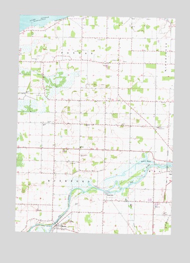
Eureka, WI USGS Topographic Map
Click on map above to begin viewing in our Map Viewer.

This topographic map contains these locations and features:
Feature Name Type Latitude Longitude GNIS ID View Map
Burdick CemeteryCemeteryN44.0636°W88.8509°1562417View Map
Cattleleana RanchLocaleN44.0778°W88.7836°2711733View Map
Edinger Field (historical)AirportN44.0047°W88.8709°1581971View Map
Enterprise Special Education SchoolSchoolN44.0624°W88.8190°1564679View Map
EurekaPopulated PlaceN44.0044°W88.8418°1564708View Map
Eureka Census Designated PlaceCensusN44.0073°W88.8426°2586486View Map
Forest Grove CemeteryCemeteryN44.0986°W88.8609°1565116View Map
Foust FarmsLocaleN44.0608°W88.7678°2711725View Map
Goggins CemeteryCemeteryN44.0619°W88.7640°1565601View Map
Happy Jacks Air StripAirportN44.0012°W88.8311°1581970View Map
Hogers BayouBayN44.0425°W88.7707°1566526View Map
Island ParkPopulated PlaceN44.0228°W88.8023°1567042View Map
Kafer FarmsLocaleN44.0122°W88.8472°2711727View Map
Knigge FarmsLocaleN44.0581°W88.8069°2711726View Map
Liberty SchoolSchoolN44.0628°W88.8548°1568023View Map
Methodist ChurchChurchN44.0486°W88.8246°1569386View Map
North Rushford CemeteryCemeteryN44.0447°W88.8243°1570495View Map
Oak Hill CemeteryCemeteryN44.0772°W88.8015°1570647View Map
Omro CemeteryCemeteryN44.0216°W88.7554°1570815View Map
Saint Thomas CemeteryCemeteryN44.1005°W88.7954°1964387View Map
Saint Thomas ChurchChurchN44.1000°W88.7954°1573589View Map
Schuster FarmLocaleN44.0136°W88.8172°2711729View Map
Town of PoyganCivilN44.1125°W88.8254°1583968View Map
Town of RushfordCivilN44.0219°W88.8252°1584076View Map
Waukau CreekStreamN44.0255°W88.7890°1576310View Map
Windy Hills FarmLocaleN44.0511°W88.8164°2629051View Map

Note: Coordinates in the location and feature list above are referenced to NAD83 datum.


Copyright (C) 2008-2024 Ryan Niemi / Sunset Dynamics ... All Rights Reserved