TopoQuest Logo
Do you find TopoQuest useful?
Help keep TopoQuest running and adding new maps/features by donating!
Bitcoin:  19c7KJd3qBynnjoSw5npx9KScwjBe4ifkT
Litecoin:  LXs6TkuXGGXo1vDsWCkWVdjQX94eUKd6ui
Home View Maps Find Maps Find Places Resources & Links


Owen, Wisconsin Topographic Map

USGS Map Title: Owen, WI
USGS Map MRC: 44090H5
DRG (GeoTIFF) Download: o44090h5.tif


Neighboring USGS Topographic Map Quads:


  Lublin, WI  
45090A6
 

  Lublin SE, WI  
45090A5
 

  Medford SW, WI  
45090A4
 

  Lombard, WI  
44090H6
 

  Owen, WI  
44090H5
 

  Curtiss, WI  
44090H4
 

  Mead Lake East, WI  
44090G6
 

  Greenwood, WI  
44090G5
 

  Riplinger, WI  
44090G4


Map MRC Location:

N45°
W91°
N45°
W90°
H8 H7 H6 H5 H4 H3 H2 H1
G8 G7 G6 G5 G4 G3 G2 G1
F8 F7 F6 F5 F4 F3 F2 F1
E8 E7 E6 E5 E4 E3 E2 E1
D8 D7 D6 D5 D4 D3 D2 D1
C8 C7 C6 C5 C4 C3 C2 C1
B8 B7 B6 B5 B4 B3 B2 B1
A8 A7 A6 A5 A4 A3 A2 A1
N44°
W91°
N44°
W90°

Owen, WI USGS 1:24K Topographic Map Preview:
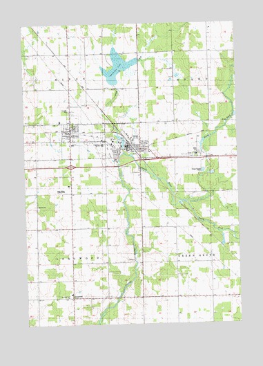
Owen, WI USGS Topographic Map
Click on map above to begin viewing in our Map Viewer.

This topographic map contains these locations and features:
Feature Name Type Latitude Longitude GNIS ID View Map
1 ReservoirReservoirN44.9683°W90.5118°1793288View Map
12 ReservoirReservoirN44.9750°W90.5718°1793562View Map
Brick CreekStreamN44.9466°W90.5668°1578858View Map
BrightPopulated PlaceN44.8861°W90.5321°1876583View Map
City of OwenCivilN44.9485°W90.5623°1583884View Map
Emanuel Lutheran CemeteryCemeteryN44.8866°W90.6021°1837656View Map
Emmanuel ChurchChurchN44.8866°W90.6012°1837657View Map
Hixon Heights SchoolSchoolN44.9877°W90.5760°1566489View Map
Hoard Center SchoolSchoolN44.9869°W90.5254°1566493View Map
Lloyd Kalepp 3WC77875a DamDamN44.9683°W90.5118°1793287View Map
LongwoodPopulated PlaceN44.8869°W90.5982°1568611View Map
Longwood CemeteryCemeteryN44.9250°W90.6196°1568612View Map
Moody School (historical)SchoolN44.9222°W90.5976°1876595View Map
Nazareth CemeteryCemeteryN44.9644°W90.5987°1570124View Map
North Bright School (historical)SchoolN44.9005°W90.5426°1876596View Map
North Fork Popple RiverStreamN44.9266°W90.5307°1570437View Map
OwenPopulated PlaceN44.9486°W90.5643°1577195View Map
Owen - Withee - Curtiss Fire Association / Owen - Withee Community Ambulance ServiceBuildingN44.9475°W90.5591°2698031View Map
Owen - Withee Elementary SchoolSchoolN44.9498°W90.5792°2715761View Map
Owen - Withee High SchoolSchoolN44.9499°W90.5792°1837707View Map
Owen - Withee Junior High SchoolSchoolN44.9498°W90.5792°2715727View Map
Owen City DamDamN44.9483°W90.5668°1791874View Map
Owen Police DepartmentBuildingN44.9493°W90.5630°2759558View Map
Owen Pond 5ReservoirN44.9521°W90.5688°1791875View Map
Owen-Withee AirportAirportN44.9495°W90.6016°1581056View Map
Poplar River Number 1 H-119 DamDamN44.9750°W90.5718°1793561View Map
Saint John ChurchChurchN44.9497°W90.5971°1837726View Map
South Bright School (historical)SchoolN44.8864°W90.5576°1876602View Map
South Fork Popple RiverStreamN44.9261°W90.5304°1574452View Map
Sportsman LakeReservoirN44.9816°W90.5691°1837742View Map
Spring Valley School (historical)SchoolN44.9230°W90.6179°1876603View Map
Town of HixonCivilN44.9900°W90.6200°1583395View Map
Town of LongwoodCivilN44.9004°W90.6185°1583598View Map
Village of WitheeCivilN44.9508°W90.5988°1584464View Map
WitheePopulated PlaceN44.9564°W90.5976°1576921View Map

Note: Coordinates in the location and feature list above are referenced to NAD83 datum.


Copyright (C) 2008-2024 Ryan Niemi / Sunset Dynamics ... All Rights Reserved