TopoQuest Logo
Do you find TopoQuest useful?
Help keep TopoQuest running and adding new maps/features by donating!
Bitcoin:  19c7KJd3qBynnjoSw5npx9KScwjBe4ifkT
Litecoin:  LXs6TkuXGGXo1vDsWCkWVdjQX94eUKd6ui
Home View Maps Find Maps Find Places Resources & Links


Page, New Mexico Topographic Map

USGS Map Title: Page, NM
USGS Map MRC: 35108C4
DRG (GeoTIFF) Download: o35108c4.tif


Neighboring USGS Topographic Map Quads:


  Fort Wingate, NM  
35108D5
 

  Ciniza, NM  
35108D4
 

  Continental Divide, NM  
35108D3
 

  Upper Nutria, NM  
35108C5
 

  Page, NM  
35108C4
 

  Cottonwood Canyon, NM  
35108C3
 

  Burned Timber Canyon, NM  
35108B5
 

  Ramah, NM  
35108B4
 

  Kettner Canyon, NM  
35108B3


Map MRC Location:

N36°
W109°
N36°
W108°
H8 H7 H6 H5 H4 H3 H2 H1
G8 G7 G6 G5 G4 G3 G2 G1
F8 F7 F6 F5 F4 F3 F2 F1
E8 E7 E6 E5 E4 E3 E2 E1
D8 D7 D6 D5 D4 D3 D2 D1
C8 C7 C6 C5 C4 C3 C2 C1
B8 B7 B6 B5 B4 B3 B2 B1
A8 A7 A6 A5 A4 A3 A2 A1
N35°
W109°
N35°
W108°

Page, NM USGS 1:24K Topographic Map Preview:
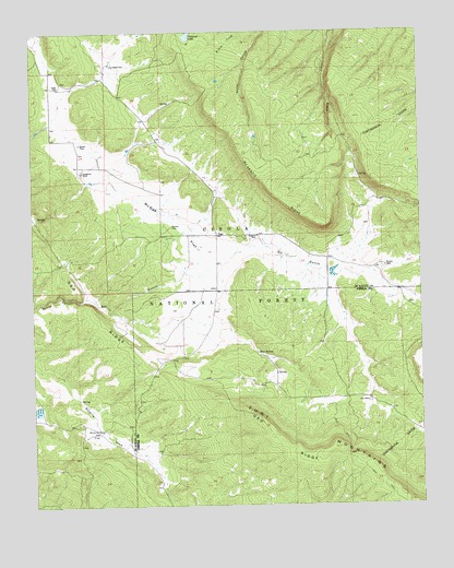
Page, NM USGS Topographic Map
Click on map above to begin viewing in our Map Viewer.

This topographic map contains these locations and features:
Feature Name Type Latitude Longitude GNIS ID View Map
Basgal PlaceLocaleN35.3664°W108.4734°903596View Map
Basgal TankReservoirN35.3670°W108.4633°914210View Map
Bear SpringSpringN35.2903°W108.4278°903670View Map
Bloomfield FlatFlatN35.2695°W108.4812°903931View Map
Blue TankReservoirN35.3570°W108.3967°914212View Map
Boon PlaceLocaleN35.2773°W108.3929°904006View Map
Bottom Stock TankReservoirN35.3321°W108.4084°937117View Map
Deer TankReservoirN35.3402°W108.3781°937116View Map
Grubisich PlaceLocaleN35.3209°W108.4276°906752View Map
Hausner Tank OneReservoirN35.3217°W108.4184°914218View Map
Hausner Tank ThreeReservoirN35.3198°W108.4209°1987489View Map
Hausner Tank TwoReservoirN35.3217°W108.4154°914219View Map
Lower Section Nineteen TankReservoirN35.3431°W108.4701°914215View Map
McKenzie RidgeRidgeN35.3325°W108.4234°908531View Map
McKenzie TankReservoirN35.3493°W108.4143°914217View Map
McQue FlatFlatN35.3267°W108.4584°908545View Map
Merrill PlaceLocaleN35.3456°W108.4848°908575View Map
Mesa TankReservoirN35.3472°W108.4284°914216View Map
Middle Section Nineteen TankReservoirN35.3441°W108.4695°1987488View Map
Natural LakeLakeN35.3741°W108.4497°909021View Map
Navarre PlaceLocaleN35.3236°W108.4554°909029View Map
PagePopulated PlaceN35.3211°W108.4406°909436View Map
Page Post Office (historical)Post OfficeN35.3211°W108.4406°937532View Map
Polich PlaceLocaleN35.3603°W108.4917°909775View Map
Radosevich RanchLocaleN35.3381°W108.4842°909954View Map
Rim Site TankReservoirN35.3609°W108.4391°914211View Map
Sanchez PlaceLocaleN35.3128°W108.3867°910720View Map
Sanchez TankReservoirN35.3214°W108.3923°914232View Map
Section Fourteen TankReservoirN35.2756°W108.4994°914233View Map
Silva RanchLocaleN35.3417°W108.4904°1987487View Map
Stump TankReservoirN35.3588°W108.3812°914213View Map
Upper Section Nineteen TankReservoirN35.3464°W108.4673°914214View Map

Note: Coordinates in the location and feature list above are referenced to NAD83 datum.


Copyright (C) 2008-2024 Ryan Niemi / Sunset Dynamics ... All Rights Reserved