TopoQuest Logo
Do you find TopoQuest useful?
Help keep TopoQuest running and adding new maps/features by donating!
Bitcoin:  19c7KJd3qBynnjoSw5npx9KScwjBe4ifkT
Litecoin:  LXs6TkuXGGXo1vDsWCkWVdjQX94eUKd6ui
Home View Maps Find Maps Find Places Resources & Links


Pattie Gap, Tennessee Topographic Map

USGS Map Title: Pattie Gap, TN
USGS Map MRC: 35084F5
DRG (GeoTIFF) Download: o35084f5.tif


Neighboring USGS Topographic Map Quads:


  Rockwood, TN  
35084G6
 

  Bacon Gap, TN  
35084G5
 

  Cave Creek, TN  
35084G4
 

  Ten Mile, TN  
35084F6
 

  Pattie Gap, TN  
35084F5
 

  Philadelphia, TN  
35084F4
 

  Tranquillity, TN  
35084E6
 

  Niota, TN  
35084E5
 

  Sweetwater, TN  
35084E4


Map MRC Location:

N36°
W85°
N36°
W84°
H8 H7 H6 H5 H4 H3 H2 H1
G8 G7 G6 G5 G4 G3 G2 G1
F8 F7 F6 F5 F4 F3 F2 F1
E8 E7 E6 E5 E4 E3 E2 E1
D8 D7 D6 D5 D4 D3 D2 D1
C8 C7 C6 C5 C4 C3 C2 C1
B8 B7 B6 B5 B4 B3 B2 B1
A8 A7 A6 A5 A4 A3 A2 A1
N35°
W85°
N35°
W84°

Pattie Gap, TN USGS 1:24K Topographic Map Preview:
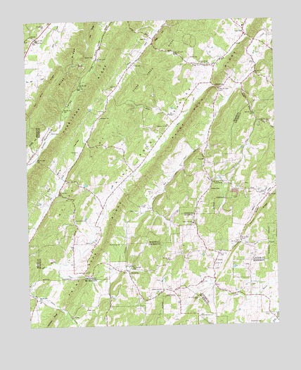
Pattie Gap, TN USGS Topographic Map
Click on map above to begin viewing in our Map Viewer.

This topographic map contains these locations and features:
Feature Name Type Latitude Longitude GNIS ID View Map
Basket CemeteryCemeteryN35.6590°W84.5963°1276427View Map
Big RidgeRidgeN35.7462°W84.5910°1277360View Map
Blue SpringSpringN35.6467°W84.5742°1277783View Map
Blue Spring CemeteryCemeteryN35.6581°W84.5785°1305307View Map
Blue Spring ChurchChurchN35.6492°W84.5760°1277800View Map
Blue Spring CreekStreamN35.6423°W84.6247°1305311View Map
Cedar ForkPopulated PlaceN35.6842°W84.5324°1314806View Map
Cedar ForkStreamN35.7004°W84.5358°1280022View Map
Cedar Fork ChurchChurchN35.6673°W84.5419°1305761View Map
Clark CemeteryCemeteryN35.6962°W84.5991°1280592View Map
Compromise ChurchChurchN35.6684°W84.6010°1306057View Map
Compromise School (historical)SchoolN35.6679°W84.6010°1316381View Map
Cook MillPopulated PlaceN35.6937°W84.5352°1281129View Map
Cooley SpringSpringN35.6832°W84.5267°1281153View Map
Deatherage CemeteryCemeteryN35.7478°W84.6149°1282270View Map
Dry Fork School (historical)SchoolN35.6923°W84.6008°1316385View Map
EriePopulated PlaceN35.6476°W84.5747°1283837View Map
Erie ChurchChurchN35.6470°W84.5969°1283838View Map
Fenders ChurchChurchN35.6498°W84.5313°1284201View Map
Fisher CemeteryCemeteryN35.6315°W84.5963°1284315View Map
Fuller CemeteryCemeteryN35.7320°W84.5705°1285017View Map
Gage CemeteryCemeteryN35.7423°W84.5638°1285063View Map
Gage HillSummitN35.7420°W84.5577°1285064View Map
Galyon CemeteryCemeteryN35.7348°W84.5424°1285110View Map
Galyon RidgeRidgeN35.6704°W84.5083°1285112View Map
Galyon SpringSpringN35.7325°W84.5371°1285113View Map
Hall CemeteryCemeteryN35.7228°W84.5824°1286564View Map
Hurricane RidgeRidgeN35.7254°W84.5888°1269667View Map
JohnsonPopulated PlaceN35.6723°W84.5624°1310435View Map
Johnson ChapelChurchN35.6740°W84.5685°1289584View Map
Little Paint Rock CreekStreamN35.7415°W84.5094°1291601View Map
LuttrellPopulated PlaceN35.6540°W84.5291°1315451View Map
Luttrell School (historical)SchoolN35.6517°W84.5302°1309558View Map
Matthews CemeteryCemeteryN35.7101°W84.5880°1292956View Map
Moore CemeteryCemeteryN35.7042°W84.6124°1294264View Map
Morrisgap (historical)Populated PlaceN35.7404°W84.5610°1310448View Map
Morrison Store (historical)LocaleN35.7309°W84.5305°1316421View Map
Mount Cumberland CemeteryCemeteryN35.6356°W84.5397°1294605View Map
Mount Cumberland ChurchChurchN35.6287°W84.5394°1294606View Map
Mud CreekStreamN35.6304°W84.5013°1275405View Map
Oak HillPopulated PlaceN35.7434°W84.6194°1315625View Map
Oak Hill School (historical)SchoolN35.7440°W84.6191°1316429View Map
Paint RockPopulated PlaceN35.7442°W84.5147°1296662View Map
Paint Rock RidgeRidgeN35.7034°W84.5480°1269845View Map
Paint Rock SchoolSchoolN35.7473°W84.5149°1316434View Map
Paint Rock ValleyValleyN35.6508°W84.6084°1296669View Map
Pattie GapGapN35.7226°W84.5294°1296972View Map
Pattie Gap (historical)Populated PlaceN35.7242°W84.5319°1310453View Map
Pleasant Hill ChurchChurchN35.7073°W84.5541°1297869View Map
Raby CemeteryCemeteryN35.6717°W84.5735°1298782View Map
Regret (historical)Populated PlaceN35.6320°W84.6069°1307560View Map
Richardson CemeteryCemeteryN35.6256°W84.5083°1299334View Map
Riley RidgeRidgeN35.7295°W84.6038°1299463View Map
Roberts CemeteryCemeteryN35.7353°W84.5905°1299625View Map
Salem ChurchChurchN35.7131°W84.5858°1300552View Map
Sandy BranchStreamN35.7231°W84.5172°1300733View Map
Sandy School (historical)SchoolN35.7015°W84.5127°1309625View Map
Shelton Grove ChurchChurchN35.6398°W84.5574°1303561View Map
South Roane County Volunteer Fire Department Station 2BuildingN35.7460°W84.5146°2654567View Map
South Roane County Volunteer Fire Department Station 4BuildingN35.6855°W84.6063°2654910View Map
Walker RidgeRidgeN35.6895°W84.5960°1273643View Map
West Fork Paint Rock CreekStreamN35.7187°W84.5219°1304468View Map
White BranchStreamN35.7087°W84.5469°1274332View Map

Note: Coordinates in the location and feature list above are referenced to NAD83 datum.


Copyright (C) 2008-2024 Ryan Niemi / Sunset Dynamics ... All Rights Reserved