TopoQuest Logo
Do you find TopoQuest useful?
Help keep TopoQuest running and adding new maps/features by donating!
Bitcoin:  19c7KJd3qBynnjoSw5npx9KScwjBe4ifkT
Litecoin:  LXs6TkuXGGXo1vDsWCkWVdjQX94eUKd6ui
Home View Maps Find Maps Find Places Resources & Links


Plattsburg, Missouri Topographic Map

USGS Map Title: Plattsburg, MO
USGS Map MRC: 39094E4
DRG (GeoTIFF) Download: o39094e4.tif


Neighboring USGS Topographic Map Quads:


  Hemple, MO  
39094F5
 

  Perrin, MO  
39094F4
 

  Cameron West, MO  
39094F3
 

  Gower, MO  
39094E5
 

  Plattsburg, MO  
39094E4
 

  Lathrop, MO  
39094E3
 

  Smithville, MO  
39094D5
 

  Arley, MO  
39094D4
 

  Holt, MO  
39094D3


Map MRC Location:

N40°
W95°
N40°
W94°
H8 H7 H6 H5 H4 H3 H2 H1
G8 G7 G6 G5 G4 G3 G2 G1
F8 F7 F6 F5 F4 F3 F2 F1
E8 E7 E6 E5 E4 E3 E2 E1
D8 D7 D6 D5 D4 D3 D2 D1
C8 C7 C6 C5 C4 C3 C2 C1
B8 B7 B6 B5 B4 B3 B2 B1
A8 A7 A6 A5 A4 A3 A2 A1
N39°
W95°
N39°
W94°

Plattsburg, MO USGS 1:24K Topographic Map Preview:
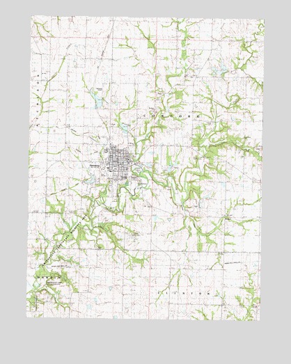
Plattsburg, MO USGS Topographic Map
Click on map above to begin viewing in our Map Viewer.

This topographic map contains these locations and features:
Feature Name Type Latitude Longitude GNIS ID View Map
Brethren ChurchChurchN39.5867°W94.4330°742130View Map
Calvary CemeteryCemeteryN39.5583°W94.4438°742126View Map
City of PlattsburgCivilN39.5644°W94.4615°2396228View Map
Clark Airport (historical)AirportN39.5292°W94.4502°758867View Map
Clinton CountyCivilN39.6018°W94.4046°758479View Map
Clinton County Sheriff's OfficeBuildingN39.5660°W94.4468°2752441View Map
Duncan SchoolSchoolN39.5075°W94.4044°717182View Map
Ellis Elementary SchoolSchoolN39.5621°W94.4540°2545205View Map
Everett Quarries Lake DamDamN39.5617°W94.4252°761781View Map
Forest Hill SchoolSchoolN39.6008°W94.3797°718088View Map
Funkhouser CreekStreamN39.5475°W94.4602°738203View Map
Greenlawn CemeteryCemeteryN39.5586°W94.4486°742125View Map
Grindstone CreekStreamN39.5718°W94.4090°718884View Map
Hanks CemeteryCemeteryN39.5289°W94.4627°742122View Map
Hartell LakeReservoirN39.6042°W94.4022°737856View Map
Hartell LakesReservoirN39.6026°W94.3986°760636View Map
Hartell Lakes DamDamN39.6033°W94.3986°760635View Map
Hartell Lakes DamDamN39.6050°W94.4019°760637View Map
Hazel Dell School (historical)SchoolN39.5744°W94.4138°719284View Map
Horse ForkStreamN39.5631°W94.4405°719850View Map
Jones SchoolSchoolN39.5478°W94.4905°720422View Map
Kimray AirportAirportN39.5667°W94.4147°758866View Map
Lake Concord DamDamN39.5567°W94.4652°761780View Map
Leg Church SchoolSchoolN39.6014°W94.4155°720900View Map
Log Church SchoolSchoolN39.6014°W94.4147°741443View Map
Lyon School (historical)SchoolN39.5419°W94.4052°721702View Map
McWilliams CemeteryCemeteryN39.5755°W94.3858°742128View Map
Mount Washington CemeteryCemeteryN39.5572°W94.4413°742124View Map
Newby LakeReservoirN39.5423°W94.4318°761235View Map
Newby Lake DamDamN39.5433°W94.4319°761234View Map
O'Connor Landing Strip (historical)AirportN39.5347°W94.4452°742123View Map
Perkins ParkParkN39.5614°W94.4416°742127View Map
PlattsburgPopulated PlaceN39.5656°W94.4480°730179View Map
Plattsburg AirparkAirportN39.5964°W94.4610°758864View Map
Plattsburg Fire Protection DistrictBuildingN39.5632°W94.4727°2621205View Map
Plattsburg High SchoolSchoolN39.5612°W94.4573°2545453View Map
Plattsburg Middle SchoolSchoolN39.5609°W94.4560°2545279View Map
Plattsburg Old ReservoirReservoirN39.5795°W94.4494°760634View Map
Plattsburg Old Reservoir DamDamN39.5783°W94.4486°760633View Map
Plattsburg Post OfficePost OfficeN39.5641°W94.4470°2782596View Map
Prairie Cottage School (historical)SchoolN39.5981°W94.4575°724831View Map
Reservoir BranchStreamN39.5722°W94.4430°738204View Map
Six Mile Lane LakeReservoirN39.5904°W94.4639°760632View Map
Six Mile Lane Lake DamDamN39.5900°W94.4619°760631View Map
Smithville Lake State Wildlife AreaParkN39.5333°W94.4772°742121View Map
Township of ConcordCivilN39.5867°W94.4232°766513View Map
Transue CemeteryCemeteryN39.5822°W94.4033°742129View Map
Walnut Grove School (historical)SchoolN39.5728°W94.3861°728316View Map
WexfordPopulated PlaceN39.5431°W94.3952°741353View Map

Note: Coordinates in the location and feature list above are referenced to NAD83 datum.


Copyright (C) 2008-2024 Ryan Niemi / Sunset Dynamics ... All Rights Reserved