TopoQuest Logo
Do you find TopoQuest useful?
Help keep TopoQuest running and adding new maps/features by donating!
Bitcoin:  19c7KJd3qBynnjoSw5npx9KScwjBe4ifkT
Litecoin:  LXs6TkuXGGXo1vDsWCkWVdjQX94eUKd6ui
Home View Maps Find Maps Find Places Resources & Links


Gower, Missouri Topographic Map

USGS Map Title: Gower, MO
USGS Map MRC: 39094E5
DRG (GeoTIFF) Download: o39094e5.tif


Neighboring USGS Topographic Map Quads:


  Agency, MO  
39094F6
 

  Hemple, MO  
39094F5
 

  Perrin, MO  
39094F4
 

  Edgerton, MO  
39094E6
 

  Gower, MO  
39094E5
 

  Plattsburg, MO  
39094E4
 

  Camden Point, MO  
39094D6
 

  Smithville, MO  
39094D5
 

  Arley, MO  
39094D4


Map MRC Location:

N40°
W95°
N40°
W94°
H8 H7 H6 H5 H4 H3 H2 H1
G8 G7 G6 G5 G4 G3 G2 G1
F8 F7 F6 F5 F4 F3 F2 F1
E8 E7 E6 E5 E4 E3 E2 E1
D8 D7 D6 D5 D4 D3 D2 D1
C8 C7 C6 C5 C4 C3 C2 C1
B8 B7 B6 B5 B4 B3 B2 B1
A8 A7 A6 A5 A4 A3 A2 A1
N39°
W95°
N39°
W94°

Gower, MO USGS 1:24K Topographic Map Preview:
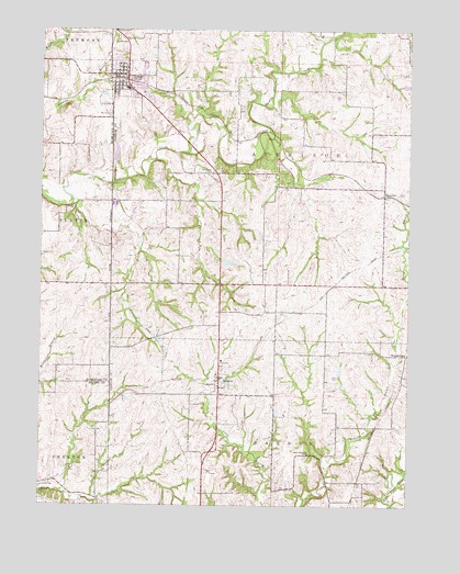
Gower, MO USGS Topographic Map
Click on map above to begin viewing in our Map Viewer.

This topographic map contains these locations and features:
Feature Name Type Latitude Longitude GNIS ID View Map
Allen CemeteryCemeteryN39.6028°W94.6022°713218View Map
Antioch CemeteryCemeteryN39.6228°W94.5997°713319View Map
Berry School (historical)SchoolN39.5219°W94.6019°746564View Map
Bill Woods Ranch LakeReservoirN39.5650°W94.5552°762532View Map
City of GowerCivilN39.6130°W94.5947°2394938View Map
East Buchanan Elementary SchoolSchoolN39.6096°W94.5968°2545389View Map
East Buchanan High SchoolSchoolN39.6095°W94.5959°2545456View Map
GowerPopulated PlaceN39.6108°W94.5994°718638View Map
Gower Fire Protection DistrictBuildingN39.6159°W94.5944°2620762View Map
Gower Police DepartmentBuildingN39.6130°W94.6004°2752140View Map
Gower Post OfficePost OfficeN39.6130°W94.5992°2782647View Map
Gower Reservoir DamDamN39.5901°W94.5995°761436View Map
GraysonPopulated PlaceN39.5333°W94.5644°730109View Map
Grayson CemeteryCemeteryN39.5267°W94.5736°718769View Map
Hord SchoolSchoolN39.5503°W94.5275°746567View Map
Hords Spur (historical)LocaleN39.5508°W94.5383°746568View Map
Morse LakeReservoirN39.5244°W94.5446°761336View Map
Morse Lake DamDamN39.5250°W94.5452°761335View Map
Mount Carmel CemeteryCemeteryN39.5878°W94.5669°722730View Map
Mount Carmel SchoolSchoolN39.5867°W94.5675°746563View Map
Mount Hope School (historical)SchoolN39.5969°W94.5136°746566View Map
ScearcesPopulated PlaceN39.5814°W94.5086°741243View Map
Stony Point ChurchChurchN39.5136°W94.5338°727153View Map
Stony Point School (historical)SchoolN39.5022°W94.5261°746569View Map
Township of AtchisonCivilN39.5930°W94.5456°766511View Map
Weakley LakeReservoirN39.5903°W94.5453°761424View Map
WestbridgePopulated PlaceN39.5394°W94.5008°741351View Map
Winn School (historical)SchoolN39.5036°W94.5691°746565View Map
Woods DamDamN39.5650°W94.5552°762531View Map
Zurbuchen Lake DamDamN39.5900°W94.5436°761423View Map

Note: Coordinates in the location and feature list above are referenced to NAD83 datum.


Copyright (C) 2008-2024 Ryan Niemi / Sunset Dynamics ... All Rights Reserved