TopoQuest Logo
Do you find TopoQuest useful?
Help keep TopoQuest running and adding new maps/features by donating!
Bitcoin:  19c7KJd3qBynnjoSw5npx9KScwjBe4ifkT
Litecoin:  LXs6TkuXGGXo1vDsWCkWVdjQX94eUKd6ui
Home View Maps Find Maps Find Places Resources & Links


Port Jefferson, Ohio Topographic Map

USGS Map Title: Port Jefferson, OH
USGS Map MRC: 40084C1
DRG (GeoTIFF) Download: o40084c1.tif


Neighboring USGS Topographic Map Quads:


  Botkins, OH  
40084D2
 

  Jackson Center, OH  
40084D1
 

  Russells Point, OH  
40083D8
 

  Sidney, OH  
40084C2
 

  Port Jefferson, OH  
40084C1
 

  De Graff, OH  
40083C8
 

  Piqua East, OH  
40084B2
 

  Fletcher, OH  
40084B1
 

  Saint Paris, OH  
40083B8


Map MRC Location:

N41°
W85°
N41°
W84°
H8 H7 H6 H5 H4 H3 H2 H1
G8 G7 G6 G5 G4 G3 G2 G1
F8 F7 F6 F5 F4 F3 F2 F1
E8 E7 E6 E5 E4 E3 E2 E1
D8 D7 D6 D5 D4 D3 D2 D1
C8 C7 C6 C5 C4 C3 C2 C1
B8 B7 B6 B5 B4 B3 B2 B1
A8 A7 A6 A5 A4 A3 A2 A1
N40°
W85°
N40°
W84°

Port Jefferson, OH USGS 1:24K Topographic Map Preview:
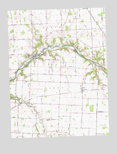
Port Jefferson, OH USGS Topographic Map
Click on map above to begin viewing in our Map Viewer.

This topographic map contains these locations and features:
Feature Name Type Latitude Longitude GNIS ID View Map
Allen School (historical)SchoolN40.3314°W84.1183°1053841View Map
Carmony School (historical)SchoolN40.2723°W84.0336°1053855View Map
Cedar Point CemeteryCemeteryN40.2825°W84.0994°1038910View Map
Counts RunStreamN40.3345°W84.0819°1039399View Map
Fairlawn Elementary SchoolSchoolN40.2970°W84.0319°1081290View Map
Fairlawn High SchoolSchoolN40.2670°W84.0761°1040314View Map
Glen CemeteryCemeteryN40.3237°W84.1035°1040894View Map
Indian CreekStreamN40.3189°W84.0152°1041938View Map
Leatherwood CreekStreamN40.2656°W84.0883°1042456View Map
Line RunStreamN40.3095°W84.1049°1066071View Map
Little Indian CreekStreamN40.3139°W84.0163°1042629View Map
Little Turkeyfoot CreekStreamN40.3284°W84.0672°1065887View Map
Lockard School (historical)SchoolN40.3609°W84.1188°1053886View Map
Manning RunStreamN40.3167°W84.1116°1042923View Map
Medaris CemeteryCemeteryN40.3053°W84.1052°1043203View Map
Mill Valley FarmsLocaleN40.2831°W84.1069°2628469View Map
Mosquito CreekStreamN40.2653°W84.0883°1066102View Map
Old Dunkard CemeteryCemeteryN40.2742°W84.0916°1044102View Map
PascoPopulated PlaceN40.2834°W84.1008°1049065View Map
Pasco Post Office (historical)Post OfficeN40.2834°W84.1013°2055272View Map
Pasco United Methodist ChurchChurchN40.2837°W84.1011°1066432View Map
PembertonPopulated PlaceN40.2948°W84.0324°1049069View Map
Pemberton Post OfficePost OfficeN40.2945°W84.0319°2055299View Map
Perry - Port - Salem Rescue SquadBuildingN40.3298°W84.0931°2550906View Map
Pioneer CemeteryCemeteryN40.3331°W84.0900°1044487View Map
Port JeffersonPopulated PlaceN40.3287°W84.0944°1061565View Map
Port Jefferson Community Fire CompanyBuildingN40.3305°W84.0926°2549293View Map
Port Jefferson Police DepartmentBuildingN40.3299°W84.0928°2733003View Map
Port Jefferson Post OfficePost OfficeN40.3292°W84.0944°2055300View Map
Port Jefferson SchoolSchoolN40.3298°W84.0933°1071659View Map
Port Jefferson United Methodist ChurchChurchN40.3284°W84.0952°1066433View Map
Reeder DitchCanalN40.2548°W84.0508°1044912View Map
Roberts CemeteryCemeteryN40.3490°W84.0849°1045085View Map
School Number 3 (historical)SchoolN40.3606°W84.0947°1053909View Map
School Number 3 (historical)SchoolN40.3187°W84.0738°1053910View Map
School Number 4 (historical)SchoolN40.3492°W84.0749°1053911View Map
School Number 5 (historical)SchoolN40.2773°W84.0980°1053922View Map
School Number 6 (historical)SchoolN40.3056°W84.0983°1053924View Map
School Number 7 (historical)SchoolN40.3178°W84.0399°1053927View Map
Staley CemeteryCemeteryN40.3157°W84.1186°1046621View Map
Township of PerryCivilN40.2946°W84.0668°1086967View Map
Township of SalemCivilN40.3540°W84.0681°1086968View Map
Turkeyfoot CreekStreamN40.3370°W84.0705°1066246View Map
Village of Port JeffersonCivilN40.3304°W84.0925°2399004View Map
Walnut Grove School (historical)SchoolN40.3537°W84.0466°1053948View Map
Ward CemeteryCemeteryN40.3227°W84.0543°1047558View Map

Note: Coordinates in the location and feature list above are referenced to NAD83 datum.


Copyright (C) 2008-2024 Ryan Niemi / Sunset Dynamics ... All Rights Reserved