TopoQuest Logo
Do you find TopoQuest useful?
Help keep TopoQuest running and adding new maps/features by donating!
Bitcoin:  19c7KJd3qBynnjoSw5npx9KScwjBe4ifkT
Litecoin:  LXs6TkuXGGXo1vDsWCkWVdjQX94eUKd6ui
Home View Maps Find Maps Find Places Resources & Links


Readyville, Tennessee Topographic Map

USGS Map Title: Readyville, TN
USGS Map MRC: 35086G2
DRG (GeoTIFF) Download: o35086g2.tif


Neighboring USGS Topographic Map Quads:


  Lascassas, TN  
35086H3
 

  Milton, TN  
35086H2
 

  Auburntown, TN  
35086H1
 

  Dillton, TN  
35086G3
 

  Readyville, TN  
35086G2
 

  Woodbury, TN  
35086G1
 

  Webbs Jungle, TN  
35086F3
 

  Beechgrove, TN  
35086F2
 

  Hollow Springs, TN  
35086F1


Map MRC Location:

N36°
W87°
N36°
W86°
H8 H7 H6 H5 H4 H3 H2 H1
G8 G7 G6 G5 G4 G3 G2 G1
F8 F7 F6 F5 F4 F3 F2 F1
E8 E7 E6 E5 E4 E3 E2 E1
D8 D7 D6 D5 D4 D3 D2 D1
C8 C7 C6 C5 C4 C3 C2 C1
B8 B7 B6 B5 B4 B3 B2 B1
A8 A7 A6 A5 A4 A3 A2 A1
N35°
W87°
N35°
W86°

Readyville, TN USGS 1:24K Topographic Map Preview:
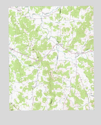
Readyville, TN USGS Topographic Map
Click on map above to begin viewing in our Map Viewer.

This topographic map contains these locations and features:
Feature Name Type Latitude Longitude GNIS ID View Map
Adams Poultry FarmLocaleN35.8694°W86.1297°2635245View Map
Alexanders Mill (historical)LocaleN35.8603°W86.2014°1645512View Map
Andrews CreekStreamN35.8548°W86.2014°1304840View Map
Antioch ChurchChurchN35.8631°W86.1936°1304854View Map
Arentt School (historical)SchoolN35.8356°W86.2055°1323452View Map
Arnett CemeteryCemeteryN35.8364°W86.1958°1645517View Map
Ashley CemeteryCemeteryN35.7695°W86.2358°1645518View Map
Barton CemeteryCemeteryN35.8112°W86.1500°1643499View Map
Benson CemeteryCemeteryN35.8473°W86.1850°1645531View Map
Bevins CemeteryCemeteryN35.8453°W86.1964°1645532View Map
Bragg CemeteryCemeteryN35.8373°W86.1394°1643511View Map
Bragg CemeteryCemeteryN35.8364°W86.1386°1643512View Map
Bragg CemeteryCemeteryN35.8192°W86.1347°1643513View Map
Brandon CemeteryCemeteryN35.7892°W86.1453°1643515View Map
Brandon CemeteryCemeteryN35.8220°W86.2219°1645550View Map
Brawleys ForkStreamN35.8040°W86.1525°1269376View Map
Bryson HollowValleyN35.8509°W86.1274°1647247View Map
BurtPopulated PlaceN35.7692°W86.1294°1314776View Map
Burt Baptist ChurchChurchN35.7720°W86.1292°1643519View Map
Burt School (historical)SchoolN35.7681°W86.1275°1322645View Map
Carnahan CemeteryCemeteryN35.8142°W86.2378°1645568View Map
Carson ForkStreamN35.8101°W86.1572°1279762View Map
Carter CemeteryCemeteryN35.8314°W86.1389°1643520View Map
CatestonPopulated PlaceN35.7948°W86.1505°1643521View Map
Cateston CemeteryCemeteryN35.7967°W86.1511°1305729View Map
Commissioner District 1CivilN35.7800°W86.1394°2464213View Map
Cripple Creek CemeteryCemeteryN35.7784°W86.2133°1645597View Map
Cripple Creek ChurchChurchN35.7781°W86.2133°1306180View Map
CulpepperPopulated PlaceN35.8184°W86.1428°1306223View Map
CurleePopulated PlaceN35.7776°W86.1594°1281885View Map
Curlee CemeteryCemeteryN35.7801°W86.1630°1643529View Map
Curlee Church of ChristChurchN35.7776°W86.1636°1643530View Map
Curlee School (historical)SchoolN35.7776°W86.1622°1322647View Map
Daniel CemeteryCemeteryN35.8401°W86.1889°1645600View Map
Davis-Thomas CemeteryCemeteryN35.7692°W86.1325°1643535View Map
Dunn CemeteryCemeteryN35.8053°W86.1886°1645615View Map
Dunn CemeteryCemeteryN35.8087°W86.1836°1645616View Map
Dunn CemeteryCemeteryN35.8023°W86.2117°1645617View Map
Floraton Church (historical)ChurchN35.7953°W86.2486°1323489View Map
Gandy CemeteryCemeteryN35.8059°W86.1383°1643582View Map
Gooch FordCrossingN35.8376°W86.1892°1647687View Map
Gowen KnobSummitN35.7503°W86.2478°1285765View Map
Hall CemeteryCemeteryN35.8164°W86.2233°1645670View Map
Halls HillPopulated PlaceN35.8698°W86.2350°1286610View Map
Harris CemeteryCemeteryN35.8448°W86.1255°1643558View Map
Haws Spring ForkStreamN35.7667°W86.1314°1287205View Map
Herrod CemeteryCemeteryN35.7909°W86.2325°1645690View Map
Herrod CemeteryCemeteryN35.8098°W86.2255°1645691View Map
Hickory Grove ChurchChurchN35.8098°W86.2103°1287590View Map
Hollis CreekStreamN35.8187°W86.1280°1288074View Map
Hoover CemeteryCemeteryN35.8542°W86.2367°1288272View Map
Hoover CemeteryCemeteryN35.8026°W86.1819°1645699View Map
Huddleston CemeteryCemeteryN35.8223°W86.1853°1645704View Map
Jamison CemeteryCemeteryN35.8334°W86.2053°1645717View Map
Johnson CemeteryCemeteryN35.7676°W86.2367°1645730View Map
Jones CemeteryCemeteryN35.8231°W86.1875°1645732View Map
Jones-McElroy CemeteryCemeteryN35.7865°W86.2394°1645735View Map
KittrellPopulated PlaceN35.8237°W86.2447°1290327View Map
Kittrell Census Designated PlaceCensusN35.8245°W86.2393°2584582View Map
Kittrell Elementary SchoolSchoolN35.8240°W86.2447°1323511View Map
Kittrell Volunteer Fire DepartmentBuildingN35.8237°W86.2450°2653732View Map
Lassiter CemeteryCemeteryN35.7812°W86.1755°1643578View Map
Locke CreekStreamN35.8170°W86.1436°1291764View Map
Lyon CemeteryCemeteryN35.7617°W86.2225°1645765View Map
Marion Baptist Church (historical)ChurchN35.7970°W86.1508°1643583View Map
McCrary CemeteryCemeteryN35.7598°W86.2133°1645793View Map
McElroy BranchStreamN35.8212°W86.2497°1293270View Map
McKnight BranchStreamN35.8634°W86.2028°1293390View Map
McKnight-Wright CemeteryCemeteryN35.8717°W86.2333°1645798View Map
New HopePopulated PlaceN35.8201°W86.1603°1652596View Map
New Hope ChurchChurchN35.8201°W86.1597°1295538View Map
Parrot CemeteryCemeteryN35.7912°W86.1958°1645856View Map
Peak CemeteryCemeteryN35.8145°W86.1980°1645865View Map
Peaks HillSummitN35.8137°W86.2058°1297064View Map
Pilot KnobSummitN35.8226°W86.2128°1297482View Map
Ready CemeteryCemeteryN35.8539°W86.1294°1643626View Map
Ready CemeteryCemeteryN35.8270°W86.1808°1645890View Map
ReadyvillePopulated PlaceN35.8281°W86.1747°1299014View Map
Readyville High School (historical)SchoolN35.8290°W86.1730°1643627View Map
Readyville MillLocaleN35.8303°W86.1764°1643628View Map
Readyville Post OfficePost OfficeN35.8293°W86.1792°1650174View Map
Reed CreekStreamN35.7809°W86.2089°1299140View Map
Reed HollowValleyN35.7736°W86.1631°1647256View Map
Richardson CemeteryCemeteryN35.8281°W86.2478°1645893View Map
Ring CemeteryCemeteryN35.7726°W86.2197°1645897View Map
Rock Hill ChurchChurchN35.7587°W86.2478°1299764View Map
Saffel CemeteryCemeteryN35.8067°W86.1605°1643636View Map
Sagely CemeteryCemeteryN35.7523°W86.2094°1645913View Map
Sanford CemeteryCemeteryN35.8645°W86.2233°1645921View Map
Science Hill ChurchChurchN35.8226°W86.2447°1300908View Map
Simpson CemeteryCemeteryN35.7792°W86.1350°1643639View Map
Smith CemeteryCemeteryN35.8573°W86.1403°1643641View Map
Smith CemeteryCemeteryN35.8545°W86.2000°1645935View Map
South Side SchoolSchoolN35.8190°W86.1503°1303734View Map
Stones River ChurchChurchN35.8626°W86.1961°1303858View Map
Talley HillSummitN35.8303°W86.1753°1643648View Map
The CornersLocaleN35.8295°W86.1792°1645962View Map
Thomas HollowValleyN35.7560°W86.1389°1647259View Map
Thompson CemeteryCemeteryN35.8206°W86.1278°1643651View Map
Thompson CemeteryCemeteryN35.8670°W86.2294°1645964View Map
Todd CemeteryCemeteryN35.7523°W86.1292°1643655View Map
Travis CemeteryCemeteryN35.8559°W86.1594°1643659View Map
Tucker CemeteryCemeteryN35.8487°W86.1328°1643660View Map
Wards Grove CemeteryCemeteryN35.8631°W86.2236°1645994View Map
Wards Grove ChurchChurchN35.8626°W86.2236°1304377View Map
West Side Volunteer Fire DepartmentBuildingN35.8189°W86.1510°2654799View Map
Widow Wrights Mill (historical)LocaleN35.8526°W86.2028°1323590View Map
Wilson Hill ChurchChurchN35.8273°W86.2217°1274830View Map
Wood CemeteryCemeteryN35.8117°W86.1739°1643664View Map
Youree CemeteryCemeteryN35.8184°W86.2339°1646028View Map
Youree CemeteryCemeteryN35.7803°W86.2461°1646029View Map

Note: Coordinates in the location and feature list above are referenced to NAD83 datum.


Copyright (C) 2008-2024 Ryan Niemi / Sunset Dynamics ... All Rights Reserved