TopoQuest Logo
Do you find TopoQuest useful?
Help keep TopoQuest running and adding new maps/features by donating!
Bitcoin:  19c7KJd3qBynnjoSw5npx9KScwjBe4ifkT
Litecoin:  LXs6TkuXGGXo1vDsWCkWVdjQX94eUKd6ui
Home View Maps Find Maps Find Places Resources & Links


Lascassas, Tennessee Topographic Map

USGS Map Title: Lascassas, TN
USGS Map MRC: 35086H3
DRG (GeoTIFF) Download: o35086h3.tif


Neighboring USGS Topographic Map Quads:


  Gladeville, TN  
36086A4
 

  Vine, TN  
36086A3
 

  Watertown, TN  
36086A2
 

  Walterhill, TN  
35086H4
 

  Lascassas, TN  
35086H3
 

  Milton, TN  
35086H2
 

  Murfreesboro, TN  
35086G4
 

  Dillton, TN  
35086G3
 

  Readyville, TN  
35086G2


Map MRC Location:

N36°
W87°
N36°
W86°
H8 H7 H6 H5 H4 H3 H2 H1
G8 G7 G6 G5 G4 G3 G2 G1
F8 F7 F6 F5 F4 F3 F2 F1
E8 E7 E6 E5 E4 E3 E2 E1
D8 D7 D6 D5 D4 D3 D2 D1
C8 C7 C6 C5 C4 C3 C2 C1
B8 B7 B6 B5 B4 B3 B2 B1
A8 A7 A6 A5 A4 A3 A2 A1
N35°
W87°
N35°
W86°

Lascassas, TN USGS 1:24K Topographic Map Preview:
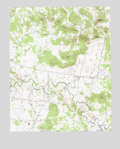
Lascassas, TN USGS Topographic Map
Click on map above to begin viewing in our Map Viewer.

This topographic map contains these locations and features:
Feature Name Type Latitude Longitude GNIS ID View Map
Alsup CemeteryCemeteryN35.9731°W86.3194°1645515View Map
Baker FieldAirportN35.9211°W86.3450°2675519View Map
Barlow CemeteryCemeteryN35.9539°W86.2797°1645520View Map
Bear BranchStreamN35.9153°W86.3669°1276570View Map
BethelPopulated PlaceN35.9656°W86.3650°1647685View Map
Bethel SchoolSchoolN35.9642°W86.3664°1277139View Map
Bethlehem ChurchChurchN35.8906°W86.3403°1305170View Map
Bowling CemeteryCemeteryN35.8862°W86.2955°1278060View Map
Boyd CemeteryCemeteryN35.8867°W86.3355°1278105View Map
Bradley CreekStreamN35.9201°W86.3055°1278188View Map
Brian ManorPopulated PlaceN35.9101°W86.3228°1313026View Map
BriarwoodPopulated PlaceN35.9084°W86.3083°1313027View Map
Brown CemeteryCemeteryN35.9078°W86.2914°1645556View Map
Brown CemeteryCemeteryN35.9178°W86.2811°1645557View Map
Brown CemeteryCemeteryN35.8848°W86.2930°1278543View Map
Browns MillPopulated PlaceN35.9023°W86.2808°1314746View Map
Browns Mill DamDamN35.9017°W86.2817°1302199View Map
Browns Mill LakeReservoirN35.9017°W86.2817°1302198View Map
Bushman CreekStreamN35.9184°W86.3450°1305562View Map
Buzzard RoostSummitN35.9090°W86.2630°1279227View Map
CanebrakePopulated PlaceN35.9348°W86.2989°1313033View Map
Carter CemeteryCemeteryN35.9828°W86.3447°1305708View Map
Casons KnobsSummitN35.9684°W86.2803°1279854View Map
Church KnobSummitN35.9440°W86.3214°1313036View Map
Commissioner District 2CivilN35.9356°W86.2762°2463968View Map
ComptonPopulated PlaceN35.9048°W86.3289°1281049View Map
Compton CemeteryCemeteryN35.9037°W86.3161°1281051View Map
Compton MeadowsPopulated PlaceN35.9076°W86.3478°1313037View Map
Crawford CemeteryCemeteryN35.9262°W86.3672°1645594View Map
Cripple CreekStreamN35.8803°W86.2644°1306179View Map
Delay EstatesPopulated PlaceN35.9281°W86.2764°1313048View Map
Dement CemeteryCemeteryN35.9326°W86.2680°1645605View Map
Dickson CemeteryCemeteryN35.9409°W86.2853°1645606View Map
Dill CemeteryCemeteryN35.8903°W86.2819°1645607View Map
Dillon CemeteryCemeteryN35.9392°W86.3205°1645608View Map
Donnell CemeteryCemeteryN35.9401°W86.2661°1282636View Map
Drenan CemeteryCemeteryN35.9939°W86.3592°1282789View Map
Dry BranchStreamN35.9206°W86.3700°1282850View Map
Dunaway CemeteryCemeteryN35.9595°W86.3336°1645618View Map
Dunaway ChapelChurchN35.9720°W86.3286°1283134View Map
Dunaway Chapel CemeteryCemeteryN35.9717°W86.3289°1645619View Map
Emery CemeteryCemeteryN35.9059°W86.3336°1283748View Map
Emery EstatesPopulated PlaceN35.8912°W86.3444°1313052View Map
Emery SchoolSchoolN35.8945°W86.3450°1283749View Map
Emery United Methodist ChurchChurchN35.8951°W86.3450°1323481View Map
Esquire EstatesPopulated PlaceN35.9073°W86.3694°1313055View Map
Estes AcresPopulated PlaceN35.9631°W86.3717°1313054View Map
Fairfield EstatesPopulated PlaceN35.8992°W86.3614°1313056View Map
Farmington EstatesPopulated PlaceN35.9009°W86.3433°1313058View Map
FieldcrestPopulated PlaceN35.9084°W86.3380°1313059View Map
Grandfather KnobSummitN35.9865°W86.2650°1285822View Map
Hall CemeteryCemeteryN35.9473°W86.3455°1645673View Map
Halls KnobSummitN35.9845°W86.3158°1286611View Map
Holly Grove ChurchChurchN35.9751°W86.3389°1288106View Map
Jarman BranchStreamN35.9287°W86.2844°1289303View Map
Jarmen CemeteryCemeteryN35.9631°W86.2644°1645718View Map
Jarmen CemeteryCemeteryN35.9562°W86.2608°1645719View Map
Jerrerson FarmsPopulated PlaceN35.9390°W86.3372°1313090View Map
Johns CemeteryCemeteryN35.9578°W86.3214°1645723View Map
Johns CemeteryCemeteryN35.9745°W86.3439°1645724View Map
Johns CemeteryCemeteryN35.9653°W86.3380°1645725View Map
Jordan CemeteryCemeteryN35.9826°W86.3025°1289836View Map
Jordan CemeteryCemeteryN35.8851°W86.3567°1645738View Map
Jordan School (historical)SchoolN35.8898°W86.3408°1323509View Map
Kerr CemeteryCemeteryN35.8889°W86.2717°1290101View Map
Lasater CemeteryCemeteryN35.9676°W86.2911°1645746View Map
LascassasPopulated PlaceN35.9303°W86.2911°1290656View Map
Lascassas Baptist ChurchChurchN35.9298°W86.2889°1645748View Map
Lascassas Census Designated PlaceCensusN35.9410°W86.2894°2584584View Map
Lascassas Colonial AcresPopulated PlaceN35.9345°W86.2655°1313105View Map
Lascassas Division (historical)CensusN35.9584°W86.3280°1648936View Map
Lascassas High SchoolSchoolN35.9295°W86.2758°1323519View Map
Lascassas Post OfficePost OfficeN35.9301°W86.2901°1652149View Map
Lascassas Volunteer Fire Department HeadquartersBuildingN35.9298°W86.2751°2654172View Map
Little Bethel ChurchChurchN35.9598°W86.3661°1291387View Map
LoftonPopulated PlaceN35.9287°W86.2725°1291812View Map
Martin CemeteryCemeteryN35.9412°W86.2958°1645783View Map
Martin CemeteryCemeteryN35.9342°W86.2950°1645784View Map
Mason KnobSummitN35.9881°W86.3230°1292891View Map
Mathews LakeReservoirN35.9313°W86.3560°1292927View Map
Mathews Lake DamDamN35.9306°W86.3558°1307172View Map
McDaniel CemeteryCemeteryN35.9420°W86.3292°1645794View Map
Murfreesboro QuarryMineN35.8758°W86.3250°2633135View Map
Murfreesboro Water Treatment PlantLocaleN35.9196°W86.3742°2454003View Map
New Las Casas (historical)Populated PlaceN35.9528°W86.2805°1645839View Map
Nolan School (historical)SchoolN35.8953°W86.3083°1647823View Map
Northcutt CemeteryCemeteryN35.8762°W86.2667°1295955View Map
Oak HillPopulated PlaceN35.8762°W86.3583°1313129View Map
Oakland EstatesPopulated PlaceN35.8840°W86.3561°1313131View Map
Oakland High SchoolSchoolN35.8828°W86.3517°1323544View Map
Owen CemeteryCemeteryN35.9387°W86.3483°1645853View Map
Owen CemeteryCemeteryN35.9339°W86.3344°1296563View Map
Patterson CemeteryCemeteryN35.9642°W86.3280°1296942View Map
Pearcy CemeteryCemeteryN35.9676°W86.3025°1645866View Map
Pitts CemeteryCemeteryN35.8848°W86.3367°1297761View Map
Pitts CemeteryCemeteryN35.8803°W86.3414°1645870View Map
Reeves CemeteryCemeteryN35.9023°W86.2900°1645892View Map
Republican Grove ChurchChurchN35.9012°W86.3339°1299225View Map
RiverwoodPopulated PlaceN35.9334°W86.3211°1313159View Map
Rucker CemeteryCemeteryN35.9201°W86.3305°1645908View Map
Rucker KnobSummitN35.9501°W86.3047°1300228View Map
Rucker-Pitts CemeteryCemeteryN35.9078°W86.3578°1645909View Map
Rutherford County LandfillLocaleN35.9311°W86.3661°2677875View Map
Saint JohnsPopulated PlaceN35.9742°W86.2547°1312882View Map
Saint Johns ChurchChurchN35.9745°W86.2550°1300449View Map
Saint Johns School (historical)SchoolN35.9748°W86.2544°1323243View Map
Sharp CemeteryCemeteryN35.9126°W86.3419°1645928View Map
Sharpsville ChurchChurchN35.8792°W86.2747°1301282View Map
Silver Hill School (historical)SchoolN35.9928°W86.3728°1323565View Map
Thompson CemeteryCemeteryN35.9037°W86.3219°1272520View Map
Tune CemeteryCemeteryN35.9773°W86.3447°1272979View Map
Two HillsPopulated PlaceN35.8987°W86.3292°1313182View Map
ValleyviewPopulated PlaceN35.9726°W86.3233°1314448View Map
Van Moors Mill (historical)LocaleN35.8792°W86.3467°1323585View Map
Vaugh CemeteryCemeteryN35.8856°W86.3492°1304299View Map
Vaughters KnobSummitN35.9876°W86.3325°1273417View Map
Wade CemeteryCemeteryN35.9489°W86.3700°1645981View Map
Wades BranchStreamN35.9428°W86.3744°1273523View Map
Walnut Grove ChurchChurchN35.8781°W86.3389°1273724View Map
Walter Hill ChurchChurchN35.9473°W86.3744°1304363View Map
Walter Hill DamDamN35.9417°W86.3733°1302217View Map
Walter Hill LakeReservoirN35.9417°W86.3733°1302216View Map
Walter Hill Volunteer Fire Department Station 1 HeadquartersBuildingN35.9414°W86.3611°2653656View Map
Walterhill Census Designated PlaceCensusN35.9572°W86.3679°2402982View Map
Ward CemeteryCemeteryN35.9962°W86.3708°1273780View Map
Williford CemeteryCemeteryN35.8814°W86.2542°1646014View Map
Yandell CemeteryCemeteryN35.9201°W86.3605°1646026View Map

Note: Coordinates in the location and feature list above are referenced to NAD83 datum.


Copyright (C) 2008-2024 Ryan Niemi / Sunset Dynamics ... All Rights Reserved